It may be years before FEMA maps show the full flood risk to Vermont communities
Residents listen during the second public forum to plan recovery and rebuilding in the aftermath of the July 2023 floods, held at the Statehouse in Montpelier on Tuesday, Aug. 22. Photo by Glenn Russell/VTDigger
On Tuesday, dozens of Montpelier residents gathered to discuss ideas for improving the city’s relationship with the three rivers that run inside its borders.
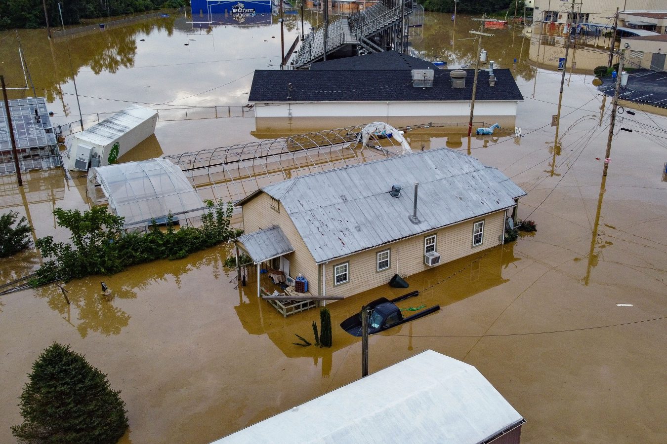
The stakes were high. Just over a month earlier, Montpelier had been inundated with 4 to 6 feet of floodwaters, destroying or damaging large portions of the downtown area and residential neighborhoods.
Amid discussion of building up water infrastructure and restoring upstream floodplains, one key question circled: How far and how high did the flood go, exactly?
One resident, who did not give his full name, made a request for “accessible and easy-to-understand maps” that could tell Montpelierites “where did the rain come from that comes into the city?”
Those maps, to an extent, already exist. The Federal Emergency Management Agency maintains the largest database of estimated flood hazards in the nation, including for Montpelier and many other Vermont communities.
The data that powers these maps — the data that determines federal regulations on flood insurance and community participation in flood programs — is collected through a painfully in-depth and yearslong process of studying the hydrology and geology of every section of river in Vermont.
Which is why, according to FEMA, many of these maps are years or even decades out of date.
One of the latest flood studies in Vermont, for Washington County, was completed in 2013, according to FEMA’s flood study website. But because the study took years to complete, it doesn’t even include data on what happened during Tropical Storm Irene 12 years ago, or during a May 2011 rainstorm that flooded Montpelier with several inches of water.
In other locations in Vermont, far older studies power their flood maps. Windham County, with communities hit hard in Tropical Storm Irene, hasn’t had an update since 2007. Some flood studies date all the way back to 1977, during the decade when the maps were first created by regulatory mandate.
FEMA redoes its flood studies on a rolling basis for different communities, said Kerry Bogdan, a spokesperson for the agency. She cited budget constraints as one reason for the delays.
“Congress does not give the agency enough money to, every time they do a study, to update the engineering on every single flooding source within that geography,” she said.
At least 13 Vermont watersheds are in the process of having flood studies right now, said Chris Hutchins, a senior program specialist who works on flood maps for FEMA. The furthest along is the Deerfield River watershed study in Bennington County, where FEMA recently released preliminary maps for communities to review.
But the 2023 floods are not yet included in those studies, and it’s unclear at this point if and how they will be. Bogdan said FEMA has commissioned a separate study to review the data from the 2023 floods, and evaluate if they would invalidate or complicate the other ongoing flood studies.
Either way, new maps are still years away from the finish line. Hutchins said the earliest Vermont can expect finalized maps would be 2025 or 2026, “barring no hiccups.”
Bogdan pointed out that data from historic floods is only one component of flood studies. Changes in the topology of the area, or in water-related infrastructure like culverts and dams, also determine when and how flood studies are conducted.
FEMA develops a “prioritization” schedule based on engineering and conversations with local officials about what’s been observed on the ground, she said.
Researchers across the country are looking at ways to make the process for determining flood risk go faster. In a 2021 paper on alternative flood models, University of Vermont researcher Rebecca Diehl called the traditional process “insufficient” and “data- and resource-intensive.”
In an email to VTDigger, she said there are numerous challenges with the current system — including the amount of data collection needed to detail the risk faced by specific properties.
“We make decisions (and) tradeoffs between getting these details right, and capturing the general inundation patterns that are likely to occur,” she said via email.
What does a flood map mean?
Under the National Flood Insurance Act of 1968, FEMA was given a specific goal when creating flood maps: To determine whether specific property owners were required to purchase flood insurance because they were in a high-risk flood zone.
These Special Flood Hazard Areas, sometimes referred to as 100-year flood zones, also determine how communities in the National Flood Insurance Program regulate development in floodplains.
But the “100-year flood” term is a bit of a misnomer. Bogdan said the agency has moved away from using that term in favor of calling those areas “1% annual chance events.” In other words, that flood has a 1% annual chance of occurring.
“People think it’s only going to happen in every 100 years, right like it happened in 1927. So we shouldn’t be dealing with it again until 2027, right?” she said. But in actuality, “unfortunately, you could have 100-year, or a 1% chance, flood three times in a month, three times in a year. (Or) you could have 100 years go by and never experience that.”
Another way FEMA describes it: If a homeowner has a 30-year mortgage, there’s a one-in-three chance that a flood will reach the ground floor before the mortgage is paid off.
Those chances are further complicated by the fact that up to 40% of flood insurance claims come from outside of flood zones, according to FEMA. Vermonters in the recent floods have reported that they were affected, even though their homes were outside the FEMA flood zones.
Conversely, some Vermont communities have a greater than 1% annual chance of flooding, although it’s not marked on the FEMA flood maps. A review of flood studies for Washington County, for example, reveals that some roads and bridges have a 2% chance or even a 10% chance of flooding each year.
In recent years, the biggest challenge to how FEMA flood maps are created has come from climate research groups, which claim the agency underestimates flood risk by not taking into account how climate change could increase the chances of extreme weather.
First Street Foundation, a nonprofit that publishes and sells risk factor data, estimates that 15% of Vermont properties are located in a 1% annual chance flood zone, compared to FEMA’s 1.6% to 8% of properties, depending on the county.
“In the absence of a property-specific risk model, (FEMA maps) have been used as a default tool for understanding property-specific flood risk. And because of that, you know, they’re really being used for something they’re not designed for,” said Jeremy Porter, head of climate implications at First Street Foundation.
The nonprofit organization incorporates real-world data on river heights, elevation and property zones, but makes different assumptions than FEMA does about the likelihood of extreme weather events, Porter said. It provides free data on its website and sells more in-depth, premium data at an additional cost.
Diehl, the UVM researcher, said via email that climate change means “catastrophic storms” will become more common, shifting the meaning of the 1% flood zone and expanding areas that are regularly flooded.
While flood maps are based on river flooding, she said, the traditional models do not account for flooding that comes directly from hard, fast rain, which is more likely during intense storms. One example would be the flash flooding that occurred in Addison County during heavy rainstorms in early August.
Porter said that, by calculating the chance of extreme weather in a particular area based on historical events, “you’re inherently taking the average of a period that’s already passed.”
“If you don’t incorporate climate metrics that allow you to understand the trending in that data over time, and integrate that into the future, then you end up missing both what the current risk is and what the future risk is,” he said.
Diehl has worked to develop new methods of calculating flood risk that could be performed more quickly and with less detailed data. Her model is a low-complexity system that doesn’t produce enough accuracy for the flood insurance program, but could provide a better overview for communities to prioritize flood hazard areas and test mitigation systems, according to the study detailing the model.
The biggest challenge for First Street Foundation is getting more high-quality data to adopt into its modeling in the first place, Porter said. “The flood model is only going to be as good as the data that you put into the model,” he said, and the organization is continually updating it with factors such as new developments and new elevation levels.
FEMA officials said their hands are tied by that flood insurance law.
“These products are regulatory because of insurance requirements,” Bogdan said. “So we are not … allowed to include future forecasted conditions into these particular products.”
In an email statement, FEMA said “the accuracy of the flood data necessary to service the nation’s largest flood insurance program and the nation’s largest regulatory land use program is fundamentally different than the level of accuracy necessary to support First Street Foundation.”
So with all those factors in mind, should communities and homeowners trust the flood maps?
As Porter sees it, “all climate is local,” so communities need to understand their specific environment and climate conditions in order to take action. Different regions have taken very different approaches to adapting for flooding hazards — from wetlands management in Maine to a massive underground water-detention system near Chicago.
He suggested incorporating “as many data sources as you can” in order to understand your risks.
Diehl wrote that, short of “specific projections” of flood characteristics under a changing climate, communities should consider “taking a conservative approach” — for example, making 500-year or 0.2% chance floods the target to plan for.
“It is likely that the frequency of these larger-magnitude flood events, the ones that cause widespread damage, is likely to increase,” she said via email. “The relatively close spacing in time of Irene and this more recent storm highlights this reality.”
A new sign was added to a flood-damaged home on Lower Main Street in Johnson this week pleading for a buyout from the state, which may be accessible to some extremely damaged homes in the wake of the natural disaster. Photo by Gordon Miller
This article by Aaron Calvin was first published Aug. 17 in the News & Citizen.
A month following the flood that devastated towns along the Lamoille River — and that hit the village of Johnson particularly hard — a white sheet still hangs from a Lower Main Street home that reads “We Need FEMA” along with a phone number.
The occupant of the visibly gutted and severely damaged home could not be reached at that number, but Johnson Selectboard chair Beth Foy characterized her as a “known member of the community” who left town about a week after the flood.
This week a new sheet appeared, and in the same red letters, read: “Buy Me Out Gov. Danger Zone!”
Both messages seem directed at the state and Federal Emergency Management Agency, both of which could play a role in offering funding for renovation or, in extreme cases, a buyout of flood-damaged properties at fair market value.
In July, Gov. Phil Scott indicated that buyouts would likely take place in the hardest-hit areas. The state already used American Rescue Plan Act funds to establish a Flood Resilient Communities Fund last year.
The actual process for getting help from the state or federal government is complicated, drawn out and taxing, requiring far more than a white sheet hung across a doorway. Many of those most in need of assistance are no longer living at their former residences or are overwhelmed by the stress of the disaster.
Now, they also face a stiflingly bureaucratic process.
Lamoille County suffered the greatest amount of damage per capita in the Flood of 2023, as it has come to be called, though by the numbers, the more populous Washington County saw more widespread damage.
Damage reports revealed that 392 homes in Washington County and 181 in Lamoille were deemed uninhabitable, according to data from VTDigger, while 76 Lamoille residents reported needing shelter in the flood’s aftermath.
Volunteer coordinators with United Way of Lamoille County, which has managed 300 volunteers to provide nearly 3,000 hours of volunteer assistance for flood repair at 70 homes in Johnson and 65 homes in Cambridge, have seen a gap between damage and help provided by FEMA. United Way said 421 homes are registered for assistance in Lamoille County, with 165 of those located in Johnson.
“While we appreciate FEMA working with our state representatives and communities, the processes are complicated,” volunteer coordinator Sarah Henshaw said. “People are frustrated and overwhelmed with trauma, mounting costs and lack of housing. We are working to get training by FEMA representatives in our communities and training volunteers to go house to house to support our community members with the paperwork, something that is becoming more acute as we get closer to the (Sept. 12) deadline to register with FEMA.”
The federal agency has set itself up for the long haul in Johnson. The FEMA disaster recovery center is now at Vermont State University’s McClelland Hall on College Hill for residents who need questions answered, assistance with forms and filings, and other information about the recovery process.
While $11.4 million in housing assistance has already been distributed by FEMA throughout Vermont, just $2.4 million has gone to renters, many of whom were among the most displaced by flooding in Johnson and Cambridge.
“In a state and county with a low vacancy rate and not enough affordable housing, those that can’t (or shouldn’t) return to their homes don’t have a place to stay while homes are being repaired or housing buyouts take place,” Henshaw said. “Even with funds for rental assistance, which don’t meet the needs, there aren’t enough spaces available. People are getting worried about what will happen as we get closer to the winter months, and they still don’t have repaired homes or a new place to stay.”
Renters displaced
Eddie Bressel once rented an apartment on Railroad Street in Johnson and had to be saved by his family as floodwaters rose to his chest. Bressel told a television station at the end of March that he was now living with his family.
The building on Railroad Street where Bressel lived is owned by Rene and Christina Cotnoir. The landlords were on the scene assessing their properties in the flood’s immediate aftermath.
They’re still at it. A handful of the couple’s units sustained repairable damage and eight units need to be completely rebuilt.
“We won’t be back in business for months,” Rene said.
Brian Duda, another former Railroad Street resident, is also unable to live in his former apartment as it undergoes renovation. He’s lucky enough to have landlords willing to be flexible, allowing him to break the lease if he’d like to seek housing elsewhere.
Like Bressel, he’s living with family and hasn’t found much within his price range in the Lamoille region. With few viable alternatives, he’s considering returning to Railroad Street but has some concerns.
“I definitely have concerns about whether there is hidden mold or anything like that. It could affect my health, and the risk of it flooding again and just not wanting to have to go through this whole thing again is another big factor,” Duda said.
Some have been lucky enough to have employers with housing. A handful of Stowe Mountain Resort employees, with their dependents and pets, have been put up at resort-owned housing for free, according to spokesperson Courtney DiFiore.
In Cambridge village, Jenn Huante, who was distraught after her apartment flooded as she needs to be near her sick father, will soon be able to return. But another local renter, Joshua Carpenter, recently took to an online forum to seek advice, alleging that his landlord broke his lease and wouldn’t return his damage deposit.
“It’s put a lot of people in very difficult situations, as the rental market was already really tight before this crisis,” said Jessica Hyman, an executive with the Fair Housing Project, part of the Champlain Valley Office of Economic Opportunity. “There just simply aren’t enough homes out there, and what’s out there isn’t affordable.”
The Fair Housing Project has a flood response guide for renters on its website and Hyman urged anyone whose rental situation was affected by the disaster to call the hotline at 802-864-0099.
Loans and buyouts
As landlords, the Cotnoirs qualify as a small business, and could potentially qualify for a disaster loan through the Small Business Administration, which works with FEMA to lend at more favorable terms to businesses and homeowners than typical banks. Rene Cotnoir said he was going to seek SBA help.
They aren’t alone.
Carl Dombek, a spokesperson with the administration, said that 78 applicants have been referred to the administration by FEMA, 50 of which were homeowners. Dombek said the SBA has already approved more than $800,000 in loans in Lamoille County and $9.4 million across the state.
Some homeowners are investigating whether their buildings meet the significant damage threshold, meaning renovation costs would have to be 50% or higher of the assessed value the day before the flood, to qualify for state or federal buyout.
Like FEMA, the deadline for seeking flood assistance from the administration is Sept. 12, and Dombek urged people not to wait for an insurance assessment before applying.
At a meeting hosted by regional floodplain manager Rebecca Pfeiffer in Johnson last week, Foy said nearly 50 residents sought information about buyout programs.
Nearly 30 mobile homes, mostly located in the riverside trailer parks located on the town’s western edge, have been officially condemned.
“It’s a pretty bad situation regardless of the circumstances and the benefits available,” Johnson’s Foy said of the buyout meeting and options for federal aid. “Whatever road you end up going down, it’s going to take a long time, that much was very clear.”
In Cambridge, town administrator Jonathan DeLaBruere said four or five building owners in the village had applied for buyouts.
In the meantime, some organizations are literally handing out money. In Johnson last week, on a sunny Thursday afternoon, as two men named Steven from Hickey & Foster Real Estate — firm co-founder Steven Foster and agent Steven Lawrence — sat outside Jenna’s Café handing out checks.
The checks came from funds raised by the Vermont Association of Realtors, where Foster serves as board vice-president. The two Stevens said the people receiving the checks applied for one of two disaster relief funds managed by the statewide association.
The two relief funds are the Disaster Relief Fund, which provides up to $500 in immediate financial assistance, and the Realtors Relief Foundation, which provides financial assistance for “homeownership-related challenges,” including support for renters.
Vermonters can apply for funding from both, although the Realtors Relief Foundation money — a $500,000 grant from the National Association of Realtors — takes four to five weeks, whereas checks from the other fund are cut quickly.
Those were the checks that Foster and Lawrence handed out last week on Johnson’s Main Street. Lawrence said he and Foster could have simply mailed the checks, but found face-to-face time with recipients, at a bustling hub in a flood-ravaged town, helped lift everyone’s spirits.
‘There will be a next time’: Ludlow emergency management director gears up for future calamities
LUDLOW — Sometime in the afternoon of July 9, Angela Kissell and her husband began knocking on doors in this southern Vermont town, telling residents to prepare for a possible evacuation. She’d been following forecasts of a storm that could bring as much as 5 inches of rain to Ludlow in the next two days, and the possibility of flash floods.
Angela Kissell shown outside the Plymouth town offices on Monday, July 31. She is the emergency management director in Ludlow and the town clerk in Plymouth. Photo by Tiffany Tan/VTDigger
About 12 hours later, at 4:30 a.m. on July 10, Kissell joined other members of the Ludlow Fire Department in evacuating people from a manufactured home park as the Black Riverengulfed it.
And then, Kissell — who’d been Ludlow’s emergency management director for just two months — asked the municipal government to activate the Ludlow Community Center as an evacuation center.
Within the next 36 hours, dozens of people fled to local emergency shelters as Ludlow was pummeled by the statewide storm, momentarily becoming the storm’s epicenter. Some parts of Ludlow got nearly 8 inches of rain, which caused a massive mudslide downtown, spawned millions of dollars’ worth of damage to homes, businesses, roads, bridges and a state park, and temporarily cut off land access to and from the center of town.
Kissell, 48, said the experience underscored to her the need to come up with a more comprehensive plan for future emergencies in the town of 2,170 residents. “We learned so much,” she said, “that it’s just going to make us that much better for the next ones.”
Though she has been a firefighter in Ludlow since 2017, Kissell only became emergency management director on May 1. During that first day of the flooding, the learning curve was steep.
Stepping up preparations
Before moving to Ludlow with her husband in 2016, Kissell had built a career in mortgage and lending in New Hampshire. She joined the Ludlow Fire Department — where her husband was a firefighter — after seeing the need for more volunteers in a town with an aging population and with majority part-time residents. Only 10% of Ludlow homeowners lived there permanently.
At a Ludlow Selectboard meeting April 3, when Kissell formally expressed interest in becoming the town’s emergency management director, she pointed out that the local emergency operations team had not met in at least four years.
She also said the town had not addressed some emergency issues, such as opening a shelter during a storm last winter, and it needed an emergency director who would step up. She asked if Ludlow was prepared for an emergency.
The town’s longtime emergency management director, Ron Bixby, resigned on May 1. Kissell was appointed to the volunteer position on the same day.
In June, members of the town’s emergency operations team met to discuss their priorities, Kissell said. The following month, the flash floods came.
Angela Kissell, far right, and her husband, Fran Kissell, second from left, with fellow Ludlow firefighters after responding to a call in February. Photo courtesy of Angela Kissell
Kissell said she didn’t immediately have answers to several pressing questions as the natural disaster unfolded: What kind of support did local emergency responders need? How could they search homes cut off by the flooding? How can town workers immediately assess road conditions?
“We had no policies or procedures in place … I had nothing to go by,” she said. “I felt like I was a little dependent on all these other people who’ve been in their roles much longer than I have.” But it was Kissell who was leading the town’s emergency operations team, which includes the fire and police chiefs, town manager and head dispatcher.
Kissell said the local emergency management plan consisted mainly of lists, such as emergency contact personnel, shelter locations and town equipment.
Ludlow’s emergency operations team is currently assessing its next steps. The municipal manager, Brendan McNamara, said members will be holding more debriefings on the flood response and reaction.
“The plan will be tailored to what becomes of those meetings,” said McNamara, who was appointed to his position in April.
Crews work to repair Pond Street, which is also Route 103, in Ludlow on Monday, July 10, 2023. A torrent of water, foreground, has cut off a northern gateway for the town. Photo by Glenn Russell/VTDigger
State Rep. Logan Nicoll, D-Ludlow, said he was satisfied with the town’s emergency response to the flooding. “I thought everything went as well as it could have,” he said. “It was a difficult situation.”
‘Two flood-zone towns’
Kissell balances her emergency management role in Ludlow with her day job as town clerk in neighboring Plymouth, where she also serves as a firefighter. She missed two office days because of her flooding response work.
“When I came back up here, I felt really overwhelmed,” Kissell said outside the Plymouth Town Office this week. “I feel like I’m in two flood-zone towns.”
Angela Kissell and her husband, Fran Kissell, are both firefighters with the Ludlow Fire Department. Photo courtesy of Angela Kissell
A portion of Plymouth, which is located about 10 miles north of Ludlow, was battered by 9 inches of rain during the July storm, according to data from the National Weather Service. Several homes were damaged and some culverts were washed out, but Kissell said local roads and bridges took the hardest hit: $3.36 million worth of necessary repairs.
In the flooding aftermath, shel said, Plymouth residents have been calling her office to ask which damaged roads have been reopened and where to get test kits to check their well water. Others, with tax season upon them, inquired about their property tax bills.
But being the emergency management director in Ludlow has helped her gain knowledge that has come in handy at the clerk’s office. For instance, in Ludlow, she developed a list of emergency contacts and resources — with the state government, Red Cross, Federal Emergency Management Agency — that she has shared in Plymouth.
Kissell said she sees a lot of work ahead as Ludlow’s emergency management director, but the July flooding gave her a crash course. She plans to write a step-by-step evacuation plan, gather supplies for emergency shelters in advance and prepare resources to guide residents in the post-calamity recovery.
“We’ll be better next time,” she said, “because there will be a next time.”
Juneau’s worst glacial outburst flood destroys homes and displaces residents
The flood waters disproportionately hit Vermont’s affordable housing stock — at the worst time
Krystal Marshall and her daughter Quinn Baker, 6, have had to move out of their flood-damaged apartment Elm Street in Montpelier. Seen on Monday, July 24. Photo by Glenn Russell/VTDigger
Krystal Marshall loves the Montpelier townhouse she’s rented for the last two years, which abuts the North Branch of the Winooski River in the back. It’s the first place that’s felt like “an actual home,” she said, in part because she and her two kids each have had a room of their own.
The townhouse is part of the North Branch Apartments, a 39-unit complex owned by the nonprofit affordable housing developer Downstreet. The complex consists of two sets of buildings lining the river — located at 87 and 89 Elm Street — separated by a small pocket park, where Marshall and her mother recently dug up the weeds and planted flowers.
“I love the space. I loved the community here,” Marshall said. “It feels like everybody that are in these two Downstreet buildings seem to really look out for one another.”
The catastrophic flooding that hit Vermont earlier this month tore up those flowers — and caused major damage to 87 Elm, displacing all of its residents. On the door of Marshall’s townhouse, fire safety inspectors have posted a “DO NOT ENTER” sign. Alongside it was a handwritten flier advertising free legal help.
A full accounting of the destruction wrought to Vermont’s housing stock is not yet available. Only top line numbers are beginning to trickle in, and they are preliminary. But a pattern appears to be emerging: Whether it’s rental buildings in north Barre City or a manufactured home park in Berlin, some of the hardest-hit housing was also Vermont’s most affordable.
An excavator digs out access to a manufactured home that was flooded in Berlin on Thursday, July 13. Photo by Natalie Williams/VTDigger
From a first look at Federal Emergency Manage Agency data, Vermont Housing Commissioner Josh Hanford said reports thus far indicate that floodwaters disproportionately impacted low-income areas.
“There (are) lots of homes on back roads — single-family homes, middle-income and higher that also (were) damaged,” he said. “But not at this scale.”
There are many reasons why that might be. Vermont’s villages have historically been built in river valleys, and denser development has been concentrated there, patterns which modern zoning codes have largely reinforced. But money has also allowed the affluent to spread out on larger lots uphill, while those with less have remained in floodplains — even as the risks have grown.
“Market pressures … are constantly pushing lower income people further and further toward options that reduce their quality of life — older, more degraded housing stock, or housing stock that churns through natural disasters more quickly,” said state Sen. Kesha Ram Hinsdale, D/P-Chittenden Southeast, who chairs the Senate’s Economic Development, Housing & General Affairs Committee.
“Just the lack of available affordable housing in high, dry places, is a major factor in all of this,” Ram Hinsdale said.
Not ‘going to put it on the most expensive land’
Those development patterns are particularly striking when it comes to Vermont’s manufactured home communities. About 10% of the state’s manufactured home lots are in floodplains, according to preliminary research from the University of Vermont. And as with Tropical Storm Irene in 2011, it appears that these parks were once again hit hard.
Kelly Hamshaw, a senior lecturer in the Department of Community Development and Applied Economics at UVM, and a Ph.D. student focused on resilience and manufactured home communities, said there are a few reasons why that is. For one, these manufactured home communities largely pre-date regulations that might have prevented them from being located there. And second, the land was cheap.
“You have all of these late ’60s communities that popped up in places where, if it was going to be affordable housing, they weren’t necessarily going to put it on the most expensive land,” she said.
Even affordable housing developers, who are subsidized by public funds and private philanthropy (and aren’t trying to turn a profit), struggle to acquire property at reasonable prices. Marshall’s home at 87 Elm, for example, only came into Downstreet’s possession because of a prior flood. The nonprofit had been pursuing the North Branch apartments for years, but couldn’t get the owner to sell for a price it could afford until 1992, when a late winter flood devastated the capital’s downtown.
“We were concerned about gentrification of Montpelier — which actually was right on the money,” said Rick DeAngelis, who spearheaded the North Branch project as the then-head of the Central Vermont Community Land Trust, which later rebranded as Downstreet. The land trust was “so relieved” to finally acquire the housing, he said, that it “maybe didn’t focus enough” on future risks.
“We didn’t really think a lot about that — that we were going to be into this coming global warming crisis and it would flood every, you know, 10 years,” he said.
While Downstreet may have underestimated the risk at that time, it did not exactly ignore them. The buildings at 89 Elm — on the other side of the pocket park from Marshall — were so badly damaged from the 1992 flood that they were torn down afterward and rebuilt above the floodplain, according to DeAngelis. But because 87 Elm was merely rehabbed, flood resiliency work was more limited.
Elevating 89 Elm largely worked. Only the basement flooded, and most tenants were not displaced, although an inspection this week found that three units would need to be vacated temporarily because of high moisture levels.
But at 87 Elm, flooding tipped over an oil tank, damaged four first-floor units and affected building systems located in the basement. The entire building has been emptied, and Marshall said she’s been told it could be weeks, if not months, before she can return.
Krystal Marshall said the Montpelier townhouse is the first place that’s felt like “an actual home,” in part because she and her two kids each have had a room of their own. Photo by Glenn Russell/VTDigger
Angie Harbin, Downstreet’s executive director, noted that the vast majority of the nonprofit’s housing stock was spared. Of more than 500 units, only 26 were evacuated, displacing 52 residents.
Hanford, Vermont’s housing commissioner, said he’s actually far more worried about privately owned rental properties, which aren’t subject to the flood-resilient building standards that publicly funded affordable housing projects must follow.
He pointed, for example, to a much newer Downstreet development, the Taylor Street apartments. It sits atop of Montpelier’s new transit center, and was completely unscathed by the flood — despite being sited just a block away from where the Winooski River meets its North Branch tributary. Floodwaters completely inundated the area, but because the housing units themselves were elevated, they weren’t impacted at all.
But the vast majority of renters don’t live in developments managed by nonprofits like Downstreet, he noted. Instead, they’re in privately owned properties rented out for profit. Those landlords will now have to take out a loan from the federal government to get their units back online.
“I’m fearful that some of these will not be quickly repaired, and make addressing our housing situation even harder,” he said.
Josh Hanford testifies before the Senate Economic Development, Housing and General Affairs Committee at the Statehouse in Montpelier in January 2019. Photo by Glenn Russell/VTDigger
‘Where are they going to find the units?’
Vermont is in the midst of a well-documented and acute housing crisis. The state’s rental vacancy rates are among the lowest in the nation — and its rates of homelessness the highest.
Hanford said Tuesday FEMA has already verified damage to about 850 residential structures. Even if most of those buildings are repairable, he said, the people who were living there need somewhere to stay in the interim. (Separately, some 4,000 Vermonters have already reported to 211 that their residences were damaged, with 750 saying their homes are uninhabitable.)
FEMA will provide impacted residents temporary rental assistance, but the federal agency has been scouring for units and coming up empty. The agency even expanded its search to look for rentals at 150% of the fair market rents set by the U.S. Department of Housing and Urban Development — and still could only find 149 units, according to Hanford.
“So if we’ve just displaced over 800 households or more, where are they going to find the units, when we have that sort of supply?” Hanford said. “How are those vouchers going to even work?” (At a town hall on Wednesday, one official with the U.S. Department of Agriculture offered this potential solution: Accept a publicly subsidized unit — out of state.)
At a special flood recovery hearing held by state lawmakers on Thursday, Sue Minter, the executive director of the anti-poverty nonprofit Capstone Community Action, noted that 300 to 400 renters have been impacted by flooding in Barre City, where more than half of all households are renters.
“We know that (there) is going to be a significant increase of people with nowhere to go,” she said. “And it isn’t going to be a quick fix because there (is) no housing to rent short term.”
Salvation Army volunteers distributed meals on Tuesday, July 18, to a house on North Main Street in Barre that sustained flood damage. Photo by Auditi Guha/VTDigger
The state should advocate for short-term non-congregate housing from FEMA, she said, emphasizing that the problem would likely continue to reveal itself to be even more acute than initially estimated as more properties are inspected and deemed uninhabitable.
Emotional testimony a few hours later from Jake Hemmerick, the Granite City’s newly elected mayor, underlined the point. He emphasized that these were “fuzzy” and early projections, but as much as 10% of Barre City’s housing stock might have been impacted, he said. Even worse: The people who were flooded will have the hardest time bouncing back.
“My sense is the neighborhoods that were the hardest hit were the least resourced,” he said.
At Downstreet, Harbin said the plan is to get every single unit back online — including the ones that flooded. The nonprofit will look for ways to mitigate future damage, she said, but it “simply cannot lose the housing stock.”
Marshall, at 87 Elm, said she plans to move back in. She acknowledged feeling nervous about it, but said she sees no other options.
“If I left here, I would be at the B.O.R. with everybody else,” she said, referring to Barre City’s municipal auditorium, where the Red Cross has staged an emergency shelter to serve area residents impacted by the flood.
Krystal Marshall has had to move out of her flood-damaged apartment Elm Street in Montpelier. Photo by Glenn Russell/VTDigger
Marshall is temporarily staying in a smaller apartment also owned by Downstreet, which happened to be vacant. She noted that, relative to many of her former neighbors who have also been displaced, she’s one of the lucky ones. Some are renting Airbnbs, couch surfing or staying in shelters. (One household has found a permanent alternative, according to Harbin.)
Indeed, DeAngelis, who is now co-director of the Central Vermont shelter network Good Samaritan Haven, told VTDigger that last week he ran into a woman he recognized at the Red Cross shelter. She had once stayed at Good Sam’s Berlin shelter, and after months of searching, finally found an apartment — at 87 Elm.
“What are you doing here?” DeAngelis recalled asking her. “And she said, ‘I got flooded out.’”
She is now back where she started: a room at Good Sam.
Old nightmares and new dreams mark the year since Kentucky’s devastating flood
The dream that haunts Christine White is always the same, and though it comes less frequently, it isn’t any less terrifying.
The black water comes rushing at the witching hour, barrelling toward her front door in Lost Creek, Kentucky. She’s outside, getting her grandson’s toys out of the yard. It hits her in the neck and knocks her off her feet before racing down a street that has become a vengeful river. She and her husband run to a hillside and scramble upward, grabbing hold of tree roots and branches. She finds her neighbors huddled at the top of the hill. As dawn comes, everything is unrecognizable, the land shifted, houses torn from foundations. They begin to walk through the trees, over the strip mine, out of the forest, in their pajamas and underwear with whatever they were able to carry when they fled.
Then she wakes up.
That night used to replay every time White went to sleep. She started taking antidepressants six months ago, something she felt ashamed of at first but doesn’t anymore. They’ve helped a little, but the dream still haunts her, lightning-seared and vivid.
It’s been one year since catastrophic floods devastated eastern Kentucky, taking White’s home and 9,000 or so others with it. Her current abode — a camper on a cousin’s land — has become, if not home, no longer strange. But it’s the closest thing to home she’ll get till her new house, in another county, is finished. Lost Creek, though, is all but gone forever. What houses remain are empty husks. Some are nothing more than foundations overgrown with grass.
White is never going back. “All the land is gone,” she said.
Christine White poses for a photo in Eastern Kentucky, one year after floods destroyed her home. Grist / Katie Myers
In the early hours of July 28, 2022, creeks and rivers across 13 counties in eastern Kentucky overran their banks, filled by a month’s worth of rain that fell in a matter of days The water crested 14 feet above flood stage in some places, shattering records. All told, 44 people died and some 22,000 people saw their homes damaged —staggering figures in a region where some counties have fewer than 20,000 residents. Officially, the inundation destroyed nearly 600 homes and severely damaged 6,000 more. A lot of folks say that tally is low, based on the number of residents who sought help from the Federal Emergency Management Agency. As of March about 8,000 applications for housing assistance had been approved. That’s half the number the agency received.
The need for help, specifically housing assistance, was, and remains, acute. Most people here live on less than $30,000 a year, and at the time of the disaster, no more than 5 percent had flood insurance. Multitudes of nonprofits, church and community organizations, businesses, and government agencies have spent months pitching in as best they can. Yet there is a feeling among the survivors that no one’s at the rudder, and it’s everyone for themselves.
President Biden issued a federal disaster declaration the day after the flood, and his administration has disbursed nearly $300 million in aid so far. The state pitched in, too, housing 360 families in trailers parked alongside those from FEMA. Many of those have moved on to more permanent housing, but up to 1,800 are still awaiting a solution.
Some in the floodplains are taking buyouts — selling their homes to the federal government, which will essentially make the land a permanent greenspace. It’s a form of managed retreat, a ceding of the terrain to a changing climate. Some local officials openly worry that the approach doesn’t solve the biggest problem everyone faces: figuring out where on Earth people are going to live now. Eastern Kentucky was grappling with a critical shortage of housing even before the flood, and much of the land available for construction lies in flood-prone river bottoms. That has people looking toward the mountaintops leveled by strip mining.
A vacant building in Whitesbury, Kentucky, one year after floods devastated the Eastern part of the state.
Grist / Katie Myers
Kate Clemons, who runs a nonprofit meal service called Roscoe’s Daughter, sees this crisis every day. As the water receded, she started serving hot meals in the town of Hindman a few nights each week, on her own dime. She figured it would be a months’ work. She’s still feeding as many as 700 hungry people every week. Recently, an apartment building in Hazard burned down, displacing nearly 40 people. Some of them were flood survivors. They’ve joined the others she’s taken to helping find homes.
“There’s no housing available for them,” she said.
Clemons often brings food to Sasha Gibson, who after the flood moved with her boyfriend and nine children into two campers at Mine Made Adventure Park in Knott County. At first, she felt optimistic. “I was hoping that this would open up a new door to something better,” she said, after asking her children to go to the other trailer so she could sit for the interview in her cramped quarters. “Like this is supposed to be a new chapter in our lives.”
But the park, built on what was once a strip mine, became purgatory instead.
Sasha Gibson, left, moved with her boyfriend and nine children into two campers at Mine Made Adventure Park in Knott County. Parker Hobson
Gibson, who lived on family land before the rains came, wants to leave. It’s just that the way out isn’t apparent yet. Many rentals won’t take so big a family. It doesn’t help that many of their identity documents were lost to the flood, making the search that much harder. She got some help from FEMA, but said the money went too quickly.
A caseworker helps navigate a labyrinth of agencies designed to help Kentucky flood victims, and they’ve put in applications at a grab bag of charities building housing. One has told Gibson her case looks promising, but she’s still waiting to hear a final word. Other applications are so long and such a crapshoot — one ran 40 pages, for a loan she’d struggle to pay back — that she’s too tired to put them together.
“It’s a big what-if game,” she said. “They’re not reaching out to you. You’re expected to call them.”
Meanwhile, ATV riders sometimes ride through to the park, kicking up dust and leaving a mess in the restrooms. Gibson tries not to resent them. It’s not their fault she’s stuck.
“While it’s great and, like, they’re having a good time, it’s not a great time for us because we feel like we’re stuck here and we’re, like, an inconvenience and we’re in the way,” she said. “We don’t want to bother anybody.”
As extreme weather intensifies due to climate change, stories like Gibson’s will play out in more and more communities. Though eastern Kentucky hadn’t flooded like this since 1957, parts of the state could face 100-year floods every 25 years or so. About half of all homes in the region hit hardest by last year’s floods — Knott, Letcher, Perry, and Breathitt counties — are at risk for extreme flooding.
Some residents worry that the legacies of surface mining – lost topsoil and tree cover, a ruined water table, and waste retention dams like the one that may have failed near Lost Creek, drowning it – will make communities more vulnerable to floods, compounding the effects of generational poverty and aging rural infrastructure. Housing needs to be built, and some say it needs to go up on the only high, flat land available — that is, the very same strip mines that contributed mightily to this whole problem in the first place.
High ground, especially former strip mines, in the region tends to be off limits. A study completed in the 1970s showed that most of what is available belongs to land companies, coal companies, and other private interests. About 1.5 million acres is believed to have been mined. Many of those sites are too remote to be of much use for housing, though, and those that are closer to town typically have seen commercial development. As the flood recovery has dragged on, though, some of these entities have decided to donate some of what they hold so that there might be more residential construction. Other parcels have been donated by landowning families with cozy relationships to the coal industry, though that hasn’t always gone smoothly.
Chris Doll is vice president of the Housing Development Alliance, a nonprofit dedicated to building single-family homes for low-income families. It was beating the drum of eastern Kentucky’s crisis long before the flood. The situation is even more dire now. Without an influx of new construction, he argues, the local economy will spiral even further.
On an overcast and gentle day in June, Doll walked around a former strip mine turned planned development in Knott County called Chestnut Ridge. It sits near a four-lane highway and close to other communities, with ready access to water lines. The Alliance is working with other nonprofits to build around 50 houses here, along with, it hopes, 50 to 150 more on each of two similar sites in neighboring counties. A $13 million state flood relief fund has committed $1 million to the projects.
Chris Doll stands in a field in Eastern Kentucky.
Grist / Katie Myers
The road leading to what could, in just a few years, be a bustling neighborhood opened up into a bafflingly flat landscape, almost like a wooded savanna. It was wide open to the sunshine, unlike the deep hollers and coves that characterize this part of eastern Kentucky. To an untrained eye, it appeared to be a healthy ecosystem. Look closer, though, and one sees the mix of vegetation coal companies use to restore the land: invasive autumn olive, scrubby pine trees, and tall grasses, planted mostly for erosion control.
Still, it’s ideal land for housing, and most folks around here won’t mind the landscaping. Doll said the number of people who need help is overwhelming, and his team can’t help everybody. But they hope to build as many houses as they can.
“There are so many people that have so many needs that I am of the mindset that I will help the person in front of me,” Doll said. “And now we can turn them into homeowners. If that’s what they want.”
On a hillside overlooking another mine site, Doll and I walked up to the ridge to see if we could get a better view of the terrain. It is covered in a thicket of brush, too dense to see beyond. The path wound toward a small clearing, where worn headstones and stone angels sit undisturbed. Family cemeteries are protected from strip mining, and this one was clearly still cared for; the bouquets at the angels’ feet were fresh. The lifecycle of coal had come and made its mark and gone.
Chestnut ridge is a former strip mine turned planned development in Knott County, Kentucky. Grist / Katie Myers
“You can see where they cut out,” Doll said. “They just entirely destroyed that mountain. It’s such a wild thing to think that strip mine land is going to be part of the solution.”
Doll thinks of it as a post-apocalyptic landscape, or maybe mid-apocalyptic, ripe for renewal, but still carrying the weight of its past. The land was gifted by people whose money was made from coal, after all.
“And, you know, it’s great that they’re giving land back,” he said. “I would prefer if it was still mountains, but if it was mountains, we couldn’t build houses on it. So yeah, it’s ridiculously complex.” He shrugged. “Bigger heads than mine.”
He squelched across the mud and back to the car. In the summer heat, two turkeys retreated into the shade of a scrubby pine grove, their tracks etched in the mud alongside hoofprints, probably from deer and elk. The place was alive, if not exactly the way it was before.
The former strip mine developments are financed in part by the Team Kentucky flood relief fund created by the governor’s office. Beyond the four projects already in motion, eastern Kentucky housing nonprofits like the Housing Development Alliance are working with landowners, local officials and the governor to secure more land in hopes of building hundreds more homes.
“Working together – and living for one another – we’ve weathered this devastating storm,” Governor Andy Beshear said last week during a press conference outlining progress made since the flood. “Now, a year later, we see the promise of a brighter future, one with safer homes and communities as well as new investments and opportunities.”
That said, nothing is fully promised just yet, and the process could take years. The homes will be owner-occupied and residents will carry a mortgage, but housing advocates hope to lower as many barriers to ownership as possible and help families with grants and loans. Applications for the developments are expected to open within a couple of months. The plans, thus far, call for an “Appalachian look and feel” that combines an old-style coal camp town and a suburban subdivision to create single-family homes clustered in wooded hollers. Though some might argue that density should be the priority, local housing nonprofits want developments that feel like home to people used to having a bit of land for themselves.
The Housing Development Alliance has built houses on mined land before, and some of them are among those given to 12 flood survivors thus far. Alongside other entities, it has also spent the year mucking, gutting, and repairing salvageable homes, often upgrading them with flood-safe building protocols. Even that comparatively small number was made possible through support from a hodgepodge of local and regional nonprofits, and the labor of the Alliance’s carpenters has been supplanted with volunteer help.
Though the Knott County Sportsplex, a recreation center built on the mineland next to Chestnut Ridge, appears to be sinking and cracking a bit, Doll said houses are too light to cause that kind of trouble. Nonetheless, geotechnical engineers from the University of Kentucky, he said, are studying the land to make sure there won’t be any unpleasant surprises. The plan is for the neighborhoods to be mapped out onto the landscape with roads and sewer lines and streetlights, all of which require the involvement of myriad county departments and private companies; then the Alliance and its partners will come in and do what they do best, ideally as further disaster funding comes down the line.
Still, all involved say that there’s no way they can build enough houses to fill the need.
A flood-damaged building sits vacant in Lost Creek, Kentucky.
Grist / Katie Myers
More federal funding will arrive soon through the U.S. Housing and Urban Development disaster relief block grant program. It allocated $300 million to the region, and organizations like the Kentucky River Area Development District are gathering the information needed to prove to the feds the scale of the region’s need. Some housing advocates are critical of this process, though.
Noah Patton, a senior policy analyst with the Low-Income Housing Coalition, said HUD grants are too unpredictable to forge long-term plans. “One reason it’s exceptionally complicated is because it is not permanently authorized,” he said. A president can declare a disaster and direct the agency to release funds, but Congress must approve the disbursement. Although it all went smoothly in Kentucky’s case, the unpredictability means there are no standing rules on how to allocate and spend funding.
“Oftentimes, you’re kind of starting from scratch every time there’s a disaster,” Patton said.
Local development districts, such as the Kentucky River Area Development District, are holding meetings around the affected counties, urging people to fill out surveys so it can collect the data needed to apply for funding from the federal program. And HUD is overhauling its efforts to address criticism of unequal distribution of funds. Still, the people who might benefit from these block grants may not see the homes they’ll underwrite go up for a few more years, Patton said.
On the state level, housing advocates have been pushing the legislature for more money to flow toward permanent housing. Many also say the combined state, FEMA and HUD assistance isn’t nearly enough. One analysis by Eric Dixon of the Ohio River Valley Institute, a nonprofit think tank, pegged the cost of a complete recovery at around $453 million for a “rebuild where we were” approach and more than $957 million to incorporate climate-resilient building techniques and, where necessary, move people to higher ground.
Sasha Gibson has heard rumors of the new developments. She’s somewhat interested insofar as they can get her out of limbo. Until she sees these houses going up, though, they’ll be just another vague promise in a year of vague promises that have gotten her nowhere but a dusty ATV park. It’s been, to put it bluntly, a terrible year, and the moments where the family’s had hope have only made the letdowns feel worse.
“I have no hope to rely on other people,” she said. “I don’t want to give somebody else that much power over me. Because then you’ll just wind up disappointed and sad. And it’s even sadder when you have all of these little eyes looking at you.”
As Gibson waits, others long ago decided to remain where they were and rebuild either because they could or because there wasn’t another choice.
Tony Potter, who’s lived on family land in the city of Fleming-Neon since birth, has spent the past year in what amounts to a tool shed. It’s cramped and doesn’t even have a sink, but the land under it belongs to him, not a landlord or bank. It’s a piece of the world that he owns, and because a monthly disability check is his only income, he doesn’t have much else and probably couldn’t afford a mortgage or rent. Asked if he’d consider moving, he scoffed.
“You put yourself in my shoes,” he said.
Tony Potter, who’s lived on family land in the city of Fleming-Neon since birth, says he won’t consider leaving. Grist / Katie Myers
He can’t believe FEMA would offer to buy someone’s land, or that anyone would take the government up on the offer. “I mean, my God, why in the hell you wanna buy the property and then tell them they can’t live on it?” he said. “What kind of fool would sell their property? Why would you want to sell something and then go rent something?”
James Hall, who also lives in Neon, lost everything but is staying put, in part because he doesn’t think it’ll happen again. The words “thousand-year flood” must mean something, he said. But that didn’t keep him from putting his new trailer a foot and a half higher just in case. He might bump that up to 3 feet when he has a minute. Through it all, he’s kept his dry sense of humor. “If the flood comes again,” he said, “I’m gonna get me a houseboat.”
That kind of outlook buoys Ricky Burke, the town’s mayor. He said the community’s used to flooding – the city sits in a floodplain at the intersection of the Wrights Fork and Yonta Fork creeks – but last year’s was by far the worst. Water and mud plowed through town with enough force to shatter windows. People went without water and electricity for months in some places. A few buildings, like the burger drive-in on the corner at the edge of town, have been repaired, but others remain gaunt and empty.
Still, Burke, a diesel mechanic who was elected in November, is confident the town will pick itself up. He’s heard talk that Neon might need to move some of its buildings, that a return to form simply isn’t viable. He’s dismissive of such a notion. What Neon needs, he believes, is a big party, and he’s planning to celebrate the community’s resilience with flowers, music, and a gathering on the anniversary of the flood.
“These people in Neon ain’t going nowhere,” he said.
A sign hangs above Neon’s main street.
Grist / Katie Myers
Some folks, through persistence, hard work, and a bit of luck, have moved into new homes.
Linda and Danny Smith got theirs from Christian Aid Ministries, a Mennonite disaster relief group, though construction started a couple months later than planned because it ended up taking awhile to figure out exactly where the floodplain was. It was built on their land at the end of a Knott County road called, whimsically, Star Wars Way. According to the Smiths, the group, which was from out of state, nearly ran out of time before having to return home and only just finished the job before leaving. They left so quickly that Danny Smith said he still needed to paint the doors. He isn’t complaining, though. Other homes were left half-done, their new owners left searching high and low for someone to finish the job.
Although grateful for the help that put a roof over his head, Smith got a little tired of dealing with all the people who came to heal his body, his spirit, and his mind even as he completed mounds of paperwork and made calls to anyone he thought might help. “One guy, he kept insisting that I needed to go talk to someone,” he recalled. “And I said ‘who?’”
Linda and Danny Smith stand in the kitchen of their new home. Parker Hobson
The man suggested that Danny talk to a therapist. He laughed at the recollection. It was a laugh heard often around here, the sound of a tired survivor who’s already assessed their own hierarchy of needs many times over. “I said, ‘You know, I don’t need nothing done with my mind. I need a home.”
Despite the frustration, the Smiths are piecing their lives back together, a little bit higher up off the ground than they were before. Christine White is praying for a similar outcome, and thinks she can finally see it on the horizon. The occasional nightmare aside, she’s felt pretty good these days.
FEMA gave her $1,900 awhile back to demolish her house and closed her case, leaving her high and dry. She called housing organization after housing organization until CORE, a national nonprofit that assists underserved communities, agreed to build a small home on a piece of land she owns in Floyd County. Construction began earlier this month. White, who spends her time volunteering at a local food bank, calls it a miracle. “You just gotta go where the Lord leads you,” she says. But it’s not built yet, so she’s trying not to count her chickens.
In rural Vermont, reaching residents with flood damage takes a village
Inside the resource center organized by The Civic Standard and other groups at the Hardwick Senior Center, volunteer Sara Behrsing of Hardwick sorts through donations. Photo by Kristen Fountain/VTDigger
Kristin Atwood, the town clerk and treasurer in Barton, spent most of her waking hours last week subbing in as part of the town’s road crew.
This week, she’s leading the municipal outreach to affected residents, trying to persuade neighbors she’s known since childhood to accept help recovering from the worst flooding to hit this small Orleans County town in living memory.
As the only full-time town employee who’s not able to operate heavy machinery, Atwood took on the tasks of driving all the back roads to find washed-out sections and place orange cones around them, so that others could get to work fixing them, she said in an interview on Wednesday.
That’s why, when representatives from the Federal Emergency Management Agency arrived at her office without warning the previous Saturday morning to visit residences damaged in last week’s historic flooding, the homes she knew of to show them were those of people who had posted pictures on social media, she said.
“I only got a call when people were outside my door,” Atwood said. “I didn’t have time to organize a list.”
Going door to door on Monday and Tuesday, she’s found a lot for them to see — dozens of residences that were severely flooded in town, both on both the north and south side of Barton Village and in downtown Orleans Village.
In Barton, and other small towns across the state impacted by flooding, municipal officials and nonprofit groups are realizing that the people who may need the most help are often the least willing or able to reach out and request it. You have to talk to them, and even then they may not reveal the full extent of what they are facing. To know that, you have to visit and see for yourself.
In Glover, another Orleans County town, the new town administrator, Theresa Perron, coordinated with Glover Rescue volunteers and other townspeople late last week, trying to reach every affected household. At least 10 and likely “well over” suffered damage she called “extensive” to their living space, some of which she was able to show FEMA representatives.
In addition to the door-knocking, Atwood has asked the owner and clerks at the nearby C&C Supermarket to try to engage anyone buying large amounts of cleanup supplies, such as garbage bags and bleach, to find out where they live.
In Greensboro Bend — a village in the Orleans County town of Greensboro between Glover and Hardwick — Jen Thompson, who co-owns Smith’s Grocery with her husband, Brendan, is taking on that role.
The store is up and running, although it took on water in the basement. Thompson is coordinating with another small business owner in Stannard who is trying to visit and check on every home.
“A lot of people, particularly in these areas, do not have internet and social media,” Thompson said on Thursday. “I feel like the damage is out there and I feel like it is a lot more than we know. It’s just trying to figure out who they are.”
‘People don’t like to ask for help’
For town leaders and social service organizations, finding those most impacted by the flooding is only the first challenge. The second is getting them to agree to accept assistance from people outside of their immediate family and friends.
“People don’t like to ask for help. They think their issue is nothing compared to somebody else’s,” said Thompson.
Atwood echoed that sentiment. “Asking for help is hard, especially for a lot of Vermonters. It’s an independent group,” she said in an interview on Wednesday.
When she visited, people smiled and shrugged and told her, “We made out fine” and “What can you do?” when she asked them how they were doing, she said.
At that point, the people she spoke with hadn’t called 2-1-1, Vermont’s flood damage hotline, but they promised to do so once she explained that reporting damage could help their neighbors access federal funds.
“Many of these houses are just over that line of acceptable” for safely living in, Atwood said. “A lot of the folks are older people used to doing for themselves and they are plugging away.”
Over the course of those two days, she gave out four dehumidifiers and 22 industrial-strength fans — everything that had been delivered the previous week to the town hall by the Vermont National Guard.
She wasn’t sure on Wednesday morning how many would actually stop by the “Multi Agency Resource Center,” a gathering of state and regional resources that was going to be set up the following day beneath the town offices on Barton’s village square. If people heard about it, some would need to get a ride — many personal vehicles were damaged by flooding.
Salvation Army and Red Cross vehicles signal the location of the state’s Multi Agency Resource Center at the Barton Memorial Building. Photo by Kristen Fountain/VTDigger
On Thursday afternoon, a modest but steady stream of visitors was passing through the MARC, as it’s called by Vermont Emergency Management, in the basement of the Barton Memorial Building, which was flanked by large vehicles showing the logos of the Salvation Army and Red Cross. The pop-up center is scheduled to remain until 5 p.m. Saturday.
Outside, most of the people were gathering to pick up cases of water and a bucket of cleaning supplies from the Salvation Army, and a hot meal of sauerkraut and kielbasa from the Red Cross. Nearby, staff from the Vermont Food Bank and Northeast Kingdom Community Action, or NEKCA, answered questions and distributed food boxes, diapers and flashlights.
The Vermont Department of Health also had a table there, with free water-testing kits available for those with household springs and wells, as well as informational flyers that outlined the risk and potential health impacts of mold growth and how to safely clean out your home following a flood.
But several people had also made it inside to consult with the state Agency of Human Services about the loss of items purchased through the Three Squares food assistance program, said regional field representative Chris Mitchell. Nearby staff from the Department of Labor said they also had assisted a few people with information about unemployment insurance.
Momentum seemed to be building throughout the day as people in and around Barton told each other about what was there, Mitchell said. He knows they need to do more than simply tell town officials and state representatives, and announce the pop-up center on social media.
“We’re hoping word of mouth works,” Mitchell said. “We’re trying to spread the word.”
Cindy Grenier, a benefits program specialist with the Vermont Department of Children and Families, and Chris Mitchell, regional field supervisor with the Vermont Agency of Human Services at the AHS table inside the Barton Memorial Building. Photo by Kristen Fountain/VTDigger
NEKCA is also aware that personal outreach is essential, said Casey Winterson, the group’s director of economic and community services. That’s one reason the nonprofit purchased two mobile units of their own, so they could provide direct services outside their offices in Newport and St. Johnsbury.
On Wednesday, his staff were in Groton, where they made contact with one family with young children who were without shelter and no longer able to stay in a campground that had been closed due to flooding, he said.
‘We need to go to them’
Consistent engagement is needed to reach many of the residents of the Northeast Kingdom and other rural regions who need the most help to recover after the flooding, said town officials.
These are households headed by elderly or disabled people, and those that have taken in extended families impacted by substance abuse, many including young children. Many could use a hand in clearing out the water and cleaning up what was left behind.
There were a few homes in Glover where cleanup appeared to be challenging the residents’ resources, whether financially, physically or emotionally, said Perron, the town administrator. “Some were overwhelmed with how to do it and what to do, or can’t do it. Some people do not have the capacity to make that happen,” she said.
Atwood estimated that in Barton there are at least 15 homes in town where there still is a significant amount of basic cleanup work to do, removing water-damaged items and housing materials. But for some, she said, “the help that is being accepted is the help that just shows up.”
That was the primary reason David “Opie” Upson, the town manager in Hardwick, declined the state’s offer to put the regional pop-up resource center in Hardwick. After visiting 50 affected households himself earlier in the week, he did not see how the center could help the dozen that still had significant damage they are unable to address, let alone the roughly seven that are not salvageable, he said.
“These are folks that aren’t going to show up at a crisis center. These folks won’t go to a multi-agency anything,” he said. “We need to go to them.”
He had asked his contact at the Agency of Human Services to provide direct individual assistance to those households. “This is a major construction project for these families,” Upson said. Meanwhile, “where they live is not getting any drier.”
Trying to bridge the gap
Across the Northeast Kingdom and the state, family, friends and neighbors are showing up to help each other and their local business community recover. But in every community, there are people who have lost connections to both formal and informal resources.
In Orleans County, like elsewhere, two relatively new nonprofit groups have stepped in to try to bridge the gap.
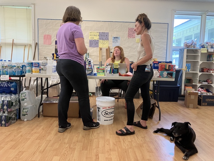
“The opioid epidemic has destroyed a lot of familial connections,” said Meghan Wayland on Monday afternoon while organizing donated food and cleaning supplies at the NEKO Depot, located in the back rooms of the Orleans Federated Church in Orleans Village. That’s where Northeast Kingdom Organizing set up its own resource center and communication hub within days of the flooding.
NEKO was born out of a collaboration among regional churches, the Caledonia Grange and the Center for Agricultural Economy in Hardwick, starting in 2017. The Orleans church was not one of the original organizations, but supporting the mutual aid group’s mission by opening up its space is an outgrowth of faith, said minister Alyssa May.
Minister Alyssa May speaks with NEKO lead organizer Megan Wayland and NEKO board member Ally Howell at the NEKO Depot in the Orleans Federated Church. Polly, Wayland’s dog, takes a snooze. Photo by Kristen Fountain/VTDigger
The group has been building relationships with people in the most affected communities for more than four years, said Ally Howell, who works for the agricultural nonprofit and is part of the NEKO leadership team.
“We were positioned really well to respond quickly in Barton and Glover and Orleans,” Howell said.
They began checking in with the families they knew as soon as roads were passable, and are trying to be in continuous touch and to understand their goals and needs, said Wayland, who is NEKO’s lead organizer and its primary eyes and ears on the ground.
“It may not look devastating. The pictures are not catastrophic,” they said on Thursday afternoon. “But we live in a region where people have already been on a tightrope. These people are living in low-lying areas and they have been clobbered by this thing.”
‘A delicate dance’
In Hardwick, the leaders of The Civic Standard, a nonprofit operating out of the former Hardwick Gazette building in the village, have been doing similar things. They mobilized volunteers to staff an emergency shelter that opened afternoon June 10, the first night of flooding there.
They also say the work is made possible by the presence The Civic Standard has been building in town for over a year. The group’s purpose, as described by co-founder Tara Reese, is simple but profound: “for people to be seen, to no longer be invisible to each other because of their differences,” she said.
A resource center, set up by The Civic Standard and the Hardwick Neighbor to Neighbor group, opened on the following Monday at the Hardwick Senior Center. By Wednesday morning, it had already given out all its dehumidifiers and more than 30 fans, and provided other kinds of support to 20 families, said volunteer Sarah Behrsing, who was staffing it then.
“It’s something we’ve been building on all the time anyway,” said co-founder Rose Friedman. The organization wasn’t founded to respond to a disaster, but it is able to fill that role because of connections it has made. Supporting a community is varied. “Sometimes that looks like disaster relief and sometimes it looks like trivia (night),” she said.
Other, older nonprofits are also playing a role. Thompson, the Greensboro Bend shopkeeper, said the Greensboro Association has provided funds for immediate assistance to local families. One family might need nights in a hotel; another one, help with material disposal.
“Going to the garbage is not cheap,” she said. “It’s definitely heartbreaking to see families who don’t have the means and resources.”
Having Wayland and other NEKO staff on the ground in affected communities has been invaluable in helping the state and regional groups understand community needs, said NEKCA’s Winterson. “They have been huge in that regard,” he said.
Mitchell said that, because of Wayland’s work, he is trying to coordinate deliveries to specific households by the Salvation Army’s van while it is in Barton.
NEKO is currently trying to bring materials and volunteers, while respecting residents’ wishes, to seven locations — and more are being added as they are found, Wayland said. The greatest need right now for the group are people in the trades and restoration professions who can help residents evaluate what is salvageable and what is not, they said.
“We need people who have done this before. We can’t order the dumpsters and leave people to coordinate the volunteers,” Wayland said. “We have a relationship; we don’t have the expertise.”
The Civic Standard group is working at three locations currently and matching volunteers at a few other locations, said Friedman on Thursday. It already has sufficient volunteers connected currently, and the work is not about ripping and tearing.
“People are still living in these houses and have a life in them and a lot of attachment to the things in them,” Reese said. At the Gazette building, they are also providing a quiet place where people can come to sit and talk.
Both NEKO and The Civic Standard know that they cannot solve every problem many of these households face. They can’t even make sure this doesn’t happen again.
“We can’t lift these houses out of a floodplain,” said Hardwick resident Helen Sherr, a summer fellow with The Civic Standard.
But people active in those organizations, as well as town officials, hope this long-term and difficult work —- which Friedman calls a “delicate dance” — will allow information and assistance to come more easily next time.
“I love these people. I grew up here. I want to help them look to the future,” Barton’s Atwood said. “I’m not naive enough to think this is the only time we are going to see this kind of water.”
Asistencia a familias afectadas por inundaciones en Kannapolis
Luego de casi un mes de ocurrida la inundación, algunas familias pudieron regresar a sus casas pero necesitarán repararlas, mientras que otras deberán encontrar un nuevo lugar para vivir debido a las condiciones en que quedaron sus hogares.