Old nightmares and new dreams mark the year since Kentucky’s devastating flood

The dream that haunts Christine White is always the same, and though it comes less frequently, it isn’t any less terrifying. 

The black water comes rushing at the witching hour, barrelling toward her front door in Lost Creek, Kentucky. She’s outside, getting her grandson’s toys out of the yard. It hits her in the neck and knocks her off her feet before racing down a street that has become a vengeful river. She and her husband run to a hillside and scramble upward, grabbing hold of tree roots and branches. She finds her neighbors huddled at the top of the hill. As dawn comes, everything is unrecognizable, the land shifted, houses torn from foundations. They begin to walk through the trees, over the strip mine, out of the forest, in their pajamas and underwear with whatever they were able to carry when they fled. 

Then she wakes up.

That night used to replay every time White went to sleep. She started taking antidepressants six months ago, something she felt ashamed of at first but doesn’t anymore. They’ve helped a little, but the dream still haunts her, lightning-seared and vivid. 

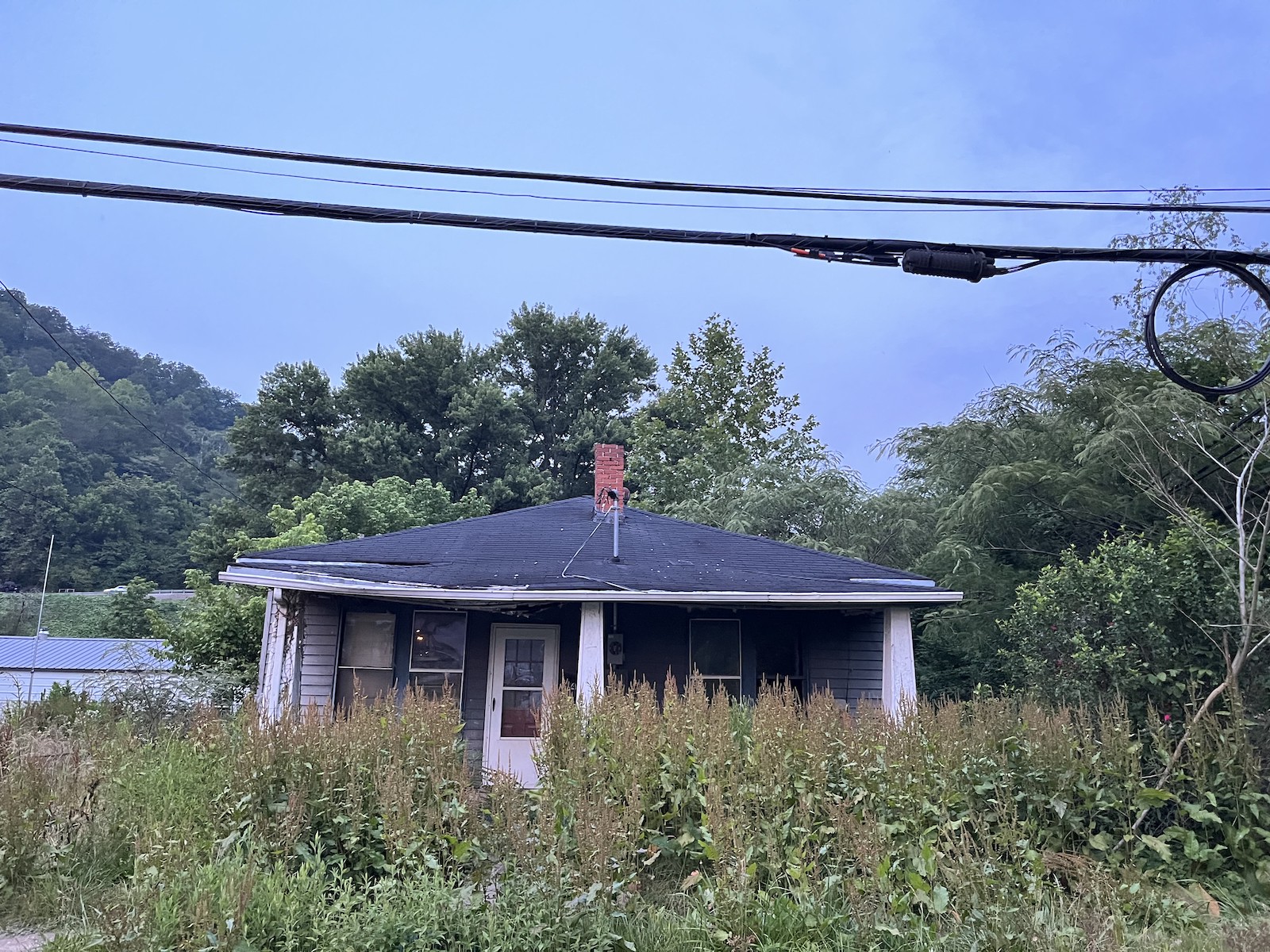
It’s been one year since catastrophic floods devastated eastern Kentucky, taking White’s home and 9,000 or so others with it. Her current abode — a camper on a cousin’s land — has become, if not home, no longer strange. But it’s the closest thing to home she’ll get till her new house, in another county, is finished. Lost Creek, though, is all but gone forever. What houses remain are empty husks. Some are nothing more than foundations overgrown with grass. 

White is never going back. “All the land is gone,” she said.

a woman in a colorful dress sits in front of a red structure
Christine White poses for a photo in Eastern Kentucky, one year after floods destroyed her home. Grist / Katie Myers

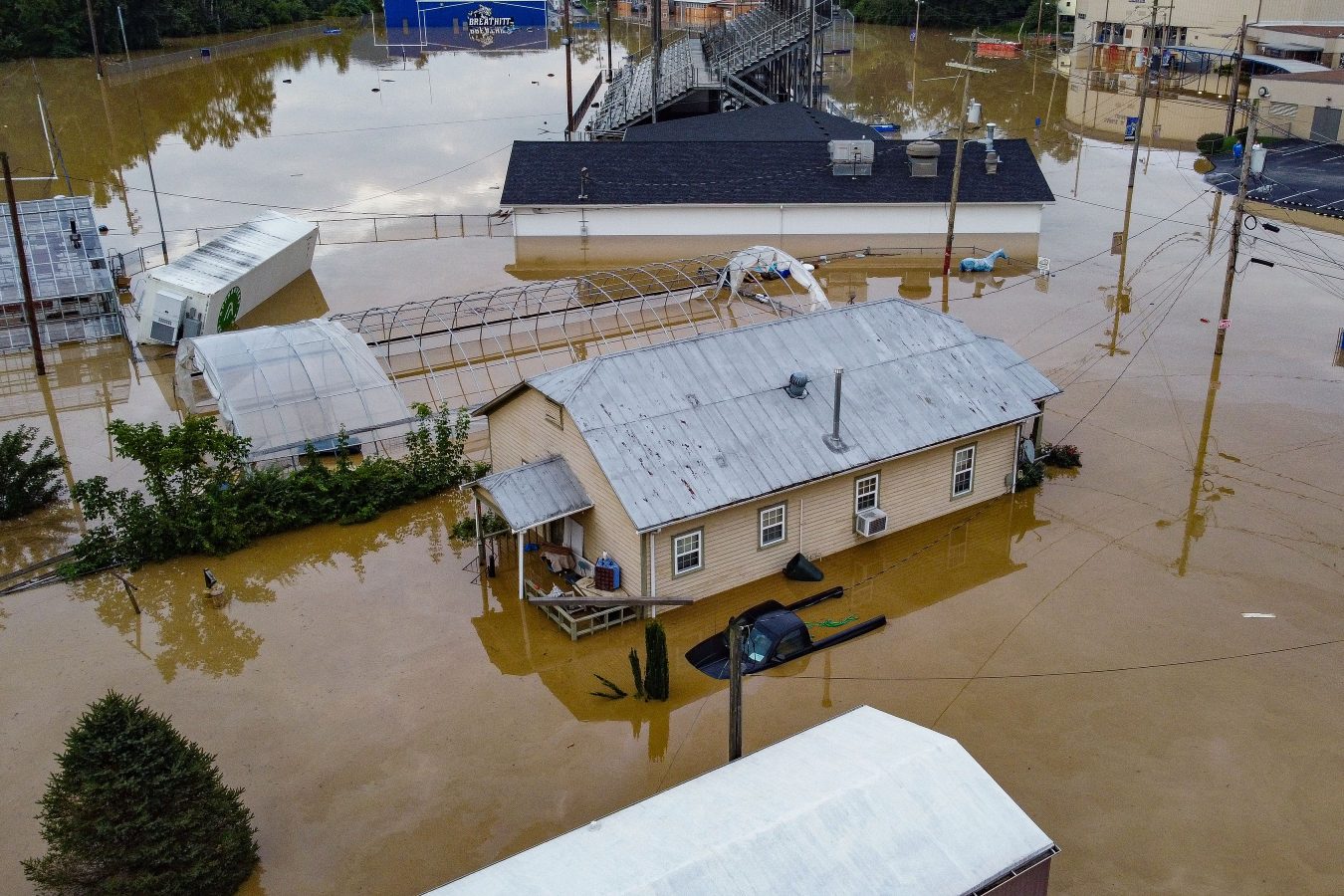
In the early hours of July 28, 2022, creeks and rivers across 13 counties in eastern Kentucky overran their banks, filled by a month’s worth of rain that fell in a matter of days The water crested 14 feet above flood stage in some places, shattering records. All told, 44 people died and some 22,000 people saw their homes damaged —staggering figures in a region where some counties have fewer than 20,000 residents. Officially, the inundation destroyed nearly 600 homes and severely damaged 6,000 more. A lot of folks say that tally is low, based on the number of residents who sought help from the Federal Emergency Management Agency. As of March about 8,000 applications for housing assistance had been approved. That’s half the number the agency received. 

The need for help, specifically housing assistance, was, and remains, acute. Most people here live on less than $30,000 a year, and at the time of the disaster, no more than 5 percent had flood insurance. Multitudes of nonprofits, church and community organizations, businesses, and government agencies have spent months pitching in as best they can. Yet there is a feeling among the survivors that no one’s at the rudder, and it’s everyone for themselves.

President Biden issued a federal disaster declaration the day after the flood, and his administration has disbursed nearly $300 million in aid so far. The state pitched in, too, housing 360 families in trailers parked alongside those from FEMA. Many of those have moved on to more permanent housing, but up to 1,800 are still awaiting a solution.

Some in the floodplains are taking buyouts — selling their homes to the federal government, which will essentially make the land a permanent greenspace. It’s a form of managed retreat, a ceding of the terrain to a changing climate. Some local officials openly worry that the approach doesn’t solve the biggest problem everyone faces: figuring out where on Earth people are going to live now. Eastern Kentucky was grappling with a critical shortage of housing even before the flood, and much of the land available for construction lies in flood-prone river bottoms. That has people looking toward the mountaintops leveled by strip mining.

a house with weeds
A vacant building in Whitesbury, Kentucky, one year after floods devastated the Eastern part of the state.
Grist / Katie Myers

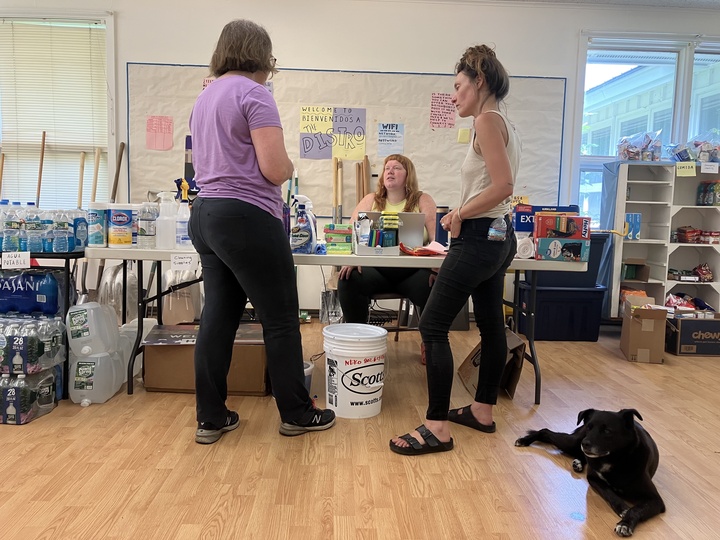
Kate Clemons, who runs a nonprofit meal service called Roscoe’s Daughter, sees this crisis every day. As the water receded, she started serving hot meals in the town of Hindman a few nights each week, on her own dime. She figured it would be a months’ work. She’s still feeding as many as 700 hungry people every week. Recently, an apartment building in Hazard burned down, displacing nearly 40 people. Some of them were flood survivors. They’ve joined the others she’s taken to helping find homes.

“There’s no housing available for them,” she said.


Clemons often brings food to Sasha Gibson, who after the flood moved with her boyfriend and nine children into two campers at Mine Made Adventure Park in Knott County. At first, she felt optimistic. “I was hoping that this would open up a new door to something better,” she said, after asking her children to go to the other trailer so she could sit for the interview in her cramped quarters. “Like this is supposed to be a new chapter in our lives.”

But the park, built on what was once a strip mine, became purgatory instead. 

Sasha Gibson, left, moved with her boyfriend and nine children into two campers at Mine Made Adventure Park in Knott County. Parker Hobson

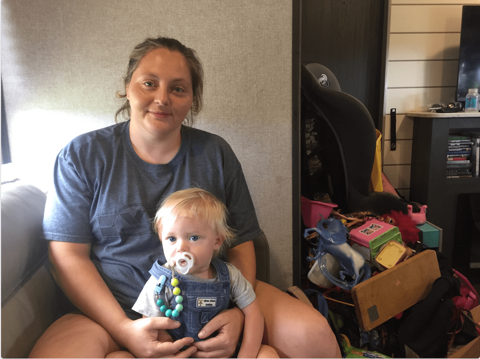
Gibson, who lived on family land before the rains came, wants to leave. It’s just that the way out isn’t apparent yet. Many rentals won’t take so big a family. It doesn’t help that many of their identity documents were lost to the flood, making the search that much harder. She got some help from FEMA, but said the money went too quickly. 

A caseworker helps navigate a labyrinth of agencies designed to help Kentucky flood victims, and they’ve put in applications at a grab bag of charities building housing. One has told Gibson her case looks promising, but she’s still waiting to hear a final word. Other applications are so long and such a crapshoot — one ran 40 pages, for a loan she’d struggle to pay back — that she’s too tired to put them together.

“It’s a big what-if game,” she said. “They’re not reaching out to you. You’re expected to call them.”

Meanwhile, ATV riders sometimes ride through to the park, kicking up dust and leaving a mess in the restrooms. Gibson tries not to resent them. It’s not their fault she’s stuck.

“While it’s great and, like, they’re having a good time, it’s not a great time for us because we feel like we’re stuck here and we’re, like, an inconvenience and we’re in the way,” she said. “We don’t want to bother anybody.”

As extreme weather intensifies due to climate change, stories like Gibson’s will play out in more and more communities. Though eastern Kentucky hadn’t flooded like this since 1957, parts of the state could face 100-year floods every 25 years or so. About half of all homes in the region hit hardest by last year’s floods — Knott, Letcher, Perry, and Breathitt counties — are at risk for extreme flooding. 

Some residents worry that the legacies of surface mining – lost topsoil and tree cover, a ruined water table, and waste retention dams like the one that may have failed near Lost Creek, drowning it – will make communities more vulnerable to floods, compounding the effects of generational poverty and aging rural infrastructure. Housing needs to be built, and some say it needs to go up on the only high, flat land available — that is, the very same strip mines that contributed mightily to this whole problem in the first place.

High ground, especially former strip mines, in the region tends to be off limits. A study completed in the 1970s showed that most of what is available belongs to land companies, coal companies, and other private interests. About 1.5 million acres is believed to have been mined. Many of those sites are too remote to be of much use for housing, though, and those that are closer to town typically have seen commercial development. As the flood recovery has dragged on, though, some of these entities have decided to donate some of what they hold so that there might be more residential construction. Other parcels have been donated by landowning families with cozy relationships to the coal industry, though that hasn’t always gone smoothly.

Chris Doll is vice president of the Housing Development Alliance, a nonprofit dedicated to building single-family homes for low-income families. It was beating the drum of eastern Kentucky’s crisis long before the flood. The situation is even more dire now. Without an influx of new construction, he argues, the local economy will spiral even further.  

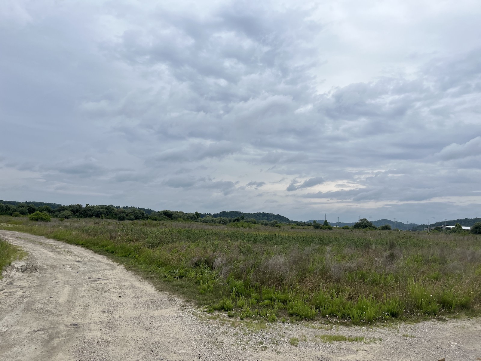
On an overcast and gentle day in June, Doll walked around a former strip mine turned planned development in Knott County called Chestnut Ridge. It sits near a four-lane highway and close to other communities, with ready access to water lines. The Alliance is working with other nonprofits to build around 50 houses here, along with, it hopes, 50 to 150 more on each of two similar sites in neighboring counties. A $13 million state flood relief fund has committed $1 million to the projects.  

a man in a t shirt and khakis in a field
Chris Doll stands in a field in Eastern Kentucky.
Grist / Katie Myers

The road leading to what could, in just a few years, be a bustling neighborhood opened up into a bafflingly flat landscape, almost like a wooded savanna. It was wide open to the sunshine, unlike the deep hollers and coves that characterize this part of eastern Kentucky. To an untrained eye, it appeared to be a healthy ecosystem. Look closer, though, and one sees the mix of vegetation coal companies use to restore the land: invasive autumn olive, scrubby pine trees, and tall grasses, planted mostly for erosion control.  

Still, it’s ideal land for housing, and most folks around here won’t mind the landscaping. Doll said the number of people who need help is overwhelming, and his team can’t help everybody. But they hope to build as many houses as they can.

“There are so many people that have so many needs that I am of the mindset that I will help the person in front of me,” Doll said. “And now we can turn them into homeowners. If that’s what they want.”

On a hillside overlooking another mine site, Doll and I walked up to the ridge to see if we could get a better view of the terrain. It is covered in a thicket of brush, too dense to see beyond. The path wound toward a small clearing, where worn headstones and stone angels sit undisturbed. Family cemeteries are protected from strip mining, and this one was clearly still cared for; the bouquets at the angels’ feet were fresh. The lifecycle of coal had come and made its mark and gone. 

Chestnut ridge is a former strip mine turned planned development in Knott County, Kentucky. Grist / Katie Myers

“You can see where they cut out,” Doll said. “They just entirely destroyed that mountain. It’s such a wild thing to think that strip mine land is going to be part of the solution.” 

Doll thinks of it as a post-apocalyptic landscape, or maybe mid-apocalyptic, ripe for renewal, but still carrying the weight of its past. The land was gifted by people whose money was made from coal, after all.

“And, you know, it’s great that they’re giving land back,” he said. “I would prefer if it was still mountains, but if it was mountains, we couldn’t build houses on it. So yeah, it’s ridiculously complex.” He shrugged.  “Bigger heads than mine.”

He squelched across the mud and back to the car. In the summer heat, two turkeys retreated into the shade of a scrubby pine grove, their tracks etched in the mud alongside hoofprints, probably from deer and elk. The place was alive, if not exactly the way it was before.  


The former strip mine developments are financed in part by the Team Kentucky flood relief fund created by the governor’s office. Beyond the four projects already in motion, eastern Kentucky housing nonprofits like the Housing Development Alliance are working with landowners, local officials and the governor to secure more land in hopes of building hundreds more homes. 

“Working together – and living for one another – we’ve weathered this devastating storm,” Governor Andy Beshear said last week during a press conference outlining progress made since the flood. “Now, a year later, we see the promise of a brighter future, one with safer homes and communities as well as new investments and opportunities.”

That said, nothing is fully promised just yet, and the process could take years. The homes will be owner-occupied and residents will carry a mortgage, but housing advocates hope to lower as many barriers to ownership as possible and help families with grants and loans. Applications for the developments are expected to open within a couple of months. The plans, thus far, call for an “Appalachian look and feel” that combines an old-style coal camp town and a suburban subdivision to create single-family homes clustered in wooded hollers. Though some might argue that density should be the priority, local housing nonprofits want developments that feel like home to people used to having a bit of land for themselves. 

The Housing Development Alliance has built houses on mined land before, and some of them are among those given to 12 flood survivors thus far. Alongside other entities, it has also spent the year mucking, gutting, and repairing salvageable homes, often upgrading them with flood-safe building protocols.  Even that comparatively small number was made possible through support from a hodgepodge of local and regional nonprofits, and the labor of the Alliance’s carpenters has been supplanted with volunteer help. 

Though the Knott County Sportsplex, a recreation center built on the mineland next to Chestnut Ridge, appears to be sinking and cracking a bit, Doll said houses are too light to cause that kind of trouble.  Nonetheless, geotechnical engineers from the University of Kentucky, he said, are studying the land to make sure there won’t be any unpleasant surprises. The plan is for the neighborhoods to be mapped out onto the landscape with roads and sewer lines and streetlights, all of which require the involvement of myriad county departments and private companies; then the Alliance and its partners will come in and do what they do best, ideally as further disaster funding comes down the line. 

Still, all involved say that there’s no way they can build enough houses to fill the need.

A flood-damaged building sits vacant in Lost Creek, Kentucky
A flood-damaged building sits vacant in Lost Creek, Kentucky.
Grist / Katie Myers

More federal funding will arrive soon through the U.S. Housing and Urban Development disaster relief block grant program. It allocated $300 million to the region, and organizations like the Kentucky River Area Development District are gathering the information needed to prove to the feds the scale of the region’s need. Some housing advocates are critical of this process, though. 

Noah Patton, a senior policy analyst with the Low-Income Housing Coalition, said HUD grants are too unpredictable to forge long-term plans. “One reason it’s exceptionally complicated is because it is not permanently authorized,” he said. A president can declare a disaster and direct the agency to release funds, but Congress must approve the disbursement. Although it all went smoothly in Kentucky’s case, the unpredictability means there are no standing rules on how to allocate and spend funding.

“Oftentimes, you’re kind of starting from scratch every time there’s a disaster,” Patton said.  

Local development districts, such as the Kentucky River Area Development District, are holding meetings around the affected counties, urging people to fill out surveys so it can collect the data needed to apply for funding from the federal program. And HUD is overhauling its efforts to address criticism of unequal distribution of funds. Still, the people who might benefit from these block grants may not see the homes they’ll underwrite go up for a few more years, Patton said. 

On the state level, housing advocates have been pushing the legislature for more money to flow toward permanent housing. Many also say the combined state, FEMA and HUD assistance isn’t nearly enough. One analysis by Eric Dixon of the Ohio River Valley Institute, a nonprofit think tank, pegged the cost of a complete recovery at around $453 million for a “rebuild where we were” approach and more than $957 million to incorporate climate-resilient building techniques and, where necessary, move people to higher ground.

Sasha Gibson has heard rumors of the new developments. She’s somewhat interested insofar as they can get her out of limbo. Until she sees these houses going up, though, they’ll be just another vague promise in a year of vague promises that have gotten her nowhere but a dusty ATV park. It’s been, to put it bluntly, a terrible year, and the moments where the family’s had hope have only made the letdowns feel worse. 

 “I have no hope to rely on other people,”  she said. “I don’t want to give somebody else that much power over me. Because then you’ll just wind up disappointed and sad. And it’s even sadder when you have all of these little eyes looking at you.”


As Gibson waits, others long ago decided to remain where they were and rebuild either because they could or because there wasn’t another choice. 

Tony Potter, who’s lived on family land in the city of Fleming-Neon since birth, has spent the past year in what amounts to a tool shed. It’s cramped and doesn’t even have a sink, but the land under it belongs to him, not a landlord or bank. It’s a piece of the world that he owns, and because a monthly disability check is his only income, he doesn’t have much else and probably couldn’t afford a mortgage or rent. Asked if he’d consider moving, he scoffed.

“You put yourself in my shoes,” he said. 

a man with tattoos sits on steps
Tony Potter, who’s lived on family land in the city of Fleming-Neon since birth, says he won’t consider leaving. Grist / Katie Myers

He can’t believe FEMA would offer to buy someone’s land, or that anyone would take the government up on the offer. “I mean, my God, why in the hell you wanna buy the property and then tell them they can’t live on it?” he said. “What kind of fool would sell their property? Why would you want to sell something and then go rent something?”

James Hall, who also lives in Neon, lost everything but is staying put, in part because he doesn’t think it’ll happen again. The words “thousand-year flood” must mean something, he said. But that didn’t keep him from putting his new trailer a foot and a half higher just in case. He might bump that up to 3 feet when he has a minute. Through it all, he’s kept his dry sense of humor. “If the flood comes again,” he said, “I’m gonna get me a houseboat.”

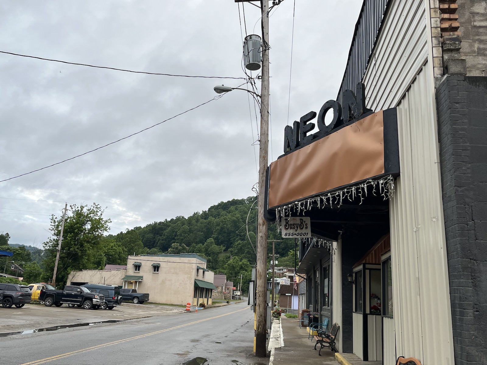
That kind of outlook buoys Ricky Burke, the town’s mayor. He said the community’s used to flooding – the city sits in a floodplain at the intersection of the Wrights Fork and Yonta Fork creeks – but last year’s was by far the worst. Water and mud plowed through town with enough force to shatter windows. People went without water and electricity for months in some places. A few buildings, like the burger drive-in on the corner at the edge of town, have been repaired, but others remain gaunt and empty. 

Still, Burke, a diesel mechanic who was elected in November, is confident the town will pick itself up. He’s heard talk that Neon might need to move some of its buildings, that a return to form simply isn’t viable. He’s dismissive of such a notion. What Neon needs, he believes, is a big party, and he’s planning to celebrate the community’s resilience with flowers, music, and a gathering on the anniversary of the flood.

“These people in Neon ain’t going nowhere,” he said.

a sign says neon above an awning
A sign hangs above Neon’s main street.
Grist / Katie Myers

Some folks, through persistence, hard work, and a bit of luck, have moved into new homes.

Linda and Danny Smith got theirs from Christian Aid Ministries, a Mennonite disaster relief group, though construction started a couple months later than planned because it ended up taking awhile to figure out exactly where the floodplain was. It was built on their land at the end of a Knott County road called, whimsically, Star Wars Way. According to the Smiths, the group, which was from out of state, nearly ran out of time before having to return home and only just finished the job before leaving. They left so quickly that Danny Smith said he still needed to paint the doors. He isn’t complaining, though. Other homes were left half-done, their new owners left searching high and low for someone to finish the job. 

Although grateful for the help that put a roof over his head, Smith got a little tired of dealing with all the people who came to heal his body, his spirit, and his mind even as he completed mounds of paperwork and made calls to anyone he thought might help. “One guy, he kept insisting that I needed to go talk to someone,” he recalled. “And I said ‘who?’”

a man in woman stand in a kitchen
Linda and Danny Smith stand in the kitchen of their new home. Parker Hobson

The man suggested that Danny talk to a therapist. He laughed at the recollection. It was a laugh heard often around here, the sound of a tired survivor who’s already assessed their own hierarchy of needs many times over. “I said, ‘You know, I don’t need nothing done with my mind. I need a home.”

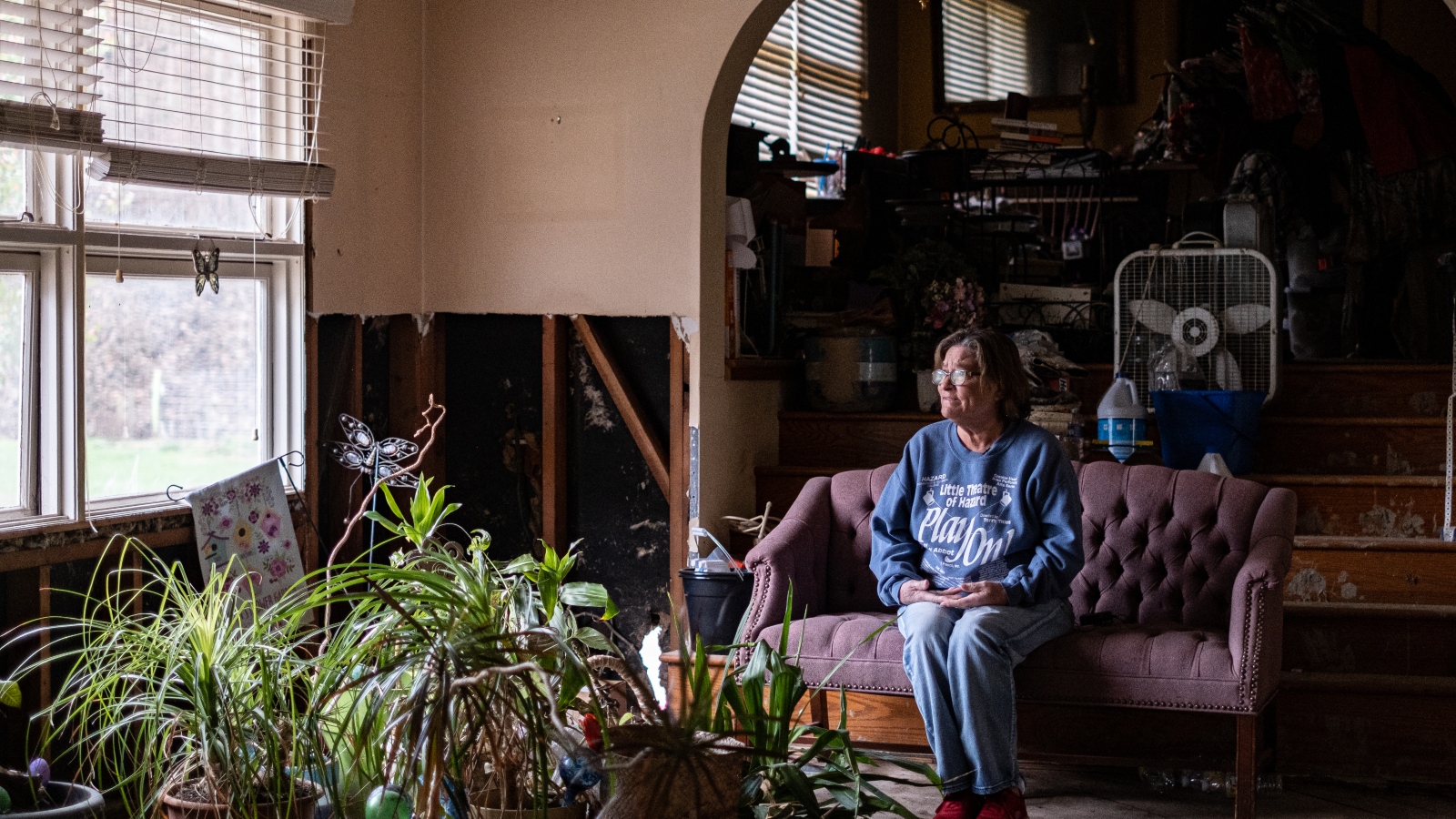
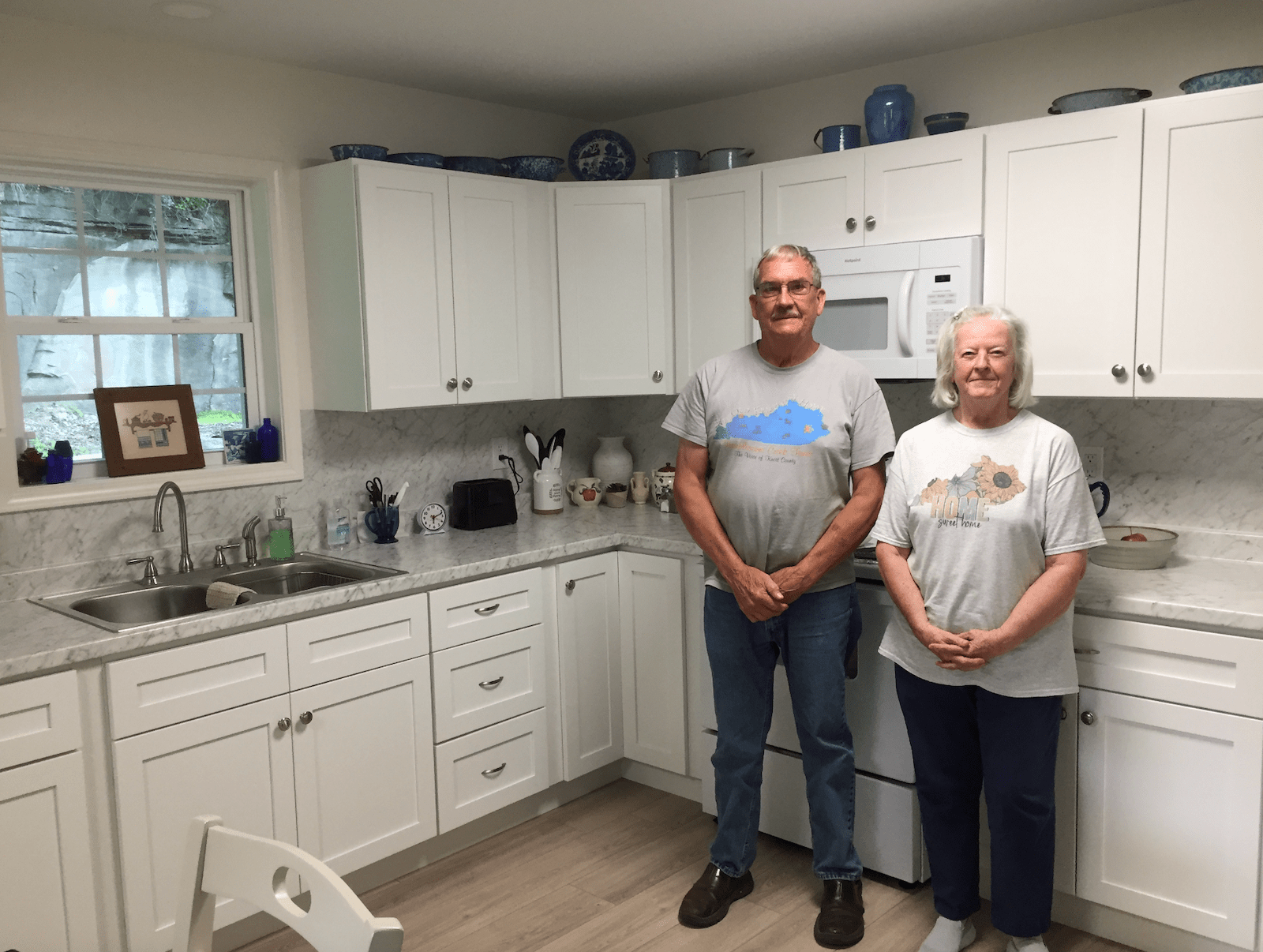
Despite the frustration, the Smiths are piecing their lives back together, a little bit higher up off the ground than they were before. Christine White is praying for a similar outcome, and thinks she can finally see it on the horizon. The occasional nightmare aside, she’s felt pretty good these days.

FEMA gave her $1,900 awhile back to demolish her house and closed her case, leaving her high and dry. She called housing organization after housing organization until CORE, a national nonprofit that assists underserved communities, agreed to build a small home on a piece of land she owns in Floyd County. Construction began earlier this month. White, who spends her time volunteering at a local food bank, calls it a miracle. “You just gotta go where the Lord leads you,” she says. But it’s not built yet, so she’s trying not to count her chickens.

Parker Hobson contributed to this story.

This story was originally published by Grist with the headline Old nightmares and new dreams mark the year since Kentucky’s devastating flood on Jul 27, 2023.

‘Path of the Pronghorn’ bottleneck leased for development at $19/acre

Judith and Matthew Thompson have watched countless pronghorn hoof it over the frozen New Fork River on the parcel of state land adjacent to their home. 

“The best migration that you could watch comes through that section,” Matthew Thompson said. “It does bottleneck them, and they’ve probably been doing it for 10,000 years right there.” 

Sometimes they’re inspired to record photos and videos of the trails left by massive herds on the go. Last winter, Judith Thompson pulled out her phone to call the Wyoming Game and Fish Department and inquire what to do about a doe pronghorn dying in view of her home. 

Judith Thompson, who splits time between Wilson and Sublette County, poses where hundreds of pronghorn crossed over the frozen New Fork River on state land adjacent to her home. (Courtesy)

On Monday, she pulled out her phone once more, this time to text WyoFile her thoughts about the potential oil and gas development that might be going in one lot over, on the section of Wyoming-owned land right where the pronghorn tend to push through.

“It really sucks,” Judith Thompson wrote. “I’m floored that the state would deem this particular piece of land as to be so vital to the state coffers that they would sacrifice a national treasure for what would be a pittance of their budget.” 

Unbeknownst to the Thompsons until Monday, the rights to drill for oil and gas on the 640-acre parcel abutting their property — part of Wyoming’s school trust land system — had been auctioned off 12 days prior at a Wyoming Office of State Lands and Investments lease sale. The winning bid came in at $19/acre, for a total cost of $13,170 including fees. The company that placed the winning bid has not yet been identified and will remain unnamed until auction documents are published online Thursday, according to Diana Wolvin, an OSLI employee. 

Environmental groups aren’t waiting to learn the lease holder’s name before lambasting the state for greenlighting oil and gas leases in a particularly vulnerable segment of the Path of the Pronghorn, right where migratory herds come off the Pinedale Mesa and cross the New Fork River. 

“This winter was devastating on the Sublette pronghorn herd [and] the last thing these remaining animals need is another obstacle in their way during their seasonal migrations,” Nick Dobric, the Wilderness Society’s Wyoming conservation manager, wrote to WyoFile in an email. “We’ve had good data on this migration for well over a decade, so the state’s continuing inaction to recognize and manage the Path of the Pronghorn is careless.”

The Wyoming Office of State Lands and Investments leased several tracts of school trust land within the undesignated migration corridor of the Sublette Pronghorn Herd during its July 12 lease sale. Conservation groups are especially concerned about parcel 194, which is overlaps an antelope thoroughfare used by animals crossing the New Fork River. (Mackenzie Bosher, The Wilderness Society. Sources: Energy Net, Esri, USGS.)

Meghan Riley, a public lands and wildlife advocate for the Wyoming Outdoor Council, called Wyoming’s lack of a system to “catch these conflicts” where migration routes haven’t yet been designated “disappointing.”

“Everybody knows these guys got hammered,” Riley said, “and it’s sad to see threats and pressure coming from so many different directions.”  

Four-year delay

Wyoming does have a migration policy that is designed to avert such conflicts, but it hasn’t been used in years.

The celebrated Path of the Pronghorn — AKA, the Sublette Pronghorn Herd migration — includes animals that migrate all the way to Grand Teton National Park and right by Thompson’s backdoor. Although it’s the next migration corridor in the queue to be designated, according to the Wyoming Game and Fish Department, the Path of the Pronghorn has stayed in that on-deck space for more than four years. Proposed protection of the route was paused in 2019, when an alliance of industry groups successfully pressured the state to overhaul how it nominates and designates migration corridors. 

No migration corridor has been designated, or received protections since, though the four-year delay may be nearing its end. 

Coming soon is a Wyoming Game and Fish Department “threat analysis” that will recommend whether the Sublette Pronghorn Herd migration needs to be designated or not, according to deputy director Angi Bruce. 

“I think we’re a few months out,” Bruce said. “Once we review [the threat analysis], we’ll decide where we go. That’ll be taken to our commission at a future commission meeting for their direction and guidance.” 

A group of pronghorn trots through the snow in the Green River Basin in April 2023. (Mike Koshmrl/WyoFile)

Wyoming’s migration policy stems from a gubernatorial executive order that lets the governor call the shots. The state’s current chief executive, Gov. Mark Gordon, has downplayed designating the Path of the Pronghorn. At a Pinedale meeting about severe wildlife winterkill in March, he heard calls to make the designation.

“Our pronghorn cannot wait another minute,” Upper Green River Alliance Director Linda Baker told Gordon. “Please do it now.” 

In response, the governor called for a “durable” solution that transcends political swings and changes in federal land management policy. 

“Drawing a line on a map is not going to fix that,” Gordon said. Instead, he said, a “committed” coalition of private landowners, local agencies and the public is needed to make the “migration corridor work.”

Bitter winter, encroaching development

The Sublette Pronghorn Herd has had a rough couple years. 

Based on GPS collar data being amassed to guide a prospective designation, roughly 75% of the formerly 43,000-animal herd died last winter, casualties of an unusual, inverted low-elevation snowpack and a mycoplasma bovis outbreak. Every collared animal that trekked all the way from the Green River Basin to Grand Teton National Park perished, though the Jackson Hole News&Guide has since reported that park biologists have anecdotally observed “at least 25” pronghorn that made the journey.

The carcasses of 16 pronghorn are clustered on a hill overlooking Highway 191 south of Boulder in May 2023. (Mike Koshmrl/WyoFile)

Meanwhile, the herd’s habitat is being slashed. Encroachments on the migration include private land subdivisions exempted from the state’s policy and a Lower Valley Energy gas pipeline that’s going in

Immediately south of the state parcel just leased, Sotheby’s real estate has listed 80 acres for those “looking for serenity, solace and a sense of wide open spaces” to build their “dream home getaway” — price tag $700,000. 

The lot just south of Wyoming’s school trust section along Paradise Road is on the market for $700,000. (Mike Koshmrl/WyoFile)

At a July 7 forum on conserving ungulate migration, University of California-Berkeley researcher Arthur Middleton spoke to the confluence of development forces that are coming to places like the Greater Yellowstone Ecosystem. (Disclosure: Middleton is married to WyoFile board member Anna Sale.)

“These parks attract development,” Middleton said. “They attract development that undermines their own selves. Remote work, COVID, TV shows like Yellowstone — seriously — these are driving a wave of development pressure that’s hitting this place, and it’s going to be very severe, I think.”  

Arthur Middleton speaks at the inaugural gathering of the Global Initiative on Ungulate Migration in July 2023. (Mike Koshmrl/WyoFile)

Yet other threats to the Sublette Pronghorn Herd’s travel paths loom. 

Jonah Energy’s $17 billion Normally Pressured Lance gas field carves through the southern reaches of the yet-to-be designated Path of the Pronghorn. An attorney for Wyoming contended the gas field and migration corridor didn’t overlap during oral arguments this spring in a case about pronghorn impacts before the 10th Circuit Court of Appeals, but was criticized by one biologist for “doing a deliberate mislead.”

Research found the decades-old Pinedale Anticline field caused Sublette pronghorn to avoid and even abandon altered parts of the landscape after collaborative efforts to create a pronghorn-friendly gas field fell apart

Pronghorn protections precluded

Wyoming’s migration policy calls for state agencies to “maintain habitat and limit future disturbance.” Infrastructure like gas pads are to be located  within already disturbed or biologically unsuitable areas if they must occur within a designated corridor, the policy states. 

Even without a designation, Wyoming Game and Fish could have recommended pronghorn protections when it vetted the state’s lease sale, said Bruce, the agency’s deputy director. 

“A lot of people think we need a designation to use our data — if that were the case, we would have spent the last 50 years not using our data,” she said. “The data is the data, and we use it all the time in our operations, our commenting and our reviews.” 

Via a letter and spreadsheet, Game and Fish did ask that some wildlife stipulations be attached to parcel 194, the New Fork River tract leased for $19 an acre. 

Because of the state agency’s recommendation, there’s a stipulation for “big game crucial winter range” instructing developers to avoid human activity from Nov. 15 to April 30. Another stipulation will require that the winning bidder provides a 300-foot buffer from the New Fork River, while another is geared toward preventing the spread of aquatic invasive species. A stipulation that made it through subjects exploration and development activities to Wyoming’s sage grouse core area policy, which is in the process of being revised

Industrial equipment, including a battery of Ultra Resources tanks, are located on a section of school trust land where the state of Wyoming auctioned off an oil and gas lease for $19 an acre. (Mike Koshmrl/WyoFile)

But a stipulation for pronghorn migration didn’t make the cut for the parcel along the New Fork River. 

Will Schultz, Game and Fish’s habitat protection supervisor, said there are still opportunities via “micro-siting” techniques to diminish the impact of development that’s coming. It’s not like it’s an undisturbed parcel, he pointed out.

“If it can be sited in close proximity to current development, it might not have any more impact than the development that’s already there,” Schultz said. “Hopefully there can be some collocation.” 

Paradise Road, the New Fork River’s Remmick boat ramp and even a battery of Ultra Resources tanks from an earlier era of energy development are among existing developments on the school trust parcel. 

The potential for micro-siting near these disturbances isn’t enough to fully placate Dobric, the Wilderness Society staffer. 

“It’s irresponsible to lease or permit without adequate protections, like the state is proposing now, with what we know about this migration,” he said. “If Wyoming wants to continue to be a leader in big-game migration conservation and ensure our herds are able to rebound then the state needs to take decisive action formally recognizing these migrations.”

The New Fork River, as seen from the Remmick boat ramp. (Mike Koshmrl/WyoFile)

Based on publicly available pronghorn location data, the development rights just auctioned off almost assuredly would impact the landscape within the Sublette Pronghorn Herd’s migration corridor, Dobric said.

“There’s additional collar data out there that shows even more routes,” he said. “We’ve heard that the New Fork parcel is even more used than what’s shown already.”  

The Thompsons have seen it firsthand. Matthew Thompson thought back to fall of 2018, when the Roosevelt Fire raged in the Bondurant area to the north, seeming to facilitate an early migration.

“My painter and I watched thousands come through there,” Matthew Thompson said, “and it just blew his mind.”

Thompson on Monday seemed resigned about the fate of the state parcel next door. 

“We aren’t going to be able to stop it,” he said. 

But the Wyoming Outdoor Council’s Riley hasn’t given up the fight. She sent a protest letter to the State Board of Land Commissioners, which meets to review and finalize the sale on Aug. 3. 

“Biologists at the Wyoming Game and Fish Department have drawn on a massive dataset and put tremendous effort into understanding where these animals move on the landscape in preparation for a long-awaited process to officially identify this corridor, with a potential designation in the future,” Riley wrote. “We ask that parcel 194 be withdrawn until that can happen.”

Other neighbors along Paradise Road reached by WyoFile were less convinced that another gas pad or two would further harm the pronghorn migration coming off the Pinedale Mesa and crossing over New Fork River on the way to more southern sweeps of sagebrush. 

“I don’t want it to have an impact, but what’s the most important?” cattle rancher Vera Roberts said. 

Both pronghorn and oil and gas, she added, are “very important.” 

“So I don’t know,” Roberts said. 

The post ‘Path of the Pronghorn’ bottleneck leased for development at $19/acre appeared first on WyoFile.

Oklahomans are asked to mail in dead butterflies, moths in the name of science

Vermont was seen as a climate haven. This summer has complicated that image.

Vermont was seen as a climate haven. This summer has complicated that image.
Second Street in Barre on Wednesday, July 18, 2023 is lined with debris from last week’s flooding. Photo by Glenn Russell/VTDigger

In 2018, Zack Porter moved from Missoula, Montana, to Vermont.

Porter, the executive director of a small regional forest conservation nonprofit, grew up in New England but had lived in the West for about 15 years. As Western states endure hotter, dryer summers, however, Missoula has been increasingly smothered with smoke from nearby wildfires, and Porter and his wife grew worried about the health of their young daughter.

After “two back-to-back horrific smoke seasons,” he said, the family decided to pack up and move to Montpelier.

As the world warms, Vermont has been touted as a climate refuge, a place that has drawn people — like Porter and his family — who are seeking escape from the worst effects of climate change.

But this summer has forced Vermonters to reexamine that reputation. Unrelenting rainfall — a phenomenon exacerbated by climate change, experts say — earlier this month left Vermont’s capital and other towns underwater.

Before that, in late June, some parts of the state were in fact experiencing a moderate drought, according to the U.S. Drought Monitor. Meanwhile, smoke from Quebec wildfires has periodically poured into the state, triggering air quality alerts. And blooms of toxic cyanobacteria, which are linked to warmer water temperatures, have repeatedly closed beaches along Lake Champlain and been detected in other bodies of water, according to Vermont Department of Health data.

Porter’s house was spared from the flooding. But the destruction in downtown Montpelier reminded him of that wrought in the coastal South by Hurricane Katrina, he said. And the appearance of wildfire smoke — a factor that had driven them away from Montana — was “heartbreaking,” he said.

In the 12 years since Tropical Storm Irene struck the state, “This image of Vermont being this quiet, happy refuge really kind of took over again,” Porter said. “Vermont has a lot of things going for it. But we aren’t immune to natural disasters.”

‘Vermont was the best contender’

Vermont regularly appears at the top of lists of states best poised to weather global warming. The relatively cool climate makes the state more resistant to extreme heat waves, and with no coastline, residents need not worry about rising sea levels. Abundant, year-round precipitation insulates Vermonters from drought and water shortages.

Many recent arrivals, like Porter, have cited climate change as a reason for their move, according to Cheryl Morse, a professor of environmental studies and geography and geosciences at the University of Vermont.

“There’s a belief that Vermont will have enough water most of the time, that it will have a more temperate climate in terms of weather, in terms of temperature,” said Morse, who has studied migration into the state. “In their imagination, Vermont presented a safer climate with plenty of water, access to land and small community settlement.”

One such new arrival was Cymone Bedford. In 2020, Bedford moved to Vermont from Atlanta, Georgia, with the goal of building an eco-friendly home: She lives in Johnson, in an off-grid “Earthship,” a house designed for self-sufficiency and sustainability.

“I was thinking, like, where would I want to retire? Like, where would I want to live long-term, that I know if I plant roots and build community, I can comfortably stay there during climate change?” she said. “And based on my research, I felt like Vermont was the best contender.”

Bedford, a municipal planning director, did not suffer any damage personally in the recent flooding. Johnson as a whole, though, was hit hard by the rising Lamoille River: The grocery store was gutted, as were the Johnson Health Center and the town’s wastewater facility.

“Maybe some of the branding that Vermont is, you know, just like blanketly the best place for climate change will need to have some caveats,” Bedford said.

‘This summer has maybe burst the bubble’

Despite its reputation, Vermont is expected to face — or is already facing — a slew of unpleasant or dangerous phenomena linked to rising temperatures: flooding, heat waves, wildfire smoke, algae blooms, tick-borne diseases, according to Jared Ulmer, the climate and health program manager at the Vermont Department of Health.

“This summer has maybe burst the bubble a little bit in what probably was more of just a myth, of Vermont being in an ideal climate refuge,” Ulmer said.

This week, Morse, the UVM professor, sent a survey to about 25 recent arrivals in Vermont who have previously participated in her research, asking if the flooding or wildfire smoke had caused them to reconsider their move.

As of Monday morning, Morse had received responses from 17 people. Of those, six said that their homes or property had been personally affected by the flooding.

But only one respondent said the recent weather had caused her to question her relocation to Vermont.

“We’ve had a few days of really smoky weather, reminding us of living out West,” said the woman, who lives in northern Vermont, according to an anonymized response shared by Morse. “It’s been disappointing, we put a lot of time, effort and money into our move to VT with the hopes of getting away from some of these recent weather events.”

Every other person who responded to Morse’s survey said that they were happy to be living in Vermont.

“It is disappointing to have such a strange summer of rain and smoky air, but we also recognize how terrible it is in many other places,” said one Chittenden County man. “Vermont remains beautiful through it all and we will recover better than some areas.”

‘You can’t buy that’

Most people interviewed by VTDigger, including Bedford and Porter, the relatively recent arrivals, agreed that Vermont is still in a better position than most other states.

“In the largest sense, we’re probably safer than some other places: We’re wet, which on the whole is probably better than dry, and we’re far enough north that our worst heat waves will likely be mild compared with some,” Bill McKibben, an activist and Middlebury environmental studies professor, said in an email earlier this month.

When it comes to weathering natural disasters, many argue that Vermont’s best feature is more cultural than meteorological: the state’s social cohesion. The value placed on community and cooperation, some said, helped residents weather Covid-19 and is apparent in the outpouring of support after the flooding.

“I feel like there is a localism culture in Vermont that is mutually supportive and group-oriented,” said Bedford, the Johnson resident. “And you can’t buy that. You can’t even legislate that. It’s there or it’s not.”

Read the story on VTDigger here: Vermont was seen as a climate haven. This summer has complicated that image..

In rural Vermont, reaching residents with flood damage takes a village

In rural Vermont, reaching residents with flood damage takes a village
Inside the resource center organized by The Civic Standard and other groups at the Hardwick Senior Center, volunteer Sara Behrsing of Hardwick sorts through donations. Photo by Kristen Fountain/VTDigger

Kristin Atwood, the town clerk and treasurer in Barton, spent most of her waking hours last week subbing in as part of the town’s road crew. 

This week, she’s leading the municipal outreach to affected residents, trying to persuade neighbors she’s known since childhood to accept help recovering from the worst flooding to hit this small Orleans County town in living memory. 

As the only full-time town employee who’s not able to operate heavy machinery, Atwood took on the tasks of driving all the back roads to find washed-out sections and place orange cones around them, so that others could get to work fixing them, she said in an interview on Wednesday. 

That’s why, when representatives from the Federal Emergency Management Agency arrived at her office without warning the previous Saturday morning to visit residences damaged in last week’s historic flooding, the homes she knew of to show them were those of people who had posted pictures on social media, she said.

“I only got a call when people were outside my door,” Atwood said. “I didn’t have time to organize a list.”

With new Vermont counties added to the major disaster declaration Friday morning, Atwood hopes the federal assessors will come back to Barton. 

Going door to door on Monday and Tuesday, she’s found a lot for them to see — dozens of residences that were severely flooded in town, both on both the north and south side of Barton Village and in downtown Orleans Village.

In Barton, and other small towns across the state impacted by flooding, municipal officials and nonprofit groups are realizing that the people who may need the most help are often the least willing or able to reach out and request it. You have to talk to them, and even then they may not reveal the full extent of what they are facing. To know that, you have to visit and see for yourself.

In Glover, another Orleans County town, the new town administrator, Theresa Perron, coordinated with Glover Rescue volunteers and other townspeople late last week, trying to reach every affected household. At least 10 and likely “well over” suffered damage she called “extensive” to their living space, some of which she was able to show FEMA representatives. 

In addition to the door-knocking, Atwood has asked the owner and clerks at the nearby C&C Supermarket to try to engage anyone buying large amounts of cleanup supplies, such as garbage bags and bleach, to find out where they live. 

In Greensboro Bend — a village in the Orleans County town of Greensboro between Glover and Hardwick — Jen Thompson, who co-owns Smith’s Grocery with her husband, Brendan, is taking on that role. 

The store is up and running, although it took on water in the basement. Thompson is coordinating with another small business owner in Stannard who is trying to visit and check on every home. 

“A lot of people, particularly in these areas, do not have internet and social media,” Thompson said on Thursday. “I feel like the damage is out there and I feel like it is a lot more than we know. It’s just trying to figure out who they are.”

‘People don’t like to ask for help’

For town leaders and social service organizations, finding those most impacted by the flooding is only the first challenge. The second is getting them to agree to accept assistance from people outside of their immediate family and friends.

“People don’t like to ask for help. They think their issue is nothing compared to somebody else’s,” said Thompson.

Atwood echoed that sentiment. “Asking for help is hard, especially for a lot of Vermonters. It’s an independent group,” she said in an interview on Wednesday. 

When she visited, people smiled and shrugged and told her, “We made out fine” and “What can you do?” when she asked them how they were doing, she said. 

At that point, the people she spoke with hadn’t called 2-1-1, Vermont’s flood damage hotline, but they promised to do so once she explained that reporting damage could help their neighbors access federal funds. 

“Many of these houses are just over that line of acceptable” for safely living in, Atwood said. “A lot of the folks are older people used to doing for themselves and they are plugging away.”

Over the course of those two days, she gave out four dehumidifiers and 22 industrial-strength fans — everything that had been delivered the previous week to the town hall by the Vermont National Guard. 

She wasn’t sure on Wednesday morning how many would actually stop by the “Multi Agency Resource Center,” a gathering of state and regional resources that was going to be set up the following day beneath the town offices on Barton’s village square. If people heard about it, some would need to get a ride — many personal vehicles were damaged by flooding. 

two red cross vans parked in front of a brick building.
Salvation Army and Red Cross vehicles signal the location of the state’s Multi Agency Resource Center at the Barton Memorial Building. Photo by Kristen Fountain/VTDigger

On Thursday afternoon, a modest but steady stream of visitors was passing through the MARC, as it’s called by Vermont Emergency Management, in the basement of the Barton Memorial Building, which was flanked by large vehicles showing the logos of the Salvation Army and Red Cross. The pop-up center is scheduled to remain until 5 p.m. Saturday. 

Outside, most of the people were gathering to pick up cases of water and a bucket of cleaning supplies from the Salvation Army, and a hot meal of sauerkraut and kielbasa from the Red Cross. Nearby, staff from the Vermont Food Bank and Northeast Kingdom Community Action, or NEKCA, answered questions and distributed food boxes, diapers and flashlights.

The Vermont Department of Health also had a table there, with free water-testing kits available for those with household springs and wells, as well as informational flyers that outlined the risk and potential health impacts of mold growth and how to safely clean out your home following a flood. 

But several people had also made it inside to consult with the state Agency of Human Services about the loss of items purchased through the Three Squares food assistance program, said regional field representative Chris Mitchell. Nearby staff from the Department of Labor said they also had assisted a few people with information about unemployment insurance. 

Momentum seemed to be building throughout the day as people in and around Barton told each other about what was there, Mitchell said. He knows they need to do more than simply tell town officials and state representatives, and announce the pop-up center on social media.  

“We’re hoping word of mouth works,” Mitchell said. “We’re trying to spread the word.”

two people sitting at a table with laptops.
Cindy Grenier, a benefits program specialist with the Vermont Department of Children and Families, and Chris Mitchell, regional field supervisor with the Vermont Agency of Human Services at the AHS table inside the Barton Memorial Building. Photo by Kristen Fountain/VTDigger

NEKCA is also aware that personal outreach is essential, said Casey Winterson, the group’s director of economic and community services. That’s one reason the nonprofit purchased two mobile units of their own, so they could provide direct services outside their offices in Newport and St. Johnsbury. 

On Wednesday, his staff were in Groton, where they made contact with one family with young children who were without shelter and no longer able to stay in a campground that had been closed due to flooding, he said. 

‘We need to go to them’ 

Consistent engagement is needed to reach many of the residents of the Northeast Kingdom and other rural regions who need the most help to recover after the flooding, said town officials. 

These are households headed by elderly or disabled people, and those that have taken in extended families impacted by substance abuse, many including young children. Many could use a hand in clearing out the water and cleaning up what was left behind.

There were a few homes in Glover where cleanup appeared to be challenging the residents’ resources, whether financially, physically or emotionally, said Perron, the town administrator. “Some were overwhelmed with how to do it and what to do, or can’t do it. Some people do not have the capacity to make that happen,” she said.

Atwood estimated that in Barton there are at least 15 homes in town where there still is a significant amount of basic cleanup work to do, removing water-damaged items and housing materials. But for some, she said, “the help that is being accepted is the help that just shows up.”

That was the primary reason David “Opie” Upson, the town manager in Hardwick, declined the state’s offer to put the regional pop-up resource center in Hardwick. After visiting 50 affected households himself earlier in the week, he did not see how the center could help the dozen that still had significant damage they are unable to address, let alone the roughly seven that are not salvageable, he said. 

“These are folks that aren’t going to show up at a crisis center. These folks won’t go to a multi-agency anything,” he said. “We need to go to them.”

He had asked his contact at the Agency of Human Services to provide direct individual assistance to those households. “This is a major construction project for these families,” Upson said. Meanwhile, “where they live is not getting any drier.”

Trying to bridge the gap

Across the Northeast Kingdom and the state, family, friends and neighbors are showing up to help each other and their local business community recover. But in every community, there are people who have lost connections to both formal and informal resources. 

In Orleans County, like elsewhere, two relatively new nonprofit groups have stepped in to try to bridge the gap. 

“The opioid epidemic has destroyed a lot of familial connections,” said Meghan Wayland on Monday afternoon while organizing donated food and cleaning supplies at the NEKO Depot, located in the back rooms of the Orleans Federated Church in Orleans Village. That’s where Northeast Kingdom Organizing set up its own resource center and communication hub within days of the flooding. 

NEKO was born out of a collaboration among regional churches, the Caledonia Grange and the Center for Agricultural Economy in Hardwick, starting in 2017. The Orleans church was not one of the original organizations, but supporting the mutual aid group’s mission by opening up its space is an outgrowth of faith, said minister Alyssa May.

a group of people standing around a table with a dog.
Minister Alyssa May speaks with NEKO lead organizer Megan Wayland and NEKO board member Ally Howell at the NEKO Depot in the Orleans Federated Church. Polly, Wayland’s dog, takes a snooze. Photo by Kristen Fountain/VTDigger

The group has been building relationships with people in the most affected communities for more than four years, said Ally Howell, who works for the agricultural nonprofit and is part of the NEKO leadership team. 

“We were positioned really well to respond quickly in Barton and Glover and Orleans,” Howell said. 

They began checking in with the families they knew as soon as roads were passable, and are trying to be in continuous touch and to understand their goals and needs, said Wayland, who is NEKO’s lead organizer and its primary eyes and ears on the ground. 

“It may not look devastating. The pictures are not catastrophic,” they said on Thursday afternoon. “But we live in a region where people have already been on a tightrope. These people are living in low-lying areas and they have been clobbered by this thing.”

‘A delicate dance’

In Hardwick, the leaders of The Civic Standard, a nonprofit operating out of the former Hardwick Gazette building in the village, have been doing similar things. They mobilized volunteers to staff an emergency shelter that opened afternoon June 10, the first night of flooding there. 

They also say the work is made possible by the presence The Civic Standard has been building in town for over a year. The group’s purpose, as described by co-founder Tara Reese, is simple but profound: “for people to be seen, to no longer be invisible to each other because of their differences,” she said. 

A resource center, set up by The Civic Standard and the Hardwick Neighbor to Neighbor group, opened on the following Monday at the Hardwick Senior Center. By Wednesday morning, it had already given out all its dehumidifiers and more than 30 fans, and provided other kinds of support to 20 families, said volunteer Sarah Behrsing, who was staffing it then.

“It’s something we’ve been building on all the time anyway,” said co-founder Rose Friedman. The organization wasn’t founded to respond to a disaster, but it is able to fill that role because of connections it has made. Supporting a community is varied. “Sometimes that looks like disaster relief and sometimes it looks like trivia (night),” she said. 

Other, older nonprofits are also playing a role. Thompson, the Greensboro Bend shopkeeper, said the Greensboro Association has provided funds for immediate assistance to local families. One family might need nights in a hotel; another one, help with material disposal. 

“Going to the garbage is not cheap,” she said. “It’s definitely heartbreaking to see families who don’t have the means and resources.” 

Having Wayland and other NEKO staff on the ground in affected communities has been invaluable in helping the state and regional groups understand community needs, said NEKCA’s Winterson. “They have been huge in that regard,” he said. 

Mitchell said that, because of Wayland’s work, he is trying to coordinate deliveries to specific households by the Salvation Army’s van while it is in Barton. 

NEKO is currently trying to bring materials and volunteers, while respecting residents’ wishes, to seven locations — and more are being added as they are found, Wayland said. The greatest need right now for the group are people in the trades and restoration professions who can help residents evaluate what is salvageable and what is not, they said. 

“We need people who have done this before. We can’t order the dumpsters and leave people to coordinate the volunteers,” Wayland said. “We have a relationship; we don’t have the expertise.” 

The Civic Standard group is working at three locations currently and matching volunteers at a few other locations, said Friedman on Thursday. It already has sufficient volunteers connected currently, and the work is not about ripping and tearing. 

“People are still living in these houses and have a life in them and a lot of attachment to the things in them,” Reese said. At the Gazette building, they are also providing a quiet place where people can come to sit and talk. 

Both NEKO and The Civic Standard know that they cannot solve every problem many of these households face. They can’t even make sure this doesn’t happen again. 

“We can’t lift these houses out of a floodplain,” said Hardwick resident Helen Sherr, a summer fellow with The Civic Standard.

But people active in those organizations, as well as town officials, hope this long-term and difficult work —- which Friedman calls a “delicate dance” — will allow information and assistance to come more easily next time. 

“I love these people. I grew up here. I want to help them look to the future,” Barton’s Atwood said. “I’m not naive enough to think this is the only time we are going to see this kind of water.”

Read the story on VTDigger here: In rural Vermont, reaching residents with flood damage takes a village.

Hawaii’s Clean Energy Transition Faces Steep Hurdles, Study Finds

Some industries, especially transportation, face unique challenges in weaning off fossil fuels.

The case of the Colorado River’s missing water

In the East River watershed, located at the highest reaches of the Colorado River Basin, a group of researchers at Gothic’s Rocky Mountain Biological Laboratory (RMBL) are trying to solve the mystery by focusing on a process called sublimation. Snow in the high country sometimes skips the liquid phase entirely, turning straight from a solid into a vapor. The phenomenon is responsible for anywhere between 10% to 90% of snow loss. This margin of error is a major source of uncertainty for the water managers trying to predict how much water will enter the system once the snow begins to melt. 

Although scientists can measure how much snow falls onto the ground and how quickly it melts, they have no precise way to calculate how much is lost to the atmosphere, said Jessica Lundquist, a researcher focused on spatial patterns of snow and weather in the mountains. With support from the National Science Foundation, Lundquist led the Sublimation of Snow project in Gothic over the 2022-’23 winter season, seeking to understand exactly how much snow goes missing and what environmental conditions drive that disappearance.


The case of the Colorado River’s missing water
Project lead Jessica Lundquist stands inside a freshly dug snow pit near Gothic’s Rocky Mountain Biological Laboratory outside of Crested Butte, Colorado.
Bella Biondini

“It’s one of those nasty, wicked problems that no one wants to touch,” Lundquist said. “You can’t see it, and very few instruments can measure it. And then people are asking, what’s going to happen with climate change? Are we going to have less water for the rivers? Is more of it going into the atmosphere or not? And we just don’t know.”

“Are we going to have less water for the rivers? Is more of it going into the atmosphere or not? And we just don’t know.”

The snow that melts off Gothic will eventually refill the streams and rivers that flow into the Colorado River. When runoff is lower than expected, it stresses a system already strained because of persistent drought, the changing climate and a growing demand. In 2021, for example, snowpack levels near the region’s headwaters weren’t too far below the historical average not bad for a winter in the West these days. But the snowmelt that filled the Colorado River’s tributaries was only 30% of average.

“You measure the snowpack and assume that the snow is just going to melt and show up in the stream,” said Julie Vano, a research director at the Aspen Global Change Institute and partner on the project. Her work is aimed at helping water managers decode the science behind these processes. “It just wasn’t there. Where did the water go?” 

As the West continues to dry up, water managers are increasingly pressed to accurately predict how much of the treasured resource will enter the system each spring. One of the greatest challenges federal water managers face — including officials at the Bureau of Reclamation, the gatekeeper of Lake Powell and Lake Mead — is deciding how much water to release from reservoirs to satisfy the needs of downstream users. 

While transpiration and soil moisture levels may be some of the other culprits responsible for water loss, one of the largest unknowns is sublimation, said Ian Billick, the executive director of RMBL.

“We need to close that uncertainty in the water budget,” Billick said. 


Right, Eli Schwat records his observations. The team set up more than 100 instruments in an alpine meadow just south of Gothic to measure the processes that drive snow sublimation.
Bella Biondini


Doing it right 

The East River’s tributaries eventually feed into the Colorado River, which supplies water to nearly 40 million people in seven Western states as well as Mexico. This watershed has become a place where more than a hundred years of biological observations collide, many of these studies focused on understanding the life cycle of the water. 

Lundquist’s project is one of the latest. Due to the complexity of the intersecting processes that drive sublimation, the team set up more than 100 instruments in an alpine meadow just south of Gothic known as Kettle Ponds. 

“No one’s ever done it right before,” Lundquist said. “And so we are trying our very best to measure absolutely everything.”  

Throughout the winter, the menagerie of equipment quietly recorded data every second of the day — measurements that would give the team a snapshot of the snow’s history. A device called a sonic anemometer measured wind speed, while others recorded the temperature and humidity at various altitudes. Instruments known as snow pillows measured moisture content, and a laser imaging system called “Lidar” created a detailed map of the snow’s surface.  

“We are trying our very best to measure absolutely everything.” 

From January to March, the three coldest months of the year, Daniel Hogan and Eli Schwat, Ph.D. students who work under Lundquist at the University of Washington, skied from their snow-covered cabin in Gothic to Kettle Ponds to monitor the ever-changing snowpack. 

Their skis were fitted with skins, a special fabric that sticks to skis so they can better grip the snow. The two men crunched against the ground as they made their near-daily trek out to the site, sleds full of gear in tow. It was a chilly day in March, but the searing reflection of the snow made it feel warmer than it was. When Hogan and Schwat arrived, they dug a pit into the snow’s surface, right outside the canopy of humming instrumentation.


Daniel Hogan and Eli Schwat tow a sled of gear out to the Kettle Ponds study site this March.
Bella Biondini


The pair carefully recorded the temperature and density of the snow inside. A special magnifying glass revealed the structure of individual snowflakes, some of them from recent storms and others, found deeper in the pit, from weeks or even months before. All of these factors can contribute to how vulnerable the snowpack is to sublimation. 

This would be just one of many pits dug as snow continued to blanket the valley. If all of the measurements the team takes over a winter are like a book, a snow pit is just a single page, Hogan said.

“Together, that gives you the whole winter story,” he said, standing inside one of the pits he was studying. Just the top of his head stuck out of the snowpit as he examined its layers. 

Lundquist’s team began analyzing the data they collected long before the snow began to melt. 

They hope it will one day give water managers a better understanding of how much sublimation eats into the region’s water budget — helping them make more accurate predictions for what is likely to be an even hotter, and drier, future.


The wind tears snow from the top of Gothic Mountain. Wind is one of many factors driving snow sublimation.
Bella Biondini

Bella Biondini is the editor of the Gunnison Country Times and frequently covers water and public lands issues in western Colorado. We welcome reader letters. Email High Country News at editor@hcn.org or submit a letter to the editor. See our letters to the editor policy.

Three widely used pesticides driving hundreds of endangered species toward extinction, according to EPA

Three widely used pesticides driving hundreds of endangered species toward extinction, according to EPA

IF CLAY BOLT WENT LOOKING for a rusty patched bumblebee, he would head to a city. The wildlife photographer said his best bet would be Minneapolis or Madison, Wisconsin, in a botanical garden or even someone’s backyard — as long as it was far away from crop fields and neonicotinoid pesticides. 

“It’s kind of ironic. Cities have become a refuge for some of these most endangered pollinators,” said Bolt, manager of pollinator conservation for the World Wildlife Fund. “Thousands of acres of monocultural row crops leave little to no room for most pollinators.”

Clay Bolt

The rusty patched bumblebee has seen populations plummet with the rise of industrial agriculture and was given Endangered Species Act protections in 2017. The species, once broadly distributed throughout the eastern United States, is now largely found in small populations in parts of the Midwest. 

Today, the bumblebee is among more than 200 endangered species whose existence is threatened by the nation’s most widely used insecticides (one classification of pesticides), according to a recent analysis by the U.S. Environmental Protection Agency. The endangered species range from Attwater’s greater prairie chicken to the Alabama cave shrimp, from the American burying beetle to the slackwater darter. And the star cactus and four-petal pawpaw are among the 160-plus at-risk plants.

The three neonicotinoids — thiamethoxam, clothianidin and imidacloprid — are applied as seed coatings on some 150 million acres of crops each year, including corn, soybeans and other major crops. Neonicotinoids are a group of neurotoxic insecticides similar to nicotine and used widely on farms and in urban landscapes. They are absorbed by plants and can be present in pollen and nectar, and have been blamed for killing bees or changing their behaviors.

Pesticide manufacturers say that studies support the safe use of these chemicals, which in addition to seed coatings,  are also sprayed on more than 4 million acres of crops across the United States, including cotton, soybeans, grains, fruits, vegetables, and nuts. But conservation groups said that the EPA’s analysis has “gaping holes” and downplays the harm to endangered species.

“These are likely the most ecologically destructive pesticides we’ve seen since DDT,” said Dan Raichel, acting director of the Pollinator Initiative at the Natural Resources Defense Council, an environmental advocacy group that works to “safeguard the earth – its people, its plants and animals, and the natural systems on which all life depends.” 

Dan Raichel

The chemicals “jeopardize the continued existence of” more than 1 in 10 endangered fish, insects, crustaceans, plants, and birds across the United States, according to the analysis by the environmental fate and effects division in the EPA’s Office of Pesticide Programs.

In 1972, the EPA banned DDT, an ecologically destructive insecticide that had gained widespread attention because of Rachel Carson’s book “Silent Spring,” which chronicled DDT’s role in harming the environment and driving species like the bald eagle toward extinction.   

The EPA — which originally approved the three neonicotinoids in 1991, 1999 and 2003 — has been forced by a 2017 court settlement to assess the impact of the chemicals on endangered species. 

The EPA has released the analysis with the hope of soon putting into place mitigations of the harm being caused, said Jan Matuszko, director of the environmental fates and effects division in the EPA’s Office of Pesticide Programs, in an interview with Investigate Midwest. An EPA spokeswoman said the EPA is planning to announce a proposed interim decision to re-register the neonicotinoids in September. 

However, experts claim the way the agency analyzed the neonicotinoids’ predominant use — as seed coatings on crop seeds before they are planted — underestimates the amount the pesticides move off where it is applied and into species’ habitat.

HERE ARE EXAMPLES OF THE SPECIES AT RISK BECAUSE OF NEONICS

Use of neonicotinoids skyrocketed in the late 2000s and has continued to rise, despite concerns about effects on pollinators and human health. In 2018, the European Union banned neonicotinoids because of concerns about harm to pollinators. On June 9, the New York state legislature passed a first-in-the-nation bill that would ban neonic-treated corn, soybean and wheat seeds; the bill is awaiting the governor’s signature. 

In addition to environmental harm, scientists have expressed concerns about neonicotinoids’ effects on human health. In 2020, NRDC filed a petition asking the EPA to ban use of the chemicals on food because of risks to human health, including neurotoxicity and neurodevelopmental issues for children. 

A 2022 study from researchers at 16 institutions across the United States found the chemicals in the urine of 95% of pregnant women in California, Georgia, Illinois, New Hampshire, and New York. A 2023 study by the U.S. Geological Survey found neonics in more than half of wells in eastern Iowa, as well as in the urine of 100% of farmers it tested.

“It’s way worse than what we’re able to pay attention to,” Bolt said.

The chemicals are manufactured by some of the largest agribusiness companies in the world. German chemical company BASF is the lead registrant on clothianidin; German multinational corporation Bayer is the lead registrant on imidacloprid; and Swiss company Syngenta, owned by ChemChina, is the lead registrant on thiamethoxam. 


“It’s way worse than what we’re able to pay attention to.”

— Clay Bolt, manager of pollinator conservation for the World Wildlife Fund


Bayer spokeswoman Susan Luke said Bayer is committed to working with the EPA to “help ensure any new measures proposed by EPA are fully informed and based on sound science.”

“Bayer remains committed to the safe use of imidacloprid under label instructions; safe use that, along with other neonicotinoids, has been reconfirmed by regulators after diligent review worldwide,” Luke said in an emailed statement to Investigate Midwest. 

Susan Luke

Syngenta spokeswoman Kathy Eichlin said in an emailed statement that more than 1,600 studies have been conducted that support the safe use of thiamethoxam. 

“Without neonics, growers would be forced to rely on a few older classes of chemistry that are less effective at targeting pests and require more frequent applications,” Eichlin said.

BASF spokesman Chip Shilling said in an emailed statement that clothianidin presents “minimal risk to humans and the environment including pollinators.” He said these products “undergo many years of extensive and stringent testing to ensure that there are minimal adverse effects to the environment, including threatened and endangered species, when used according to label directions.”

“We will continue to engage in extensive training and other stewardship activities to ensure that clothianidin seed treatment products are handled and applied safely,” Shilling said. 

EPA and the Endangered Species Act

“THIS IS, AS FAR as we know, unprecedented. I’ve never seen a determination that was this large in scope,” NRDC’s Raichel said of the EPA’s analysis, adding, “EPA violated the Endangered Species Act when it approved these pesticides.” 

Though the EPA was founded at the height of the environmental movement ignited by “Silent Spring,” the EPA has never assessed the impact of pesticides, which includes herbicides, insecticides, fungicides and rodenticides, on endangered species since the Endangered Species Act was signed into law by former President Richard Nixon in 1973.

However, the EPA has consistently lost Endangered Species Act lawsuits for decades. In April 2022, the Biden administration pledged to take action and released an Endangered Species Work Plan for pesticides.

“Silent Spring” by Rachel Carson detailed the devastation by DDT.

Under the Endangered Species Act, the federal government cannot take any action that will “jeopardize the continued existence” of a protected species. In other words, the federal government cannot drive a species toward extinction.

If the government’s action is found to do so, it is called a “jeopardy” finding — which is rare. A 2015 review of seven years of consultations found only two jeopardy calls of more than 88,000 actions taken by the federal government during that time period. Jake Li, a co-author of that review prior to joining the EPA, is now deputy assistant administrator for pesticide programs at the EPA, overseeing the pesticide office.

Any federal agency that believes an action may harm an endangered species must consult with the U.S. Fish and Wildlife Service or National Marine Fisheries Service (depending on the species at risk) to see if that harm rises to the level of jeopardy — which means the species is less likely to survive because of the action.

Jake Li

In the case of these three neonicotinoids, the EPA released a biological evaluation in 2022 finding that these specific insecticides are likely to adversely affect — or harm — between 1,225 to 1,445 listed species, depending on the active ingredient. This is between two-thirds and three-fourths of all protected species in the U.S.

The U.S. Fish and Wildlife Service or National Marine Fisheries Service are then supposed to weigh whether that harm would rise to the level of extinction. In this instance, however, the EPA did its own analysis because the two agencies are backlogged in their analyses on pesticides, Matuszko said.


“This is, as far as we know, unprecedented. I’ve never seen a determination that was this large in scope. EPA violated the Endangered Species Act when it approved these pesticides.” 

— Dan Raichel, manager of pollinator conservation for the World Wildlife FundDan Raichel


“It’s going to be awhile before (the services’ analyses) comes out,” Matuszko said. “The reason we’re doing this is to get mitigations in place for listed species much earlier. We want to be able to protect those species before we go through the entire consultation process.”

A spokeswoman for the U.S. Fish and Wildlife Service — which oversees implementation of the ESA for terrestrial species and freshwater species — declined to answer questions, instead referring questions to the EPA.

Genevieve O’Sullivan, a spokeswoman for CropLife America, said the trade organization that represents pesticide manufacturers appreciates EPA’s work on the analysis to get mitigations in place for protected species.

“The new report provides better data for industry and growers to work with the relevant federal agencies as they determine additional mitigations for the continued responsible use of pesticides,” O’Sullivan said in an emailed statement.  

The Hines emerald dragonfly is one of more than 200 endangered species whose existence is threatened by the nation’s most widely used insecticides — neonicotinoids, according to a recent analysis by the U.S. Environmental Protection Agency. (Photo courtesy of the Missouri Department of Conservation)

EPA analysis: Largest use of neonics doesn’t impact endangered species

THE EPA’S ANALYSIS, THOUGH, found that the largest use of neonicotinoid insecticides — as seed coatings – will not cause species to go extinct. Researchers who study the environmental impacts of neonicotinoids say the EPA’s analysis downplays the risks.

Justin Housenger, a branch chief in the environmental fates and effects division of the EPA’s  Office of Pesticide Programs, said in an interview that in the EPA’s analysis, they found seed treatments to be safer than other uses of the chemicals because seed treatments have “no offsite transport,” meaning they don’t run off into water or drift into the air.

However, it is “widely accepted” by researchers that seed treatments do move off of where they are applied, said Christian Krupke, a professor of entomology at Purdue University, who has published extensively about the environmental impacts of neonicotinoid seed treatments. 

Research by Krupke and others shows that treated seeds lose up to 95% of the pesticide to the environment. This happens through seed abrasion and drift during the planting process or loss to soil or waterways through erosion. Birds can also eat treated seeds that are not properly buried. 

Christian Krupke

“There is no doubt that there are important non-target effects (of seed treatments),” Krupke said. 

Housenger said because the seeds are precision planted in fields, they likely don’t move off of where they are planted. He also said that the EPA’s analysis recognized “dust off” of pesticides during planting could happen, but doesn’t “quantitatively assess it further.” 

Housenger added that seeds are physically too big for many endangered birds to eat. Further, the EPA’s analysis found that unless a species’ habitat was the treated agricultural field and its diet was primarily seeds, it would not face a jeopardy call, Housenger said.

“Unlike with foliar and soil applications, there’s no offsite transport,” Housenger said. “When you stack all these lines of evidence together, that’s why you’ve got this relatively low number, even though seed treatment considerations and uses were considered.”

The EPA’s assessment disregards well-established research in the field, said Maggie Douglas, assistant professor of environmental science at Dickinson College.

“I don’t know where that disconnect is coming from, but it does seem to exist,” Douglas said. “At this point, there’s quite a lot of evidence that this (movement) is happening. Seed treatments are not just staying in the field.”

Maggie Douglas

In recent years, the U.S. Geological Survey has found neonics in rivers across the United States, tributaries to the Great Lakes, and well water and groundwater in Iowa.

“Treated seeds are no question in my mind why we’re finding this,” said Dana Kolpin, a research hydrologist with the U.S. Geological Survey, who has been an author on many of those studies.

A 2021 study by Kolpin and others found that clothianidin was in 68% of groundwater in northern Iowa and southern Minnesota. Clothianidin is used heavily as seed treatments in corn, but rarely used otherwise in those states.

Bill Freese

That these chemicals are used on half of all cultivated cropland shows how widespread the pollution could be, said Bill Freese, science director at the nonprofit Center for Food Safety. 

“It’s a huge issue. We’re talking the biggest crops in America,” Freese said. “Yet EPA is convinced these seed treatments don’t jeopardize species. I think that’s the most glaring evidence of how bad their assessments are.”

Lack of knowledge about neonic usage

NO ONE KNOWS THE EXACT acreage planted with neonicotinoid treated seeds, but it is by far the largest-scale use of the chemicals, said Douglas, who has published extensively on tracking how, where and to what extent neonics are used.

As of 2012, about 150 million acres of crops were planted with neonicotinoid-treated seeds each year; the coatings are applied to the seed prior to planting. Neonicotinoids are considered systemic, which means that plants absorb the chemicals and spread them through their circulatory system. This makes flowers, leaves, nectar, and pollen harmful to both pests and non-target insects.

The neonicotinoids can often be taken up by non-target plants, including wildflowers and other native plants on the edges of fields. A paper by Krupke found that more than 42% of the land in Indiana is exposed to neonic pesticides during corn planting, impacting the habitat of more than 94% of the bees in the state.


“This is an avoidable problem. In most cases, it’s not helping crops, yields or farmers.”

— Christian Krupke, professor of entomology at Purdue University


The U.S. Geological Survey, which tracks overall pesticide use by purchasing data from a third-party contractor that gathers the information via farmer surveys, stopped tracking seed treatments in 2015 because the data was too complex and full of uncertainties, according to the USGS website. Many farmers also do not know which seed coatings they are planting, making accurate information difficult to get, Douglas said. 

After the USGS stopped tracking seed treatments, recorded use of the chemicals — through applications by growers, such as spraying — fell significantly. Imidacloprid usage immediately dropped in half, while thiamethoxam use has dropped about seven-fold, and clothianidin usage has dropped more than 35-fold, USGS data shows.

Housenger said the EPA also does not know exactly how many acres currently are treated with neonic-coated seeds. An EPA spokeswoman, though, said the agency estimates that between 70% and 80% of all corn, soybean and cotton acres are planted with neonicotinoid-treated seeds. In 2023, that would range from 135.3 million to 154.64 million acres. This does not include treated seeds of other crops, including fruits and vegetables.

Hands hold coated corn in a corn field near Mansfield, Illinois, on Tuesday, May 30, 2023. (Photo by Darrell Hoemann, Investigate Midwest)

Coated seeds unregulated

THE ENDANGERED SPECIES ACT is the sole way to mitigate environmental harm from treated seeds, because of a loophole in how these seeds are regulated. 

The EPA regulates all pesticides through the Federal Insecticide, Fungicide and Rodenticide Act, or FIFRA. Using that standard, the EPA must weigh whether a pesticide causes “unreasonable adverse effects on the environment.” But unlike the Endangered Species Act, the EPA has the discretion under FIFRA to make a determination of whether environmental harms outweigh the benefits caused by the use of pesticides.

Seed coatings, however, aren’t regulated by FIFRA. 

The EPA exempts seed coatings because of a loophole called the treated article exemption. Originally designed so the EPA didn’t have to evaluate the safety of lumber treated with chemicals for preservation, the EPA has since expanded that definition.

On May 31, the Center for Food Safety, a nonprofit that promotes environmentally safe and healthy food systems, filed a lawsuit against the EPA arguing that the agency cannot exempt coated seeds under FIFRA because they, unlike other “treated articles,” have widespread devastating impacts that EPA does not properly assess. 

RELATED STORY: Bees, plants among the more than 200 species in jeopardy, due to neonicotinoid use

Krupke said there is little research that supports the effectiveness of seed coating to protect corn and soybeans under typical field growing conditions. A 2014 analysis by the EPA found that soybean neonicotinoid coatings “provide negligible overall benefits to soybean production in most situations.”

“We don’t need to be using nearly as much of these as we’re using,” Krupke said. “This is an avoidable problem. In most cases, it’s not helping crops, yields or farmers.”

The post Three widely used pesticides driving hundreds of endangered species toward extinction, according to EPA appeared first on Investigate Midwest.

PFAS may pose the next big threat to fishing in Door County

Increasing fire weather places emphasis on defensible space

Increasing fire weather places emphasis on defensible spaceFire requires three things to thrive: fuel, oxygen, and a spark. And right now, there is plenty of fuel drying out across the region.