‘Oppenheimer’ Discourse Leaves Out Downwind Communities

Editor’s Note: This article first appeared in Keep It Rural, an email newsletter from the Daily Yonder. Like what you see here? Join the mailing list and receive more like this in your inbox each week.
Christopher Nolan’s biopic of Robert Oppenheimer, “father of the atomic bomb,” opened recently and the internet exploded with praise and #Barbenheimer jokes (the Barbie movie premiered on the same day and the contrast between the two made for some excellent memes).
While I’ve certainly spent my fair share of time indulging in these memes, one aspect of “Oppenheimer” that’s been largely overlooked are the real-life impacts of the Manhattan Project, the lab Oppenheimer led that developed the atomic bomb.
Oppenheimer’s work took him to Los Alamos, New Mexico, where the world’s first nuclear weapon was developed and eventually tested in the Alamogordo Bombing Range, also known as the Jornada del Muerto desert, 210 miles south of Los Alamos. One hundred more tests were conducted between 1945 and 1962 in New Mexico and Nevada, according to Princeton University research.
The fallout of these tests in rural communities near and far has been felt ever since.
The bomb was developed by the United States, with support from Canada and the United Kingdom, during World War II in response to threats that Germany was developing their own nuclear weapons. Atomic bombs were dropped over Hiroshima and Nagasaki, Japan, in August of 1945, killing an estimated 110,000 to 210,000 people, most of them civilians.
As the United States developed its nuclear weapons technology, scientists chose remote areas in Nevada and New Mexico to drop test bombs under the assumption that nothing was out there. Of course, this wasn’t true: the desert is home to thousands of plant and animal species that have built remarkable adaptations to the extreme temperatures — high and low — this biome is known to bring. But not everyone recognizes the value of the desert, which is why it’s been the site of not just nuclear bomb testing but radioactive waste storage proposals and aircraft boneyards.
The desert is home to people, too. “Downwinders” is the term used to describe people exposed to radioactive contamination from nuclear fallout. The health effects are deadly: 19 types of cancer are listed as compensable under the Radioactive Exposure Compensation Act that provides financial support to people who were exposed to nuclear fallout. The law has awarded more than $2.5 billion to nuclear workers and downwinders near the Nevada test site in the south of the state (crowds used to flock to the Las Vegas strip to view the mushroom clouds that formed from the dropped bombs).
But New Mexicans were left out of much of this funding, even though Los Alamos was where the first atomic test bomb — called the Trinity Test — was dropped. This test is the main plot of the new Oppenheimer movie.
According to reporting from Source New Mexico, “despite the government’s continued description of the Jornada del Muerto test site as ‘isolated,’ and ‘remote’ in archives, tens of thousands of people lived within 50 miles of the first nuclear blast. These people, and their descendants were marked by diseases without family histories [that might predispose them] – including leukemia and other cancers.”
The Tularosa Basin Downwinders Consortium is a group of New Mexicans who claim they were exposed to nuclear fallout from the Trinity Test and suffered from illness and death afterward. Some downwinders were as close as 12 miles to the drop, according to the group.
The Radioactive Exposure Compensation Act has never provided this group compensation. And new research shows the Trinity Test’s nuclear fallout may have reached even farther than New Mexico, to 46 states and Mexico and Canada.
These are the details “Oppenheimer” leaves out, making it a painful watch for people still suffering from the Trinity Test aftermath.
The post ‘Oppenheimer’ Discourse Leaves Out Downwind Communities appeared first on The Daily Yonder.
Why Washington’s Tunnel 5 Fire is destined to be repeated
Without a major policy shift, more private homes will burn and more public money will be spent trying to protect them

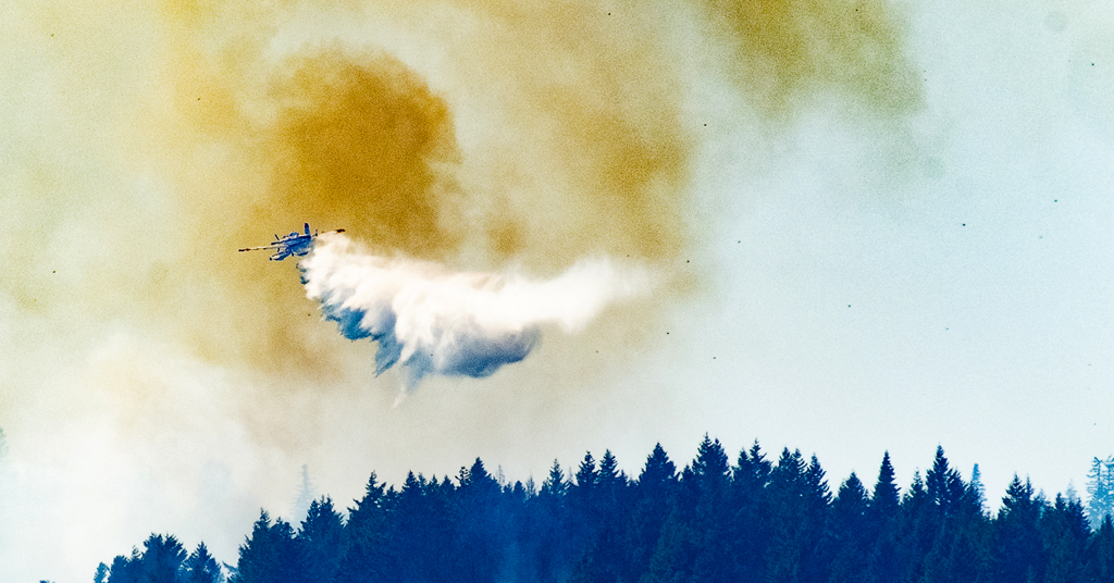
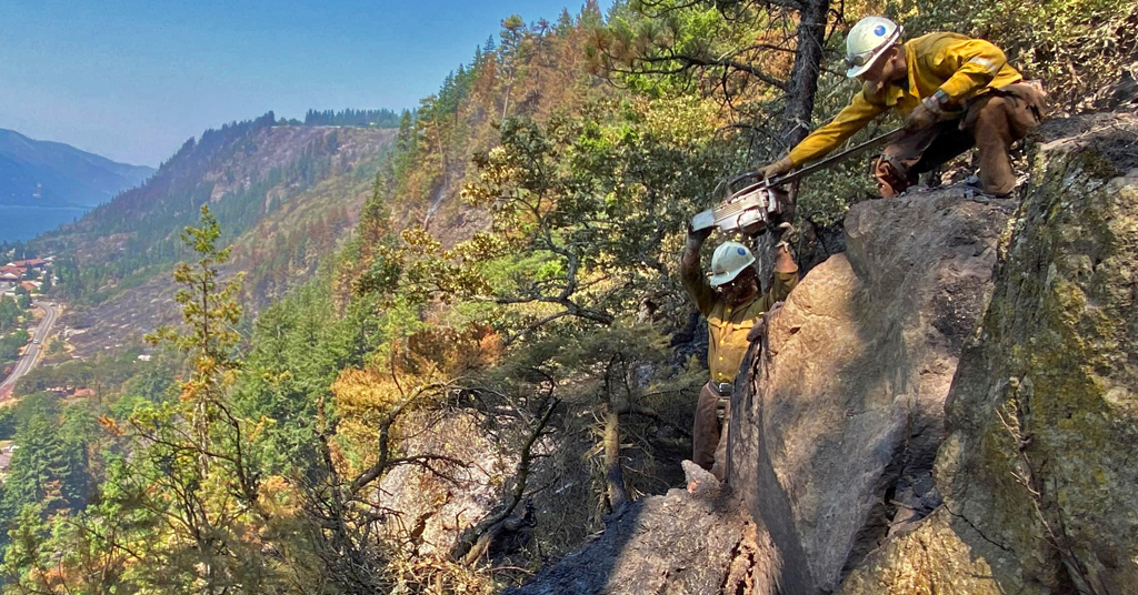
Not all can be saved: A Fire Boss amphibious air tanker dumps 200 gallons of water over the Tunnel 5 Fire. The house in flames (left) and directly beneath the water drop were completely destroyed. Photo: Jurgen Hess
By Jurgen Hess. August 3, 2023. On July 2, the Tunnel 5 Fire began in Underwood, Washington, about two miles west of the town of White Salmon in the Columbia River Gorge National Scenic Area.
Before being 80% contained by mid-July, the fire scorched 529 acres and destroyed 10 structures, mostly homes. At least 40 fire engines, 256 firefighters and other personnel, five helicopters, six dozers and 16 water tenders were employed to fight the blaze.
The cost is still being calculated, but a single retardant drop by jet airplane on the Tunnel 5 Fire cost as much as $12,400.
The expense for fighting the 2017 Eagle Creek Fire on the Oregon side of the Columbia River Gorge eventually reached $40 million.
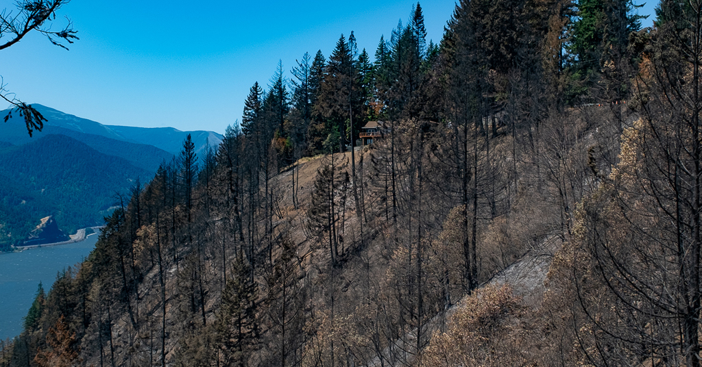
For two weeks, the Tunnel 5 Fire provided a shocking and unsettling sight as flames and smoke billowed above a stretch of the Columbia River dotted with large, cliff-top homes.
But it was hardly unprecedented.
In 2007, the Broughton Fire burned 200 acres and seven structures (including five houses) in the precise location.
That fire was caused by the BNSF Railway Company’s grinding of nearby railroad tracks. “Track grinding” or “rail grinding” repairs deformities and corrosion of rail tracks due to heavy use. The process creates sparks.
The cause of the Tunnel 5 Fire remains under investigation.
Close call: The Tunnel 5 Fire blew up steep slopes carried by fuels of trees, shrubs and grass. This house was fortunate to be spared from the fire. Photo: Jurgen Hess
Two wildfires in the exact location in just 16 years—is this simply a coincidence, a supreme stroke of bad luck?
Unfortunately no.
The Broughton and Tunnel 5 Fires burned, proved so difficult to fight and were wildly expensive to contain for similar reasons.
Might another catastrophic blaze burn in the same area in the near future?
Unfortunately it’s likely.
The reasons have to do with the geography of the area around Underwood and particular regulations that govern private property in the National Scenic Area.
But they also point to broader issues involving the encroachment of residential homes in heavily forested areas, and the way the U.S. Forest Service currently prioritizes private real estate (i.e., houses) over public resources (i.e., trees and surrounding habitat) when fighting fires.
Is such a policy wise? Is it in the public’s interest?
With national insurance companies beginning to refuse to issue policies for homes in some parts of the country due to “growing catastrophic exposure,” is it time to reconsider the construction of houses in fire-prone areas and the way we fight nearby fires when they inevitably come?
Recipe for disaster
Located along Washington State Route 14 at the confluence of the White Salmon and Columbia Rivers, Underwood is an unincorporated community within the Columbia River Gorge National Scenic Area. Its position atop a set of bluffs commands fantastic views of the Columbia River Gorge and, across the river into Oregon, Mount Hood.
But the bluffs atop which the community sits are so steep they form a nearly vertical wall.
In summer, these slopes are covered with highly flammable dry grass, brush and trees. One source of ignition and a decent wind are all that’s needed to send fires roaring up the hillside. (In the first days of the Tunnel 5 Fire, winds gusted between 35 and 40 mph.)
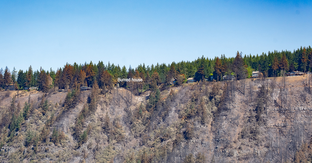
Heaven meet Hell: Slopes below Cook Underwood Road burned right up to the hilltop houses. Photo: Jurgen Hess
At the bottom of the bluffs, SR-14 and adjacent railroad tracks—both proven and potent sources of ignition—parallel the river.
At the top of the bluffs, Cook Underwood Road is lined with over 50 houses, each surrounded by forest, trees and brush.
The recipe for disaster is obvious.
“We can’t stop the fires, [we] shouldn’t build there,” Robin Dobson, a retired U.S. Forest Service ecologist who worked in the Columbia River Gorge National Scenic Area for 24 years, told Columbia Insight after the Tunnel 5 Fire. “We need to use our common sense.”
“Nobody thinks [fire] can happen to them, but the reality is that it does,” said Dan Harkenrider, USFS National Scenic Area manager from 2001 to 2011.
How Firewise are we?
In 2002, recognizing the growing problem of wildfires in rural residential areas (especially California), the National Fire Protection Agency created an educational program called Firewise Communities USA. The idea was to teach homeowners best practices for how to live “fire wise” in Wildland Urban Interface (WUI) areas as a way to mitigate potential wildfire losses.
Firewise measures include removing shrubbery and trees close to home ignition points by creating a “lean, clean and green landscape” zone; using fire-resistant building materials; screening house vents; and keeping gutters free of burnable material.
Dan Richardson, Underwood Conservation District, Climate and Community Resilience lead, administers the Firewise program in Underwood by doing a wildfire home hazard assessment.
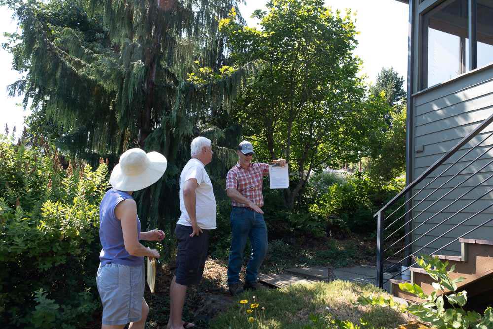
Passing grade: Dan Richardson (right) conducts a Firewise review at the Columbia River Gorge home of Luci Walker and Kevin Widener. Photo: Jurgen Hess
On a recent visit to the home of Luci Walker and Kevin Widener (north of Cook Underwood Road, not in the immediate area of burned houses), Richardson walked around the perimeter of the home looking for vegetation too close the house.
After explaining that most house fires are started by glowing embers, he noted that all vents in the house were well screened and that the house siding was made of unburnable cement board. The gutters were largely empty of burnable debris. There was no bark dust, which is very flammable.
A small juniper plant was recommended for removal.
A question arose of what to do about a long line of large Douglas fir trees on the east property line. Those trees could carry a crown fire.
Richardson concluded that picking up limbs and debris, cutting branches to a height of 10 feet and thinning out smaller trees would help reduce fire risk.
Overall, the homeowners got a report that the house met Firewise standards, with a few recommendations for improvement.
Conflicting guidelines
The Columbia River Gorge National Scenic Area Management Plan includes provisions for implementing Firewise practices.
“The reviewing agency shall provide information on Firewise standards to landowners at the time of application (for a building permit),” states the plan. “Landowners shall be encouraged to incorporate Firewise standards in their proposal.”
Fire-risk directions are also included in the Gorge Commission’s recently adopted Climate Change Action Plan.
But Lisa Naas Cook, a planner with the Gorge Commission, says meeting National Scenic Area standards of scenic preservation and reducing fire risk is a tricky dance.
That’s because homeowners in the Gorge are bound by National Scenic Area Management Plan regulations that require houses be screened with trees or other vegetation to meet scenic-protection measures.
Air war: Black spots in the sky during the Tunnel 5 Fire are hot embers driven by upslope winds. During wildland fires, embers are the primary ignition source for house fires. Photo: Jurgen Hess
In a way it feels like a trap, with Firewise and National Scenic Area guidelines appearing to be at odds.
“Absolutely there is a conflict between fire safety (and scenic standards),” said ecologist Dobson.
Cook said the Commission plans to take a closer look at the issue during its next Management Plan review.
According to the Gorge Commission’s website, the Commission can amend its plan “if it finds that conditions in the National Scenic Area have significantly changed.”
At this time, however, there is no proposal on record to amend the plan.
During the public input phase of the Climate Change Action Plan development, several members of the public argued for more stringent standards to reduce fire risk.
Janet Wainwright, a former Gorge commissioner, wrote: “Mandate (not suggest) all new construction adhere to Firewise standards. Make this one of the requirements of application approval.”
But such measures can do only so much to prevent wildfires from burning homes built within forests and other wilderness areas.
“Homeowners who live in forested settings must take responsibility and prepare their property to survive wildfire rather than relying on firefighters to save their homes,” said Jack Cohen, a USFS research scientist. “Because during intense fire conditions firefighters will likely be overwhelmed.”
Private property vs. public treasure
When fighting fires, USFS policy dictates that saving human lives is the top priority, followed by saving property, such as houses and businesses.
This became a problem when the Tunnel 5 Fire struck. Firefighters weren’t sent onto the steep slopes below the Underwood houses due to safety risks.
“It’s just too hazardous for firefighters to work on the steep ground,” Bobby Shindelar of Northwest Incident Management Team 12 told Columbia Gorge News.
Instead, at a great financial cost, aircraft dropped water and retardant on the steep slopes.
Extreme slopes: It’s not just flames and smoke that imperil firefighters. Treacherous inclines, like those faced by these Tunnel 5 firefighters, introduce another level of danger. Photo: Wash. DNR
Firewise is good practice, but after an event like the Tunnel 5 Fire it’s reasonable to wonder how much homeowners can realistically do to prevent the loss of property constructed in such an obviously precarious place.
Shifting attitudes of insurance companies may also become a factor in the way we view fighting fires.
On May 26, State Farm Insurance announced it would no longer accept applications for home and business insurance in California due to “historic increases in construction costs outpacing inflation, rapidly growing catastrophe exposure and a challenging reinsurance market.”
Some of those increased construction costs and catastrophic exposures are related to high fire risk and requirements to make new homes fire-safe.
In conversations with Columbia Insight, County Commissioner Lennon, Scenic Area Manager Harkenrider and several Tunnel 5 firefighters said they believed insurance policies would be a “check” and on future construction in fire-hazard zones.
But David Waymie, director of the Skamania County Public Works and Planning Department, which administers building permits in the area of the Tunnel 5 Fire, said his department is unlikely to require fire-protection measures for homes being rebuilt in the wake of the fire.
But, he said, “there is a risk in living in the forest. While the view is tremendous, there is a fire danger.”
Homeowners in Skamania County have two years to start the process of replacing a burned house.
Same old, same old?
Another fire in Underwood is likely because conditions that led to the previous two fires will remain stable.
SR-14 isn’t going anywhere. Neither are the railroad tracks nor the steep, vegetated cliffs directly below the community.
“For maybe 10 years or so after a fire, fuels and risks are lower. But with hotter and dryer weather fire risk is increasing, especially on these slopes,” said Lorretta Duke, South Zone fire management officer of the Gifford Pinchot National Forest, a portion of which is located in Skamania County.
Duke also points to rail-grinding operations. “Consider timing of grinding to not do that during high fire danger times,” she said.
“There needs to be conversations with Burlington Northern as to their track-grinding procedures,” Skamania County Commissioner Tom Lennon told Columbia Insight when asked about preventing future fires in the area.
Others are more blunt in their assessment of construction and rebuilding of houses destroyed or damaged in areas of high fire risk.
“It seems crazy to build a new house in this fire-risk zone,” said Harkenrider. “Where is the line where people shouldn’t be allowed to build?”
The post Why Washington’s Tunnel 5 Fire is destined to be repeated first appeared on Columbia Insight.
The post Why Washington’s Tunnel 5 Fire is destined to be repeated appeared first on Columbia Insight.
Why Washington’s Tunnel 5 Fire is destined to be repeated was first posted on August 3, 2023 at 9:19 am.
©2022 Based in Hood River, Oregon, Columbia Insight’s mission is to publish original, balanced journalism about environmental issues affecting the Pacific Northwest. Columbia Insight is a fully independent, registered nonprofit organization. To support environmental journalism “donate here” to Columbia Insight.
A cold snap boosted state revenue by $175M


Improved pricing for coal and oil, and a rollercoaster of highs and lows in the natural gas market, contributed to a stronger-than-expected revenue picture for the state budget, according to a July “pacing report” by the Consensus Revenue Estimating Group.
As of April, revenue to the state’s primary budget accounts — the General Fund and the Budget Reserve Account — was on track to exceed a January forecast by $176.1 million, or 11%, according to the report.
“It’s almost entirely due to the natural gas price environment” in December and January, CREG co-chair Don Richards said.
The CREG, made up of representatives from several state offices and the University of Wyoming “is responsible for formulating projections for the main sources of income to the major accounts in the State.”
Extremely frigid temperatures across the nation forced homes and businesses to crank the heat during those two months, which sent the price of natural gas soaring. The average spot price for natural gas at the Opal Hub in western Wyoming surpassed $26 per thousand cubic feet for more than a month, Richards said. Since, the average spot price at Opal has settled to more normal levels — $3.98 per thousand cubic feet this week.

“Natural gas isn’t just a story,” Richards said. “It’s the whole story, at least when it comes to the actual revenue in excess of CREG’s forecast.
“To put an even finer point on that,” Richards continued, “the excess revenue [$176.1 million] was generated in December 2022 and January 2023 from higher-than-anticipated prices, primarily on natural gas production on the western side of the state.”
However, pricing for natural gas, oil and coal is expected to soften, resulting in calls for a cautious approach to spending in the upcoming legislative budget session.
While the report “may appear favorable on the surface,” Gov. Mark Gordon said in a prepared statement, “this examination of recent revenues also shows gathering storm clouds on the horizon that could signal a change in Wyoming’s future revenues.”
In addition to softening fossil fuel markets, Wyoming’s mineral extraction industries face an onslaught of “anti-fossil fuel policies” from the Biden administration, Gordon said. Plus, he added, the state must come up with $330 million to maintain existing government services initiated under the American Rescue Plan Act, a stimulus package passed by Congress during the pandemic.
“We should appreciate that Wyoming has been conservative with the windfalls that have come our way in recent years,” Gordon said. “We must continue to be vigilant in our ongoing spending.”
Gordon will present his proposed budget to the Wyoming Legislature in November.
Energy industry performance
Although the volume of coal extraction is in line with last year, a 4.3% bump in pricing so far this year has helped contribute to an overall rosier revenue picture, according to the CREG report.

The same was true for oil. Production increased 6.5% over fiscal year 2022 and averaged $80.79 per barrel — a 1.4% year-over-year average price increase. However, forecasters expect oil prices to weaken in coming months due to larger-than-average stockpiles and uncertainties in the global market.
While cold weather and extremely volatile natural gas prices inflated monthly utility bills for ratepayers, they were lucrative for producers and for state revenue, which funds a variety of public services, including K-12 education.
Overall natural gas volumes fell slightly compared to last year. However, the market-disrupting cold spells last winter resulted in temporary price spikes that ultimately boosted the average natural gas price by 58.1%.
“The actual revenue in excess of our [January] forecast is due to something that occurred seven months ago,” Richards said. “We’re no longer in that environment. We might be [this winter]. Who knows?”
Higher than average utility prices — for natural gas and electrical generation — also bumped sales and use taxes from the utility sector by 32.7%. Wind power construction and upgrade projects also boosted sales and use taxes, according to the report.
The post A cold snap boosted state revenue by $175M appeared first on WyoFile.
Wyoming is expanding its sage grouse protections. Will it work?


Addressing several of Wyoming’s sage grouse decision makers, Rep. Albert Sommers (R-Pinedale) was blunt.
The rancher and influential state politician has grown tired of dealing with the “bobbing ball” of the Endangered Species Act, based on his experience with federal government employees who oversee the landmark, yet controversial environmental law in his dealings with grizzly bears.
“You’re never going to catch them,” Sommers said, referring to keeping up with changes made by the feds. “I hate to see you go down that same path, whether it’s wolves, grizzly bears or whatever. You just can’t catch them.”
Sommers was speaking July 21 at the Sublette County Library. He was sharing his skepticism with three state officials who are in the middle of revising Wyoming’s sage grouse protection map in the hopes of keeping the bird off the ESA list, which could boost grouse protections and curtail industry activity within much of the state’s sagebrush country.
Bob Budd, who chairs Wyoming’s Sage Grouse Implementation Team, told Sommers — the Legislature’s Speaker of the House — that he wished he was in Gillette for a meeting the other day to tell attendees about what it’s like dealing with a federally threatened species.
“What we’re trying to do is do everything we can not to get there,” Budd said, referring to a sage grouse listing. “And I share your pessimism.”

Budd contended the federal government’s sage grouse maps “black the state out,” meaning more expansive land use regulations to protect the bird.
“And I don’t want to go there,” he said.
The team’s overarching goal of its effort to revise its grouse “core areas” — the backbone of the state’s policy — is to convince the federal government that Wyoming is a responsible steward of the sagebrush-obligate species that has collapsed on its watch. To that end, the panel has proposed a series of changes — and they’re mostly expansions — to its sage grouse core area map. The effect, essentially, is that a higher percentage of occupied sage grouse habitat would be protected. Currently, some 84% to 85% of the estimated grouse in the Equality State dwell within the core areas.

“That may not be enough,” Budd told attendees in Pinedale. “That’s part of what we’re looking at today.”
Later, he made an accounting analogy out of sage grouse.
“If our assets are 90%, our liabilities are minor — they’re 10% and they’re scattered all over the place,” Budd said. “That’s a very strong balance sheet.”
Catalyst
Wyoming last revised its sage grouse core areas in 2015 and 2019. The policy requires state agencies to limit disturbance of grouse habitat while allowing for mineral and oil and gas development, livestock grazing and other human activities. It can also require developers to make up for unavoidable habitat loss.
Comparatively, the ongoing revision process has been truncated. The reason is the Bureau of Land Management, under court order, is revising sage grouse protections in its West-wide resource management plans via an environmental impact statement. Concurrently, the states are scrambling to update their protections so that they can be included in the federal government’s planning process.

“It’s not a friendly timeframe,” Randall Luthi, the governor’s chief energy advisor, said in Pinedale. “We’re doing the best we can.”
Wyoming’s deadline for comment on the map revisions, which was already extended once, lapsed on Friday.
“Previous changes have all been made with a very public process up front,” said Tom Christiansen, a retired sage grouse coordinator for the Wyoming Game and Fish Department.

This time, Christiansen told WyoFile, biologists were asked, “In a perfect world for sage grouse, what would you add?” Their recommendations were then tweaked, rolled out to the public as draft changes — and they caught some landowners off guard, he said.
“I think that’s very unfortunate, because it created a lot of controversy,” Christiansen said. “Unfortunately, I think this process has pitted some people against sage grouse. I hear some of the landowners in Northeast Wyoming’s concerns, some of which I think are legitimate.”

At the Pinedale meeting, Budd and Wyoming Game and Fish Department Deputy Director Angi Bruce walked landowners and other attendees through a series of expansions to core area proposed in the Upper Green River Basin, seven in all. She touted the on-the-ground sage grouse census data underlying the additions there, and beyond.
“In Wyoming we have a lot of really good science, we probably had the best data available on sage grouse in the world,” Bruce said. “We need to use that — and show we’re using it — in a constructive manner in order to retain control of the bird.”

While the sage grouse team’s fast-tracked revision to the state’s sage grouse map has raised some hackles, other parties stand firmly in support. Daly Edmunds, director of policy and outreach for Audubon Rockies, pointed to the proposed additions in the state’s northeast corner, where there are the lowest densities of grouse and the smallest percentage of birds protected by core areas.
“I think it’s time for the core areas to be reviewed,” Edmunds said.
A stand of support
Edmunds was around when Wyoming was first starting to craft a plan to protect sage grouse in the early 2000s. At the time on staff at the Wyoming Wildlife Federation, she thought back to former Gov. Dave Freudenthal’s very first public meeting about the state’s grouse policy.
“I remember [Freudenthal] saying in front of everybody, ‘If you thought the spotted owl issue was bad, if you thought the wolf issue was bad, you haven’t seen anything,’” she recalled. “He really energized Wyoming to be very forward thinking and pulled a lot of people together.”
Wyoming’s sage grouse safeguards have helped keep an Endangered Species Act listing at bay, Edmunds said. The state’s plans were “incredibly influential” when the U.S. Department of the Interior decided not to list the bird in 2015, she said.
The federal government’s “12-month finding” from that time backs it up. “The conservation efforts by federal, state, and private partners have greatly changed the likely trajectory of the species from our 2010 projections when we determined that the species warranted listing,” the document says.
Arguably, Wyoming plays an outsized role in the fate of the sage grouse. There are more than 1,700 known breeding areas, or leks, in the state, which houses an estimated 38% of the world’s remaining grouse, according to the Wyoming Game and Fish Department.
Potentially, the state’s current map revision could again move the needle. Whatever Wyoming and other western states send forward to the BLM will help shape an “alternative” that will be included in the agency’s draft environmental impact statement, said Brad Purdy, BLM-Wyoming’s deputy state director for communications.
Purdy described Wyoming as a collaborator to the BLM’s process and he echoed what he sees as a common goal: preventing a sage grouse listing.
“I think listing would be very, very rough on western economies,” he said, “and we’ve got to get these plans right and implemented.”

The BLM’s environmental document will outline changes to 70 resource management plans guiding sage grouse conservation on 67 million acres of 10 western states. Purdy said it’s tough to put a target on when the draft will come out, but guessed this coming spring.
Meantime, the state of Wyoming will continue to fine tune its sage grouse core areas.
The current revision is a “really worthy effort,” said Brian Rutledge, a recently retired Audubon employee who was a longtime member of the Sage Grouse Implementation Team.
“It was the best conservation effort I was ever involved in,” Rutledge said of the team. “The state of Wyoming and all the members of the SGIT have worked so hard toward the largest terrestrial landscape conservation effort in the history of planet Earth. That’s a big deal.”
Sommers told WyoFile he remains skeptical.
After hearing from constituents who weren’t pleased with core area expansions that overlapped their private land, he requested the Pinedale meeting. Personally, he was happy with the effectiveness of the state’s sage grouse policy the way it was.
“By and large, we created a plan that was working,” Sommers said. “What was wrong with the plan that we had? Is the only reason we were making this jump to expand the maps because the feds have a worse map?
“I don’t know the answer to that,” he said, “but it appears to me that’s the case.”
The post Wyoming is expanding its sage grouse protections. Will it work? appeared first on WyoFile.
The flood waters disproportionately hit Vermont’s affordable housing stock — at the worst time

Krystal Marshall loves the Montpelier townhouse she’s rented for the last two years, which abuts the North Branch of the Winooski River in the back. It’s the first place that’s felt like “an actual home,” she said, in part because she and her two kids each have had a room of their own.
The townhouse is part of the North Branch Apartments, a 39-unit complex owned by the nonprofit affordable housing developer Downstreet. The complex consists of two sets of buildings lining the river — located at 87 and 89 Elm Street — separated by a small pocket park, where Marshall and her mother recently dug up the weeds and planted flowers.
“I love the space. I loved the community here,” Marshall said. “It feels like everybody that are in these two Downstreet buildings seem to really look out for one another.”
The catastrophic flooding that hit Vermont earlier this month tore up those flowers — and caused major damage to 87 Elm, displacing all of its residents. On the door of Marshall’s townhouse, fire safety inspectors have posted a “DO NOT ENTER” sign. Alongside it was a handwritten flier advertising free legal help.
A full accounting of the destruction wrought to Vermont’s housing stock is not yet available. Only top line numbers are beginning to trickle in, and they are preliminary. But a pattern appears to be emerging: Whether it’s rental buildings in north Barre City or a manufactured home park in Berlin, some of the hardest-hit housing was also Vermont’s most affordable.

From a first look at Federal Emergency Manage Agency data, Vermont Housing Commissioner Josh Hanford said reports thus far indicate that floodwaters disproportionately impacted low-income areas.
“There (are) lots of homes on back roads — single-family homes, middle-income and higher that also (were) damaged,” he said. “But not at this scale.”
There are many reasons why that might be. Vermont’s villages have historically been built in river valleys, and denser development has been concentrated there, patterns which modern zoning codes have largely reinforced. But money has also allowed the affluent to spread out on larger lots uphill, while those with less have remained in floodplains — even as the risks have grown.
“Market pressures … are constantly pushing lower income people further and further toward options that reduce their quality of life — older, more degraded housing stock, or housing stock that churns through natural disasters more quickly,” said state Sen. Kesha Ram Hinsdale, D/P-Chittenden Southeast, who chairs the Senate’s Economic Development, Housing & General Affairs Committee.
“Just the lack of available affordable housing in high, dry places, is a major factor in all of this,” Ram Hinsdale said.
Not ‘going to put it on the most expensive land’
Those development patterns are particularly striking when it comes to Vermont’s manufactured home communities. About 10% of the state’s manufactured home lots are in floodplains, according to preliminary research from the University of Vermont. And as with Tropical Storm Irene in 2011, it appears that these parks were once again hit hard.
Kelly Hamshaw, a senior lecturer in the Department of Community Development and Applied Economics at UVM, and a Ph.D. student focused on resilience and manufactured home communities, said there are a few reasons why that is. For one, these manufactured home communities largely pre-date regulations that might have prevented them from being located there. And second, the land was cheap.
“You have all of these late ’60s communities that popped up in places where, if it was going to be affordable housing, they weren’t necessarily going to put it on the most expensive land,” she said.
Even affordable housing developers, who are subsidized by public funds and private philanthropy (and aren’t trying to turn a profit), struggle to acquire property at reasonable prices. Marshall’s home at 87 Elm, for example, only came into Downstreet’s possession because of a prior flood. The nonprofit had been pursuing the North Branch apartments for years, but couldn’t get the owner to sell for a price it could afford until 1992, when a late winter flood devastated the capital’s downtown.
“We were concerned about gentrification of Montpelier — which actually was right on the money,” said Rick DeAngelis, who spearheaded the North Branch project as the then-head of the Central Vermont Community Land Trust, which later rebranded as Downstreet. The land trust was “so relieved” to finally acquire the housing, he said, that it “maybe didn’t focus enough” on future risks.
“We didn’t really think a lot about that — that we were going to be into this coming global warming crisis and it would flood every, you know, 10 years,” he said.
While Downstreet may have underestimated the risk at that time, it did not exactly ignore them. The buildings at 89 Elm — on the other side of the pocket park from Marshall — were so badly damaged from the 1992 flood that they were torn down afterward and rebuilt above the floodplain, according to DeAngelis. But because 87 Elm was merely rehabbed, flood resiliency work was more limited.
Elevating 89 Elm largely worked. Only the basement flooded, and most tenants were not displaced, although an inspection this week found that three units would need to be vacated temporarily because of high moisture levels.
But at 87 Elm, flooding tipped over an oil tank, damaged four first-floor units and affected building systems located in the basement. The entire building has been emptied, and Marshall said she’s been told it could be weeks, if not months, before she can return.

Angie Harbin, Downstreet’s executive director, noted that the vast majority of the nonprofit’s housing stock was spared. Of more than 500 units, only 26 were evacuated, displacing 52 residents.
Hanford, Vermont’s housing commissioner, said he’s actually far more worried about privately owned rental properties, which aren’t subject to the flood-resilient building standards that publicly funded affordable housing projects must follow.
He pointed, for example, to a much newer Downstreet development, the Taylor Street apartments. It sits atop of Montpelier’s new transit center, and was completely unscathed by the flood — despite being sited just a block away from where the Winooski River meets its North Branch tributary. Floodwaters completely inundated the area, but because the housing units themselves were elevated, they weren’t impacted at all.
But the vast majority of renters don’t live in developments managed by nonprofits like Downstreet, he noted. Instead, they’re in privately owned properties rented out for profit. Those landlords will now have to take out a loan from the federal government to get their units back online.
“I’m fearful that some of these will not be quickly repaired, and make addressing our housing situation even harder,” he said.

‘Where are they going to find the units?’
Vermont is in the midst of a well-documented and acute housing crisis. The state’s rental vacancy rates are among the lowest in the nation — and its rates of homelessness the highest.
Hanford said Tuesday FEMA has already verified damage to about 850 residential structures. Even if most of those buildings are repairable, he said, the people who were living there need somewhere to stay in the interim. (Separately, some 4,000 Vermonters have already reported to 211 that their residences were damaged, with 750 saying their homes are uninhabitable.)
FEMA will provide impacted residents temporary rental assistance, but the federal agency has been scouring for units and coming up empty. The agency even expanded its search to look for rentals at 150% of the fair market rents set by the U.S. Department of Housing and Urban Development — and still could only find 149 units, according to Hanford.
“So if we’ve just displaced over 800 households or more, where are they going to find the units, when we have that sort of supply?” Hanford said. “How are those vouchers going to even work?” (At a town hall on Wednesday, one official with the U.S. Department of Agriculture offered this potential solution: Accept a publicly subsidized unit — out of state.)
At a special flood recovery hearing held by state lawmakers on Thursday, Sue Minter, the executive director of the anti-poverty nonprofit Capstone Community Action, noted that 300 to 400 renters have been impacted by flooding in Barre City, where more than half of all households are renters.
“We know that (there) is going to be a significant increase of people with nowhere to go,” she said. “And it isn’t going to be a quick fix because there (is) no housing to rent short term.”

The state should advocate for short-term non-congregate housing from FEMA, she said, emphasizing that the problem would likely continue to reveal itself to be even more acute than initially estimated as more properties are inspected and deemed uninhabitable.
Emotional testimony a few hours later from Jake Hemmerick, the Granite City’s newly elected mayor, underlined the point. He emphasized that these were “fuzzy” and early projections, but as much as 10% of Barre City’s housing stock might have been impacted, he said. Even worse: The people who were flooded will have the hardest time bouncing back.
“My sense is the neighborhoods that were the hardest hit were the least resourced,” he said.
At Downstreet, Harbin said the plan is to get every single unit back online — including the ones that flooded. The nonprofit will look for ways to mitigate future damage, she said, but it “simply cannot lose the housing stock.”
Marshall, at 87 Elm, said she plans to move back in. She acknowledged feeling nervous about it, but said she sees no other options.
“If I left here, I would be at the B.O.R. with everybody else,” she said, referring to Barre City’s municipal auditorium, where the Red Cross has staged an emergency shelter to serve area residents impacted by the flood.

Marshall is temporarily staying in a smaller apartment also owned by Downstreet, which happened to be vacant. She noted that, relative to many of her former neighbors who have also been displaced, she’s one of the lucky ones. Some are renting Airbnbs, couch surfing or staying in shelters. (One household has found a permanent alternative, according to Harbin.)
Indeed, DeAngelis, who is now co-director of the Central Vermont shelter network Good Samaritan Haven, told VTDigger that last week he ran into a woman he recognized at the Red Cross shelter. She had once stayed at Good Sam’s Berlin shelter, and after months of searching, finally found an apartment — at 87 Elm.
“What are you doing here?” DeAngelis recalled asking her. “And she said, ‘I got flooded out.’”
She is now back where she started: a room at Good Sam.
Read the story on VTDigger here: The flood waters disproportionately hit Vermont’s affordable housing stock — at the worst time.
What Thursday’s Supreme Court order means for the future of the Mountain Valley Pipeline — and for West Virginia

Lawyers were nearly half-way through their arguments in a federal courthouse Thursday in Richmond, Va. when one of the presiding judges informed the court that the Supreme Court had issued an order allowing construction to resume on the Mountain Valley Pipeline.
The brief, unsigned order added another layer of complexity to the already-complicated case, leaving the future of a $6.6 billion controversial natural gas pipeline, endangered species and a national forest hanging in the balance.
Here’s where things stand.
How the Supreme Court got involved
The 4th Circuit issued two stays — temporary holds — on the project earlier this month after environmental groups filed motions requesting the pipeline’s construction to stop. The groups argued that, without a stay, the pipeline’s construction would cause “irreparable harm” while the current legal challenges worked their way through the courts.
Lawyers for the pipeline responded by filing an emergency petition with the Supreme Court to get the holds removed and the two pending cases dismissed, citing the need for quick action in order to meet the project’s winter deadline.
They got some of what they wanted: the high court, in an unsigned order Thursday, threw out the stays, which means construction can resume on the last section needed to finish the 303-mile natural gas pipeline: a controversial 3.5-mile section that snakes through the fragile terrain of the Jefferson National Forest. But the Supreme Court didn’t weigh in on the pending cases, leaving the 4th Circuit to decide whether to move forward with the lawsuits.
The role of the 4th Circuit Court
The Supreme Court’s decision came down right as pipeline lawyers, environmental lawyers and judges were all gathered in the federal courthouse in Richmond, Va., to hear arguments on a motion to dismiss the current legal challenges against the pipeline.
Those lawsuits, all filed by environmental groups, argue the pipeline’s plan doesn’t follow federal environmental law. One challenge stems from the U.S. Forest Service’s move in May to amend its land management plan: as proposed, the project violated several standards of the national forest’s original plan. Attorneys for the Wilderness Society petitioned the 4th Circuit Court to review the amended Land and Resource Management Plan, arguing that it violates several environmental laws, including the National Environmental Policy Act and the National Forest Management Act.
The lawsuit also argued that the permit granted to the pipeline by the Bureau of Land Management violated the National Environmental Policy Act.
The other pending lawsuit, filed by a coalition of environmental groups, including the Sierra Club and Appalachian Voices, challenged the U.S. Fish and Wildlife Service’s 2023 report that concluded endangered species wouldn’t be jeopardized by the pipeline.
Thursday’s arguments revolved around a motion to dismiss the environmental groups’ cases. Backers of the pipeline argue that the 4th Circuit Court no longer has jurisdiction over the legal challenges, after Congress passed a debt ceiling bill that included a provision to fast track the remaining approvals needed to complete the pipeline and stripped the court’s power to review permits given to the project by federal departments.
The provision also gave the D.C. Circuit Court of Appeals sole judiciary authority over any legal challenges against the pipeline.
While the pipeline says the 4th Circuit Court no longer has authority, the environmental groups disagree. As the news of the Supreme Court decision allowing pipeline construction to resume came down on Thursday, it was right as Kym Meyer of the Southern Environmental Law Center was arguing that Congress didn’t have the constitutional authority to reassign authority over the pipeline.
“You can’t use jurisdiction stripping, as Congress has intended to here, as a means to an end,” she said. Instead, the groups are arguing that Congress overstepped and violated the separation of powers doctrine, which is meant to prevent a governmental branch from having too much authority.
Now, the court has to determine whether Congress overstepped its constitutional authority and if it even has jurisdiction to rule on the constitutionality of the pipeline provision enacted by Congress.
The fate of the Mountain Valley Pipeline
Ultimately, the future of the pipeline is still uncertain. Its completion can’t be guaranteed as it still waits for the 4th Circuit Court to decide whether to dismiss the pending two cases challenging the project.
If the court decides to dismiss the cases, the environmental groups could potentially pursue legal recourse through the D.C. Circuit Court, which was the court Congress granted jurisdiction through the debt ceiling bill. But if the court decides not to dismiss the lawsuits, the environmental groups could try to halt construction again as their cases continue to work through the court.
For now, what comes next will be determined by how the 4th Circuit Court rules over the motion to dismiss the cases. Until then, construction on the pipeline can continue.
What Thursday’s Supreme Court order means for the future of the Mountain Valley Pipeline — and for West Virginia appeared first on Mountain State Spotlight, West Virginia’s civic newsroom.
EPA posts databases of pesticide harm to people, pets and wildlife for first time in agency history

The U.S. Environmental Protection Agency posted searchable databases of pesticide harm for the first time in agency history on Thursday.
The databases, which include reports of harm to people, pets, wildlife and the environment, include information from pesticide companies, state regulators, direct complaints to the EPA and reports to the National Pesticide Information Center and the American Association of Poison Control Centers.
The EPA regulates pesticides through the Federal Insecticide, Fungicide and Rodenticide Act. After a pesticide is registered, manufacturers are required to report incidents of harm to the agency. The EPA is supposed to use that information in its safety assessments, though previous Investigate Midwest reporting shows the agency had no system for reviewing incidents.
“People have the right to know when accidental pesticide exposures or other incidents are reported to the agency,” said Michal Freedhoff, EPA assistant administrator for the Office of Chemical Safety and Pollution Prevention, in a press release. “It is particularly critical to share how pesticides may have impacted our most vulnerable populations, including children and farmworkers.”

The EPA said that it is releasing the information in alignment with its Equity Action Plan and President Joe Biden’s Executive Order 14096, Revitalizing Our Nation’s Commitment to Environmental Justice for All.
“This is the most significant step the EPA has taken in years to increase transparency about pesticides’ harms,” said Nathan Donley, environmental health science director at the Center for Biological Diversity, a nonprofit working to protect endangered species. “Making this database publicly available will help the public hold regulators accountable for overseeing and reducing pesticides’ harms and, when necessary, revoking their use.”
The EPA is releasing only the 10 most recent years of data. The agency said in a press release that they only previously released this information via Freedom of Information Act requests and in registration reviews.
Investigate Midwest obtained the databases in 2021 and has used them in reporting on incident reports of harm to pets and people from pesticide products. At the time, the EPA’s Freedom of Information Act officers said they had never released the databases before.
This includes stories about the popular Seresto flea and tick collar, which has been the subject of more complaints about pet harm and deaths than any other product in EPA history. The EPA recently announced additional reporting requirements on Seresto.
The agency published two data sets: a main incident data set and an aggregate data set. The main data set involves more severe incidents and contains “a description of the incident (e.g., who was involved, how it happened, and where the incident occurred).” The aggregate database includes bulk numbers of incident data.
“EPA is publishing these data sets to increase transparency to the public, but the agency does not currently have the resources to answer individual questions about its content,” the EPA said in a press release.
The agency stressed that incident reports are not reviewed for accuracy and that the existence of an incident report does not mean that the pesticide involved caused that incident.
The post EPA posts databases of pesticide harm to people, pets and wildlife for first time in agency history appeared first on Investigate Midwest.
Will the reduction of red tape put conservation success at risk?

After years of work, the Flathead Basin Commission released a map this spring identifying the highest potential risks from septic systems in the Flathead Basin. Many populated areas near bodies of water like Flathead Lake and Lake Mary Ronan were identified as “very high-risk,” meaning there is potential for septic systems to leak into the groundwater and, eventually, the surface water.
The commission had hoped the map would be a tool for planners and policymakers. Nutrient pollution is a leading cause of water impairment in the state, according to the Montana Environmental Information Center, and nutrients often get into the water via “nonpoint sources,” such as leaking septic systems or agricultural runoff, that accumulate into larger problems.
The FBC – initially formed by the Legislature in 1983 to help keep clean the water in the Flathead Basin – devoted a lot of attention to nonpoint source pollution.
Now, as part of Montana Gov. Greg Gianforte’s Red Tape Relief initiative, the FBC is no more, combined instead with the Upper Colombia Conservation Commission, or UC3. The Western Montana Conservation Commission will replace the two groups that were dedicated to different problems in different watersheds. WMCC will extend its focus to six watersheds in western Montana.
In the Upper Columbia River Basin’s case, the former commission there accomplished its main objective, ridding the state of invasive mussels. But in the Flathead Basin, some are worried its needs are going to lose priority when combined with a larger area.
For that reason, Jim Elser was not in favor of combining the commissions.
In the Flathead Basin, the main focuses were curtailing nutrient pollution and aquatic invasive species, said Elser, the director of the Flathead Lake Biological Station.
Since Flathead Lake bolsters the state economy – homes on the lake adding $12 to $17 million in property taxes, according to a 2021 study – it’s a very “lake-focused” basin, Elser said. One reason he agreed to be on the new commission was to make sure he has an “opportunity to call attention to the Flathead and its challenges and importance.”
Flathead Lake is known for its pristine water quality. Kate Sheridan, executive director of the water quality advocacy group the Flathead Lakers, said the biggest threat to the lake, other than something like an oil spill from the railway, is contamination from septic systems. Sheridan said headway was being made on that problem, and progress is going to need to continue as people keep moving to northwest Montana.
“We just don’t want to lose focus on the Flathead because we feel that this area is incredibly valued both ecologically and economically to Montana,” Sheridan said.
Sheridan said the new commission bringing on more watersheds brings their individual needs and concerns. She brought up the Clark Fork River Basin – a designated Superfund site included in the WMCC’s purview – and how that compares to Flathead Lake, which doesn’t have such considerable issues. She said she hopes the focus on Flathead Lake won’t diminish, although she’s optimistic about the way the new commission is taking shape.
Aquatic invasive species, like zebra, quagga and dreissenid mussels, were the main focus of the former UC3. Such invasive species were anticipated to have a negative economic impact on Montana – one study estimated a loss of $230 million – if they took hold in the state’s rivers and lakes.
After the first identification of dreissenid mussels in the Tiber Reservoir in 2016 – about 50 miles east of Shelby – there has been no physical evidence of mussels in Montana since 2017, said Phil Matson, head of the water quality and invasive species program at the Flathead Lake Biological Station and former UC3 member.
Every year boats pass through inspection stations across the state with living or dead mussels attached, Matson said, but there’s been no evidence of the invasive species in water samples.
But Matson, who has been nominated by the UC3 to serve on the new WMCC, said boat inspection records show that mussels could be coming back in full force.
“The problem’s not over,” Matson said. “These boats are coming from all over the place, and those are the main threats.”
Despite the success curbing invasive species in the state, during the last meeting of the UC3, one identified downside of the commission was that it covered too big of an area and that its resources were spread too thin.
Mark Bostrom, administrator of the Conservation and Resource Development Division at the Montana Department of Natural Resources and Conservation, said the biggest hurdle now is trying to figure out how to handle an even bigger area with many issues that continue to demand attention.
“That’s the challenge, trying to do a consolidation on a bigger area and not grow government,” Bostrom said.
Bostrom, a former member of the FBC, said he’s excited about the new WMCC. Working with a former colleague on the UC3, they often asked each other, “Why do we even have these two commissions?”
Mike Koopal was one of the researchers who developed the septic risk map and is a former FBC member.
Koopal said the map overlays physical risk — things like how nutrients from septic systems can move through the soil and how far the residue from septic systems is to ground and surface water — with septic permit data from Flathead County, which included the age of each system.
What the map shows is that there are more than 30,000 septic systems in Flathead County and roughly a third of them are older than 30 years, Koopal said. The average lifespan for an appropriately functioning septic system is 25 to 30 years.
“It’s an issue that’s only going to grow in scope and size,” Koopal said. “We will have more septic on the landscape as more and more people move to Montana. And at the same time, the existing septics on the landscape are aging.”
Koopal said the new commission has a great opportunity to expand the map.
From an administrative perspective, Casey Lewis said combining the two commissions simplifies many things — projects, budgets and all the overlap in between. Lewis will be the new executive director for WMCC, a position she previously held at both the UC3 and the FBC.
Lewis is excited about the new commission and she sees a possibility to take the FBC’s mission and expand it west of the Continental Divide. She said the WMCC won’t lose track of issues in the Flathead.
“I anticipate septic systems and septic leachate to be a topic we continue to work on, and, ideally, we will expand the septic risk map to all of western Montana,” Lewis said in an email.
In-depth, independent reporting on the stories impacting your community from reporters who know your town.
The post Will the reduction of red tape put conservation success at risk? appeared first on Montana Free Press.
¿Cómo es el programa gratuito que enseña a trabajadores agrícolas a utilizar herramientas digitales?

El objetivo es aumentar la educación digital para la comunidad de trabajadores agrícolas en Carolina del Norte.
La entrada ¿Cómo es el programa gratuito que enseña a trabajadores agrícolas a utilizar herramientas digitales? se publicó primero en Enlace Latino NC.