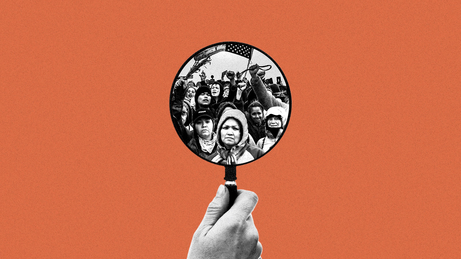
FBI sent several informants to Standing Rock protests, court documents show
Up to 10 informants managed by the FBI were embedded in anti-pipeline resistance camps near the Standing Rock Sioux Indian Reservation at the height of mass protests against the Dakota Access pipeline in 2016. The new details about federal law enforcement surveillance of an Indigenous environmental movement were released as part of a legal fight between North Dakota and the federal government over who should pay for policing the pipeline fight. Until now, the existence of only one other federal informant in the camps had been confirmed.
The FBI also regularly sent agents wearing civilian clothing into the camps, one former agent told Grist in an interview. Meanwhile, the Bureau of Indian Affairs, or BIA, operated undercover narcotics officers out of the reservation’s Prairie Knights Casino, where many pipeline opponents rented rooms, according to one of the depositions.
The operations were part of a wider surveillance strategy that included drones, social media monitoring, and radio eavesdropping by an array of state, local, and federal agencies, according to attorneys’ interviews with law enforcement. The FBI infiltration fits into a longer history in the region. In the 1970s, the FBI infiltrated the highest levels of the American Indian Movement, or AIM.
The Indigenous-led uprising against Energy Transfer Partners’ Dakota Access oil pipeline drew thousands of people seeking to protect water, the climate, and Indigenous sovereignty. For seven months, participants protested to stop construction of the pipeline and were met by militarized law enforcement, at times facing tear gas, rubber bullets, and water hoses in below-freezing weather.
After the pipeline was completed and demonstrators left, North Dakota sued the federal government for more than $38 million — the cost the state claims to have spent on police and other emergency responders, and for property and environmental damage. Central to North Dakota’s complaints are the existence of anti-pipeline camps on federal land managed by the Army Corps of Engineers. The state argues that by failing to enforce trespass laws on that land, the Army Corps allowed the camps to grow to up to 8,000 people and serve as a “safe haven” for those who participated in illegal activity during protests and caused property damage.
In an effort to prove that the federal government failed to provide sufficient support, attorneys deposed officials leading several law enforcement agencies during the protests. The depositions provide unusually detailed information about the way that federal security agencies intervene in climate and Indigenous movements.
Until the lawsuit, the existence of only one federal informant in the camps was known: Heath Harmon was working as an FBI informant when he entered into a romantic relationship with water protector Red Fawn Fallis. A judge eventually sentenced Fallis to nearly five years in prison after a gun went off when she was tackled by police during a protest. The gun belonged to Harmon.
Manape LaMere, a member of the Bdewakantowan Isanti and Ihanktowan bands, who is also Winnebago Ho-chunk and spent months in the camps, said he and others anticipated the presence of FBI agents, because of the agency’s history. Camp security kicked out several suspected infiltrators. “We were already cynical, because we’ve had our heart broke before by our own relatives,” he explained.
“The culture of paranoia and fear created around informants and infiltration is so deleterious to social movements, because these movements for Indigenous people are typically based on kinship networks and forms of relationality,” said Nick Estes, a historian and member of the Lower Brule Sioux Tribe who spent time at the Standing Rock resistance camps and has extensively researched the infiltration of the AIM movement by the FBI. Beyond his relationship with Fallis, Harmon had close familial ties with community leaders and had participated in important ceremonies. Infiltration, Estes said, “turns relatives against relatives.”
Less widely known than the FBI’s undercover operations are those of the BIA, which serves as the primary police force on Standing Rock and other reservations. During the NoDAPL movement, the BIA had “a couple” of narcotics officers operating undercover at the Prairie Knights Casino, according to the deposition of Darren Cruzan, a member of the Miami Tribe of Oklahoma who was the director of the BIA’s Office of Justice Services at the time.
It’s not unusual for the BIA to use undercover officers in its drug busts. However, the intelligence collected by the Standing Rock undercovers went beyond narcotics. “It was part of our effort to gather intel on, you know, what was happening within the boundaries of the reservation and if there were any plans to move camps or add camps or those sorts of things,” Cruzan said.
A spokesperson for Interior Secretary Deb Haaland, who oversees the BIA, also declined to comment.
According to the deposition of Jacob O’Connell, the FBI’s supervisor for the western half of North Dakota during the Standing Rock protests, the FBI was infiltrating the NoDAPL movement weeks before the protests gained international media attention and attracted thousands. By August 16, 2016, the FBI had tasked at least one “confidential human source” with gathering information. The FBI eventually had five to 10 informants in the protest camps — “probably closer to 10,” said Bob Perry, assistant special agent in charge of the FBI’s Minneapolis field office, which oversees operations in the Dakotas, in another deposition. The number of FBI informants at Standing Rock was first reported by the North Dakota Monitor.
According to Perry, FBI agents told recruits what to collect and what not to collect, saying, “We don’t want to know about constitutionally protected activity.” Perry added, “We would give them essentially a list: ‘Violence, potential violence, criminal activity.’ To some point it was health and safety as well, because, you know, we had an informant placed and in position where they could report on that.”
The deposition of U.S. Marshal Paul Ward said that the FBI also sent agents into the camps undercover. O’Connell denied the claim. “There were no undercover agents used at all, ever.” He confirmed, however, that he and other agents did visit the camps routinely. For the first couple months of the protests, O’Connell himself arrived at the camps soon after dawn most days, wearing outdoorsy clothing from REI or Dick’s Sporting Goods. “Being plainclothes, we could kind of slink around and, you know, do what we had to do,” he said. O’Connell would chat with whomever he ran into. Although he sometimes handed out his card, he didn’t always identify himself as FBI. “If people didn’t ask, I didn’t tell them,” he said.
He said two of the agents he worked with avoided confrontations with protesters, and Ward’s deposition indicates that the pair raised concerns with the U.S. marshal about the safety of entering the camps without local police knowing. Despite its efforts, the FBI uncovered no widespread criminal activity beyond personal drug use and “misdemeanor-type activity,” O’Connell said in his deposition.
The U.S. Marshals Service, as well as Ward, declined to comment, citing ongoing litigation. A spokesperson for the FBI said the press office does not comment on litigation.
Infiltration wasn’t the only activity carried out by federal law enforcement. Customs and Border Protection responded to the protests with its MQ-9 Reaper drone, a model best known for remote airstrikes in Iraq and Afghanistan, which was flying above the encampments by August 22, supplying video footage known as the “Bigpipe Feed.” The drone flew nearly 281 hours over six months, costing the agency $1.5 million. Customs and Border Protection declined a request for comment, citing the litigation.
The biggest beneficiary of federal law enforcement’s spending was Energy Transfer Partners. In fact, the company donated $15 million to North Dakota to help foot the bill for the state’s parallel efforts to quell the disruptions. During the protests, the company’s private security contractor, TigerSwan, coordinated with local law enforcement and passed along information collected by its own undercover and eavesdropping operations.
Energy Transfer Partners also sought to influence the FBI. It was the FBI, however, that initiated its relationship with the company. In his deposition, O’Connell said he showed up at Energy Transfer Partners’ office within a day or two of beginning to investigate the movement and was soon meeting and communicating with executive vice president Joey Mahmoud.
At one point, Mahmoud pointed the FBI toward Indigenous activist and actor Dallas Goldtooth, saying that “he’s the ring leader making this violent,” according to an email an attorney described.
Throughout the protests, federal law enforcement officials pushed to obtain more resources to police the anti-pipeline movement. Perry wanted drones that could zoom in on faces and license plates, and O’Connell thought the FBI should investigate crowd-sourced funding, which could have ties to North Korea, he claimed in his deposition. Both requests were denied.
O’Connell clarified that he was more concerned about China or Russia than North Korea, and it was not just state actors that worried him. “If somebody like George Soros or some of these other well-heeled activists are trying to disrupt things in my turf, I want to know what’s going on,” he explained, referring to the billionaire philanthropist, who conspiracists theorize controls progressive causes.
To the federal law enforcement officials working on the ground at Standing Rock, there was no reason they shouldn’t be able to use all the resources at the federal government’s disposal to confront this latest Indigenous uprising.
“That shit should have been crushed like immediately,” O’Connell said.
In Washington, a missing wolf mystery baffles officials
What happened to the female half of Klickitat County’s two-wolf Big Muddy Pack?
Half-pack: Wildlife biologists collared gray wolf WA109M in January 2021 in Klickitat County. Now his mate has gone missing. Photo: WDFW
By Dawn Stover.February 27, 2024. In April 2023, Columbia Insightreportedthat Southwest Washington had its first gray wolf pack in a century.
The Big Muddy Pack formed when a collared male that wandered into Klickitat County was joined by an un-collared female.
Together they met the Washington Department of Fish and Wildlife’s minimum for recognition as a pack: at least two wolves traveling together in winter.
The state wildlife agency’s wolf biologist Gabe Spence told Columbia Insight it was a “big deal” to finally find a pack in the southwestern third of the state.
It seemed likely the pair would produce pups in 2023.
Now wolf experts with the agency aren’t sure the pack still exists.
And some locals are wondering if the wolf may have been intentionally killed.
Missing in action
Since October 2023, the wildlife department’s monthly updates have repeatedly noted that agency experts “conducted monitoring activities” in the Big Muddy Pack’s territory. Those activities have thus far failed to detect the female member of the pack.
The collar on wolf WA109M, the pack’s male, usually transmits his location twice a day. When he’s in rocky or heavily wooded terrain, it can take longer to receive that data.
The state’s wolf team uses the collared wolf’s last known location to look for tracks in snow and check game cameras in the area.
They can also circle over the location with an airplane or helicopter.
The team’s aircraft were grounded by freezing fog and freezing rain for a few days, and team members are still finishing their surveys of all packs in the state.
Data from survey counts, camera footage and reported sightings will be compiled into an annual wolf report that will be released in mid-April, said WDFW statewide wolf specialist Ben Maletzke.
When Columbia Insight spoke with Maletzke on Feb. 14, the team had one more flight to do and some cameras to check, but they hadn’t yet been able to pick up the Big Muddy female wolf.
“We have not been super successful at finding that wolf, but that doesn’t mean she’s not out there,” Maletzke said. It’s possible she is on a hunting foray, he said, or “she may be more camera-shy” than her collared mate.
Maletzke acknowledged there is a “lot of animosity toward wolves in certain areas,” but he said there is no evidence of foul play involving the Big Muddy female.
Staci Lehman, a spokesman for the department, said “the wolf world can be a rough one. It’s not unusual for a wolf to go on a temporary or permanent road trip to new territories or to run into trouble along the way.”
New model for species recovery
If Southwest Washington’s only known pack has split up or the female has died, that would be “a big loss for sure,” said Maletzke.
In the short term, the loss of one wolf may have an impact for the next year or so, he said, “but over the next two to five years, I think we’ll see an influx of wolves down into the South Cascades.”
Maletzke said the state documented a lot of wolf mortalities in 2023 but is still seeing the species recovering in Washington.
The statewide population of wolves and the number of breeding pairs has been increasing for 14 years.
In its Periodic Status Review for the Gray Wolf dated February 2024, the Washington Department of Fish and Wildlife recommends that the state reclassify wolves from “endangered” to “sensitive,” bypassing the intermediate designation of “threatened.”
The agency says wolves no longer face a serious risk of extinction throughout a significant portion of their range in Washington.
The Wolf Management and Recovery Plan adopted in 2011 calls for the state to consider downlisting wolves from endangered to threatened when there are at least two successful breeding pairs in each of the three recovery regions for three consecutive years.
But that hasn’t happened yet.
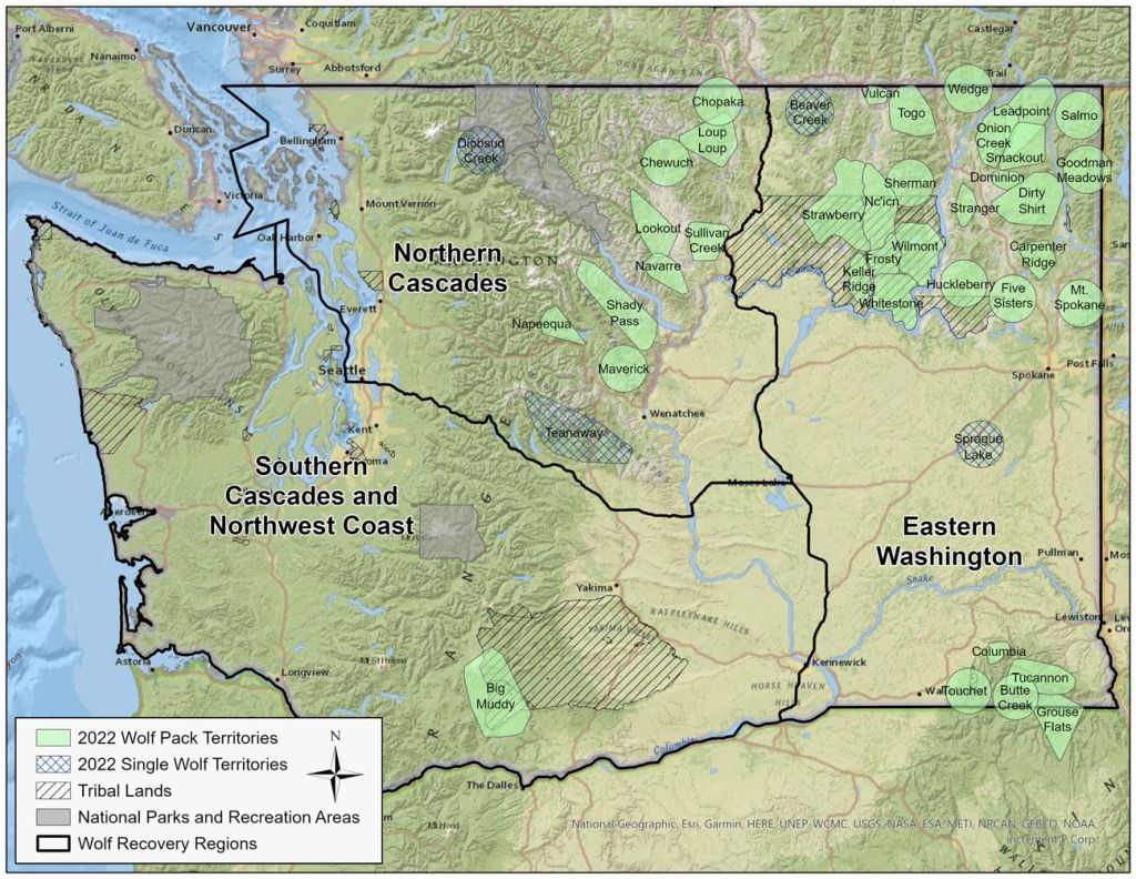
Known wolf packs and single wolf territories in Washington at the end of 2022. Map: WDFW
The Southern Cascades and Northwest Coast recovery region currently has no successful breeding pairs and, with the absence of wolf WA109M’s partner, might have lost its only known pair.
However, the state is proposing to jettison those recovery criteria and rely instead on a new model that estimates current and future population dynamics of Washington wolves.
The model estimates a 100% probability that wolves will “colonize” the southwest recovery region by 2030—meaning at least one wolf territory with two or more adults in it.
The downlisting proposal will be presented to the state’s Fish and Wildlife Commission at a meeting next month, and a decision is expected in June.
Both the draft proposal and the final version published this month note that “the first known pack was documented in [the southwest] region as of 2022.”
With limited resources, an Oregon town plans for climate change
This story was produced through a collaboration between the Daily Yonder, which covers rural America, and Nexus Media News, an editorially independent, nonprofit news service covering climate change.
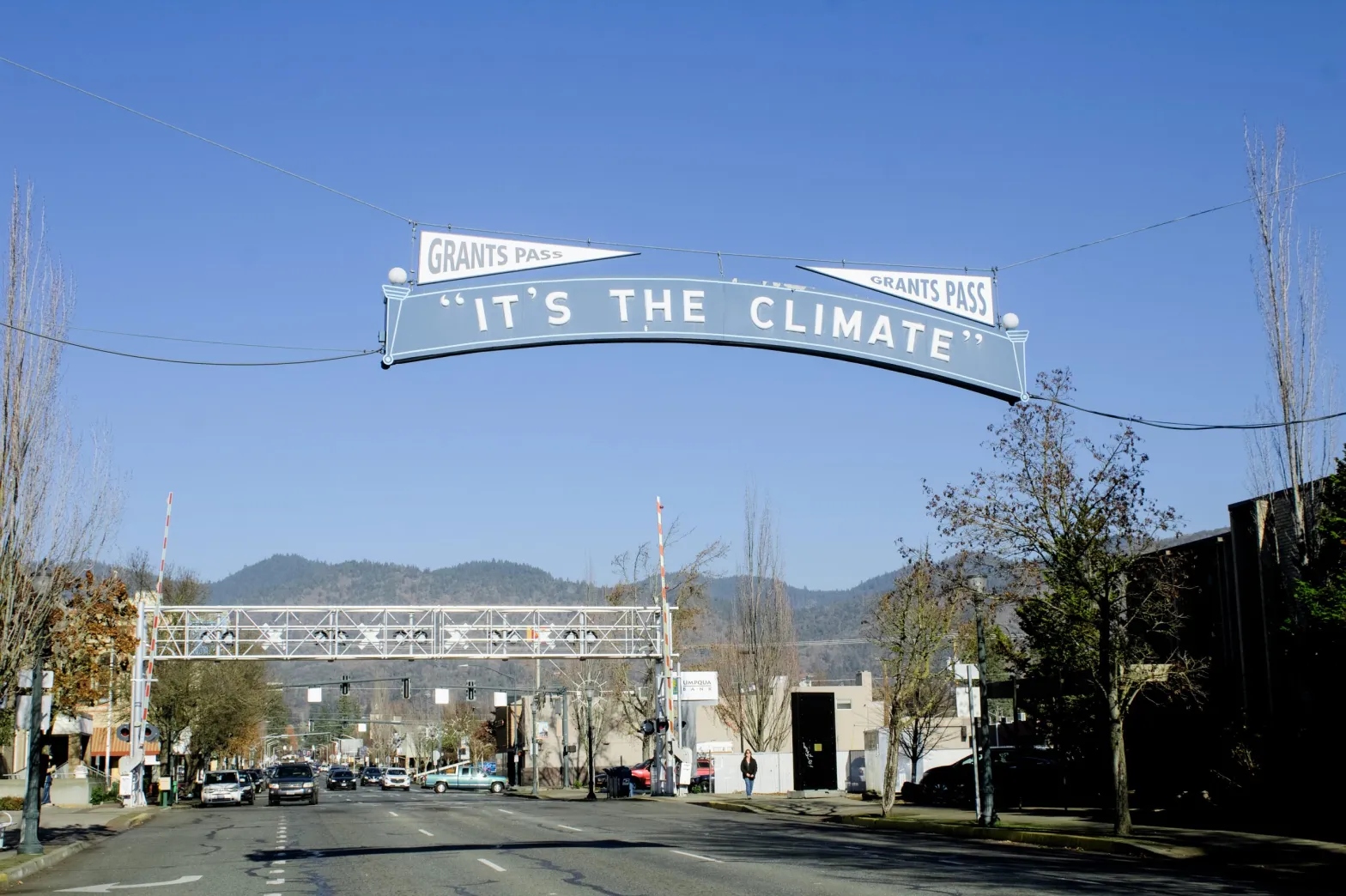
One of the most iconic landmarks in downtown Grants Pass, Oregon, is a 100-year-old sign that arcs over the main street with the phrase “It’s the Climate” scrawled across it.
To an outsider, it’s an odd slogan in this rural region, where comments about the climate – or rather, climate change – can be met with apprehension. But for locals, it’s a nod to an era when the “climate” only referred to Grants Pass’ warm, dry summers and mild winters when snow coats the surrounding mountains but rarely touches down in the city streets.
Now, the slogan takes on a different meaning.
In May 2023, the Grants Pass City Council passed a one-of-a-kind sustainability plan that, if implemented, would transition publicly owned buildings and vehicles to renewable energy, diversifying their power sources in case of natural disaster.
While passing the sustainability plan in this largely Republican county was an enormous feat on its own, actually paying for the energy projects proves to be Grants Pass’ biggest challenge yet.
The exterior of City Hall in Grants Pass on November 28, 2023.
Claire Carlson / The Daily Yonder
“There are grants out there, but I don’t think we’re the only community out there looking for grants to help pay for some of these things,” said J.C. Rowley, finance director for the city of Grants Pass. Some project examples outlined in their sustainability plan include installing electric vehicle charging stations downtown and solar panels at two city-owned landfills, and converting park streetlights to LED.
Rural communities face bigger hurdles when accessing grant funding because they don’t have the staff or budget that cities often do to produce competitive grant applications. This can slow down the implementation of projects like the ones laid out in the Grants Pass sustainability plan.
And time is not something Grants Pass — or any other community — has to spare.
Global climate models show the planet’s average annual temperature increasing by about 6.3° Fahrenheit by 2100 if “business-as-usual” practices continue. These practices mean no substantive climate change mitigation policy, continued population growth, and unabated greenhouse gas emissions throughout the 21st century — practices driven by the most resource-consumptive countries, namely, the United States.
In southwest Oregon, this temperature increase means hotter summers and less snow in the winters, affecting the region’s water resources, according to a U.S. Forest Service analysis. This could mean longer and more severe wildfire seasons.
The “It’s the Climate” sign was first hung on July 20, 1920, to promote the temperate weather of Grants Pass.
Claire Carlson / The Daily Yonder
In Roseburg, Oregon, about 70 miles north of Grants Pass, a 6.3°F increase would mean the city’s yearly average of 36 days of below-freezing temperatures would decrease to few or none, according to the analysis. Grants Pass would suffer a similar fate, drastically changing the climate it’s so famous for.
Grants Pass has a population of 39,000 and is the hub of one of the smallest metropolitan statistical areas in the U.S. The metro contains just one county, Josephine, which has a population of under 90,000, nearly half of whom live outside urbanized areas. Over half of the county’s land is owned by the Bureau of Land Management or National Forest, and it contains a section of the federal Rogue River Scenic Waterway.
“In the event of a natural disaster, we are far more likely to get isolated,” said Allegra Starr, an Americorps employee who was the driving force behind the Grants Pass sustainability plan. “I’ve heard stories of communities that were less isolated than us running out of fuel [during power outages].”
Building resilience in the face of disaster is a main priority of the plan, which recommends 14 projects related to green energy, waste disposal, transportation, and tree plantings in city limits. All of the projects focus on improvements to city-owned buildings, vehicles, and operations.
In partnership with Starr and the Grants Pass public works department, a volunteer task force of community members spent one year researching and writing the sustainability plan. In spring 2023, it was approved by the Grants Pass City Council.
Now, the public works department is in the grants-seeking stage, and they stand to benefit from the influx of climate cash currently coming from the federal government.
Money for sustainability, if you can get it
In 2022, the Biden administration passed the single largest bill on clean energy and climate action in U.S. history: the Inflation Reduction Act, which funnels $145 billion to renewable energy and climate action programs. The Bipartisan Infrastructure Law, passed in 2021, allocates $57.9 billion to clean energy and power projects.
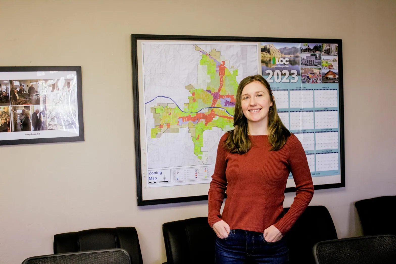
“It’s almost like drinking through a fire hose with the grant opportunities, which is a curse and a blessing,” said Vanessa Ogier, Grants Pass city council member. Ogier joined the council in 2021 with environmental and social issues as her top priority and was one of the sustainability plan’s biggest proponents.
Grants Pass city council member Vanessa Ogier at City Hall on November 28, 2023.
Claire Carlson / The Daily Yonder
But competing against larger communities for the grants funded through these federal laws is a struggle for smaller communities like Grants Pass.
“I really don’t want to look a gift horse in the mouth, but when a small community only has one grant writer and they have to focus on water systems, fire, dispatch, fleet services, and they’re torn in all these different ways, it can be difficult to wrangle and organize all these opportunities and filter if they’re applicable, if we would even qualify,” Ogier said.
Having a designated grant-writing team, which is common in larger cities, would be a huge help in Grants Pass, Ogier said.
A 2023 study by Headwaters Economics found that lower-capacity communities – ones with fewer staff and limited funding – were unable to compete against higher-capacity, typically urban communities with resources devoted to writing competitive grant applications.
“[There are] rural communities that don’t have community development, that don’t have economic development, that don’t have grant writers, that may only have one or two paid staff,” said Karen Chase, senior manager for community strategy at Energy Trust, an Oregon-based nonprofit that helps people transition their homes and businesses to renewable energy. Chase was a member of the volunteer task force that put together the Grants Pass sustainability plan.
When the Inflation Reduction Act money started rolling in, many of the rural communities Chase works with did not have plans that laid out “shovel-ready” energy and climate resiliency projects, which is a requirement of much of the funding. Grants Pass’ sustainability plan should give them a leg-up when applying for grants that require shovel-ready projects, according to Chase.
“Most of my rural communities pretty much lost out,” she said.
This is despite the approximately $87 billion of Inflation Reduction Act money classified as rural-relevant, rural-stipulated, or rural-exclusive funding, according to an analysis from the Brookings Institute. Rural outreach is part of the Biden administration’s larger goal to put money into rural communities that historically have been left out by state and federal investments.
But this outreach isn’t perfect. Most of the federal grants available to rural communities still have match requirements, which are a set amount of money awardees must contribute to a grant-funded project.
The Brookings Institute analysis, which also looked at rural funding from the Infrastructure Investment and Jobs Act and the CHIPS and Science Act, found that “over half [of the rural-significant grants programs] require or show a preference for matching funds, and less than one-third offer flexibility or a waiver.”
Of the rural-exclusive and rural-stipulated programs, less than one-third of the total grants offer match waivers or flexibility to reduce the match requirement. This makes getting those grants a lot harder for rural communities with smaller budgets.
Help from the outside
To address limited staffing, in 2021 the Grants Pass public works department applied to be a host site for an Americorps program run out of the University of Oregon.
The program, coined the Resource Assistance for Rural Environments (RARE) program, assigns graduate students to rural Oregon communities for 11 months to work on economic development, sustainability planning, and food systems initiatives. An Americorps member was assigned to Grants Pass to work as a sustainability planner from September 2022 to August 2023.
Kyrrha Sevco, business operations supervisor for the Grants Pass public works department, at City Hall on November 28, 2023.
Claire Carlson / The Daily Yonder
Without the Americorps member, Grants Pass officials say there’s no way the plan would have been written.
“She came in and learned about the city and the operations and the technical aspects of it and was able to really understand it and talk about that,” said Kyrrha Sevco, business operations supervisor for the public works department. “That’s hard to do.”
Bringing outsiders in can be a tricky undertaking in a rural community, but RARE program director Titus Tomlinson said they collaborate with the host sites to make the transition for their members as smooth as possible.
“When we place a member, we place them with a trusted entity in a rural community,” Tomlinson said. “[The site supervisor] helps them meet and engage with other leaders in the community so that they’ve got some ground to stand on right out of the gate.”
Each participating community must provide a $25,000 cash match that goes toward the approximately $50,000 needed to pay, train, and mentor the Americorps member, according to the RARE website. Communities struggling to meet this cash match are eligible for financial assistance.
Grants Pass paid $18,500 for their portion of the RARE Americorps grant.
Director of public works Jason Canady at City Hall on November 28, 2023.
Claire Carlson / The Daily Yonder
Allegra Starr, the Americorps employee, no longer works in Grants Pass since completing her 11-month term. In her stead, a committee of seven has been created to monitor and report to the city council on the progress of the plan’s implementation.
Much of this implementation work will fall on the director of the public works department, Jason Canady, and the business operations supervisor, Kyrrha Sevco.
“There has to be that departmental person who’s really carrying that lift and that load,” said Rowley, the Grants Pass finance director. “It’s the Kyrrhas and Jasons of the world who are leading the charge for their own department like public works.”
Now, Canady and Sevco are laying the groundwork for multiple solar projects. Eventually, they hope to bring to life what local high school student, and member of the original volunteer sustainability task force, Kayle Palmore, dreamed of in an essay titled “A Day in 2045,” which envisions bike lanes, wide sidewalks, solar panels, and electric vehicle charging stations on every street corner.
“A smile spreads across your face as you think of how much you love this beautiful city,” Palmore writes.
Top 5 takeaways of our investigation into state trust lands
As America grew westward in the 19th and 20th centuries, the federal government took land from Indigenous peoples and gave it to states for the creation of public colleges known as land-grant universities. A new Grist investigation reveals how many of these institutions continue to profit from this stolen land, largely through extractive industries including oil and gas production, mining, and logging.
Using publicly available data, our investigation locates millions of acres taken from more than a hundred Indigenous nations to provide ongoing sources of revenue for educational institutions. Our reporting reveals how Indigenous lands and resources bankroll land-grant universities, historically and today, and provides insight into the relationship between colonialism, higher education, and climate change.
Here are five takeaways from our investigation:
1 Fourteen land-grant universities generate revenue from 8.2 million surface and subsurface acres of Indigenous land.
State trust lands just might be one of the best kept public secrets in America: They exist in 21 Western and Midwestern states, totaling more than 500 million surface and subsurface acres. They are held and managed by state agencies and primarily exist to subsidize education. Using data from these state agencies, Grist located trust lands associated with specific land-grant institutions to determine where they are located and how they are used to benefit those colleges. “A perpetual, multigenerational land trust for the support of the beneficiaries and future generations” is how the Arizona State Land Department describes them.
2 Those 8.2 million acres were taken from at least 123 Indigenous nations through more than 150 land cessions, a legal term for the surrendering of territory.
Grist was able to compare state trust land data with federal data known as the Schedule of Indian Land Cessions, which documents Indigenous land cessions in the continental United States using extensive information on treaties and other land seizures. By joining these different datasets, we were able to get a glimpse of just how many Indigenous nations were impacted by the creation of these institutions.
3 Indigenous nations were paid approximately $4.3 million in 2023 dollars for these lands. In many cases, however, nothing was paid at all.
Based on accounting of historical payments to Indigenous nations by the Indian Claims Commission and the Court of Claims, Grist was able to identify the price paid per acre for each land cession and calculate the total amount paid to tribes for trust lands that benefit universities today. It’s important to note that in many cases, Indigenous nations were never compensated for the taking of their territory, and as our reporting reveals, those lands have continued to provide steady revenue streams to land-grant institutions. “Universities continue to benefit from colonization,” said Sharon Stein, an assistant professor of higher education at the University of British Columbia. “It’s not just a historical fact; the actual income of the institution is subsidized by this ongoing dispossession.”
4 Nearly 25 percent of land-grant university trust lands are designated for either fossil fuel production or the mining of minerals like coal and iron-rich taconite.
Utilizing datasets from state land agencies, we were able to determine what activities generated revenue for land-grant universities. While much of our focus is on the energy industry due to its massive climate impact, we found that grazing is permitted on about a third of the land, or approximately 2.8 million surface acres. Timber, agriculture, and infrastructure leases — for roads or pipelines, for instance — make up much of the remaining acreage. However, despite the somewhat smaller footprint that timberlands represent in our dataset, they are still significant sources of revenue: From statehood in 1889 to 2022, timber sales on trust lands in Washington provided Washington State University with at least $1.1 billion in revenue when adjusted for inflation.
5 In 2022, state trust lands generated more than $2.2 billion in revenue. Between 2018 and 2022: approximately $6.6 billion.
Trust land activities provide significant streams of income to land-grant schools, but most importantly, they subsidize higher education so citizens don’t have to. “Every dollar earned by the land office,” Commissioner of Public Lands Stephanie Garcia Richard of New Mexico said when revenues broke the billion-dollar barrier, “is a dollar taxpayers do not have to pay to support public institutions.”
Inside the last-ditch effort to stop the Mountain Valley Pipeline
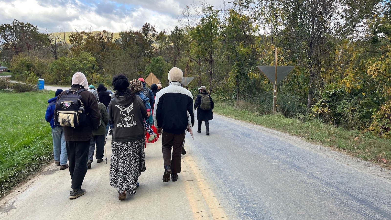
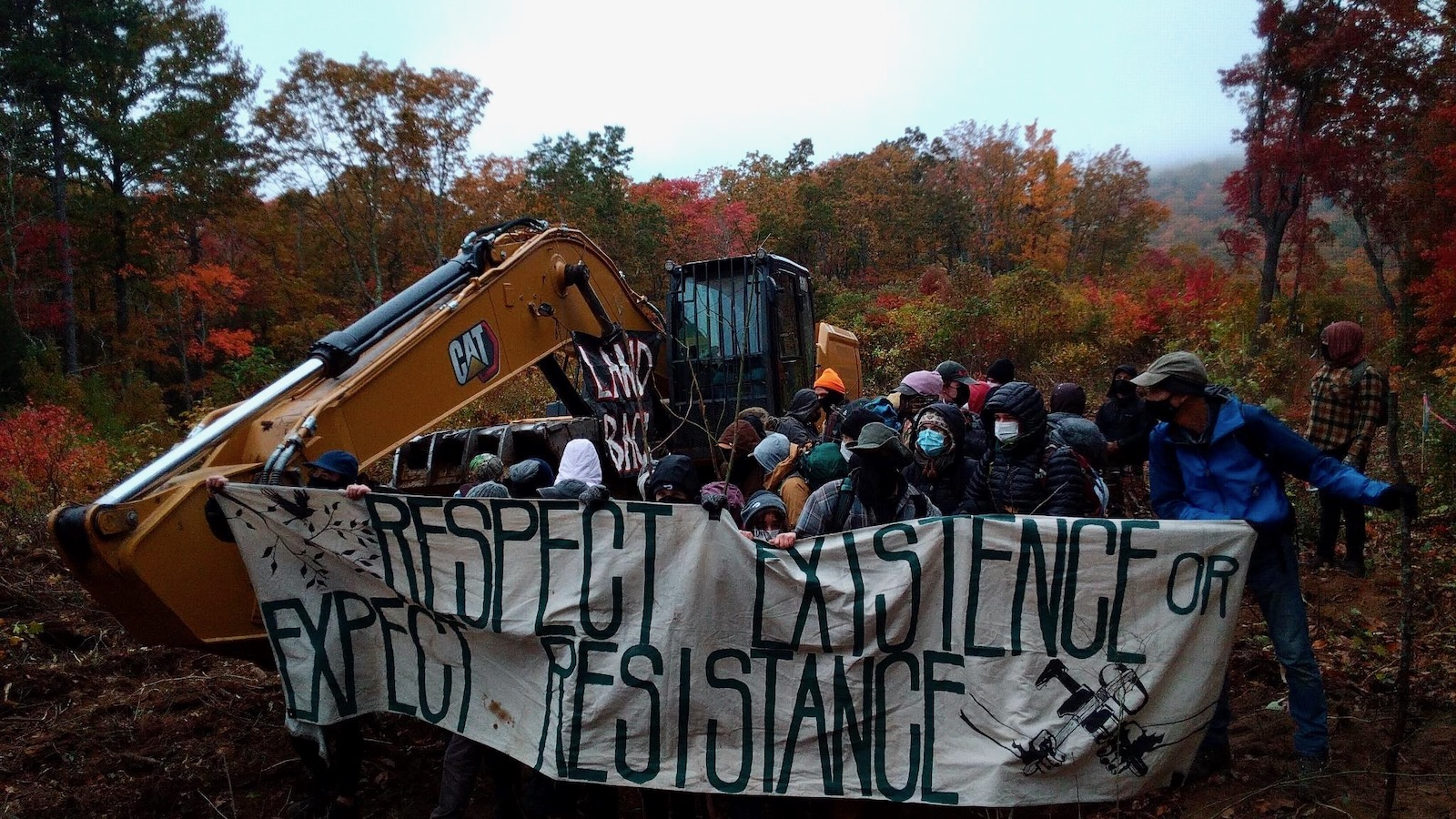
As day broke over the small mountain town of Elliston, Virginia one Monday in October, masked figures in thick coats emerged from the woods surrounding a construction site. Three of them approached three excavators and, one by one, locked themselves to the machines, bringing the day’s work to a halt. As they did so, several dozen of their fellow protesters gathered around them, unfurling banners and chanting amidst the groaning and beeping of construction equipment.
They made their way across the field, over patches of bare earth, around sections of rusty pipe meant for burial beneath the mountain. Eventually the metal tubes will form yet another section of the Mountain Valley Pipeline, which will soon carry 2 billion cubic feet of fracked methane from the shalefields of West Virginia to North Carolina each day. Their breath billowed in the crisp air. Beyond them stretched a bright blue sky, and mountains tinged with yellow. The past night’s rain pooled on the muddy and compacted soil beneath their feet.
Workers in highlighter-yellow vests and hard hats milled around, some looking amused, others frustrated. One or two engaged with the protesters, only to be told off by an irate site manager. A few miles away at the West Virginia state line, another three dozen or so activists did much the same atop Peters Mountain. One even managed to crawl under an excavator and lock herself in place, despite the cold. The others rallied around, enclosing her in a tight, protective circle.
Some might wonder why they bothered. After all, the project is, by the Mountain Valley Pipeline company’s estimate, 94 percent complete and will be wrapped up before summer. It stalled for several years amid legal fights over various permits, but Senator Joe Manchin, a moderate Democrat from West VIrginia, almost single-handedly revived it in 2022 in exchange for his support of key Democratic priorities. Since then, the Biden administration and the Supreme Court have all but assured its completion. With the approximately 303-mile pipeline approaching the final stretch after almost a decade’s work, it might seem hardly worth fighting at this point.
A large contingent of steadfast opposition begs to differ, and will enthusiastically explain why. The pipeline is six years behind schedule, about half a billion dollars over budget, and, despite promises that it would be done by the end of last year, delayed once again. The remaining construction is over rugged terrain, with hundreds of water crossings left to bridge. The company recently postponed, shortened, and rerouted its planned extension into North Carolina, a proposal long stymied by permitting problems with the main line. And, just last month, Equitrans, which owns the pipeline and many others across the country, was said to be considering selling itself. The road to the pipeline’s completion remains rocky, its opponents argue, with many opportunities to make finishing it as difficult as possible.
“We cannot let them destroy our land and water,” said a young woman named Ericka. Like many interviewed for this story, she gave only her first name out of fear of reprisal from Mountain Valley Pipeline LLC, which has begun suing protesters in a bid to silence them. She had brought her three children to occupy the land that day. “What are we going to drink? Where are we going to live? People have to come here and stop this.”
A protestor locked herself to an excavator, bringing work on the Mountain Valley Pipeline to a halt. Photo courtesy Appalachians Against Pipelines
Killing the project is their ideal outcome. Barring that, those who have for almost a decade packed public hearings, spent weeks at sit-ins and even lived high in trees for 932 days want to make building pipelines so time consuming, so expensive, so plain annoying, that fossil fuel companies and the politicians who support them think twice about greenlighting any more.
Even as pipeline crews continue steadily boring under rivers and felling trees, activists say each day they can delay construction is another day humanity delays the worst impacts of climate change. The increasingly grave personal and legal risks they face are, they say, worth it, if only for that.
“For five f****** years, we’ve fought you without fear,” sang the masked figures on Peters Mountain, and “we’ll fight you for five f****** more.”
Morning ripened over the ridge, and the fog rolled in, then out. The pipeline workers retreated, mostly without complaint — followed by the protestors’ calls of “Paid time off! Paid time off!” Some of those gathered began to sing: John Prine songs about beautiful landscapes stripped for coal, union songs, and striking miners’ ballads that reverberated through the same ridges long ago. When their voices grew weary, someone blared dance music through a loudspeaker as police cars rumbled up the gravel access road. They tried not to be afraid as the sirens grew louder, knowing the risk they had taken in coming here and knowing, as many said, that the time of act is now.
As the nation’s fracking boom reached coal country about a decade ago, pipelines carrying methane began to snake across the landscape. The Mountain Valley Pipeline, or MVP, met instant fury when Mountain Valley LLC proposed it in 2014. Opposition to the project drew a wide range of people, from farmers in West Virginia to Indigenous tribes in North Carolina, together in a united front. Some were alarmed by what it would mean for their land: Razed trees, disturbed landscapes, water running brown from the tap, and, in the end, a frightening risk of leaks and explosions. A pipeline in Pennsylvania run by one of the companies involved in MVP blew up late last year; a couple and their child suffered severe burns and barely escaped with their lives. Then there’s the longer term, irreversible danger of the 90 million metric tons of carbon dioxide that will come from producing, transporting, and burning all that methane over the 40 to 50 years the pipeline is expected to operate.
Residents along the project’s path joined academics, local organizations, and environmental nonprofits in filing lawsuits, seeking injunctions, and packing hearings. As they worked the legal system, other activists staged equipment lockdowns, organized rallies, and took to the trees for months-long sit-ins. The efforts led to some wins. Opponents repeatedly delayed construction, got various permits thrown out, and leveled allegations of water quality violations and illegal work on national forest land. In late 2018, the 4th U.S. Circuit Court of Appeals issued a series of rulings annulling the pipeline’s access to federal land and striking down a key permit. The next year, the Federal Energy Regulatory Commission ordered an end to almost all construction.
The project languished until the summer of 2022, when Manchin, a key Democratic senate vote who often challenges his party, made his support of Biden’s climate agenda contingent upon the pipeline’s completion. Last summer, he included a provision in the debt ceiling deal that effectively cleared away any remaining hurdles. A short time later, the Supreme Court lifted a stay on construction through a 3.5-mile stretch through Jefferson National Forest. Crews returned to work with renewed vigor.
So too did the protestors. Morning after morning, week after week, pipeline workers clocked in only to find their work impeded. Grannies locked to rocking chairs in the pipeline path, teenagers glued to construction equipment, worksites crowded by 20 to 30 people intent on stopping the day’s progress, more often than not, successfully. The campaign drew college students from nearby Roanoke, neighbors from across the mountains, seasoned organizers and newer activists with little experience, all part of a near decade-long coalition, all activated by the pipeline’s anticipated completion, and many ready to face legal consequences for opposing it.
Jammie Hale joined the movement to stop the Mountain Valley Pipeline more than 5 years ago.
Photo by Katie Myers / Grist
Jammie Hale is a bespectacled and bearded 51-year-old from Giles County, Virginia. Before he joined the campaign to stop the pipeline five and a half years ago, he was depressed and struggling with addiction. It didn’t help that the ruckus of construction invaded his waking and sleeping hours as it got closer and closer to his home, which lies within the 500-foot blast zone that could level his house in an explosion. “After a while, you hear all that, it kind of gets under your skin,” he said with a gentle intensity. “You build these angers up inside you, and how do you release these angers? Through self harm?” He became sleepless, consumed with visions of his family, and the land he plans to deed to his children, going up in flames.
When people began to organize, he and others in the community joined in. He found a will to live in the work. “I’m five years sober because of this project,” Hale said. “Because, you know, I wanted to be useful.”
Hale attended permit hearings, tested water, and, when people started sitting in trees, hiked up the mountain to support them. He brought home-cooked meals, blankets, and supplies, and rallied on the forest floor to boost their morale. “I instantly fell in love with these people because they were just so badass,” Hale said. He and his neighbors began to take more concerted action, filming and peacefully confronting pipeline company surveyors who came unannounced to survey their land for construction. Eventually, he found himself engaging in civil disobedience, fully aware of the risks he faces.
Hale is among a growing number of protesters the Mountain Valley Pipeline company has targeted with injunctions, a potentially costly legal hassle that could lead to jail time for anyone found on a construction site. Local authorities are taking an increasingly dim view of folks like Hale and show little hesitation in pursuing them for even minor infractions as the company continues to seize their land through eminent domain. These days, Hale supports protestors from afar by making signs and sharing food, among other things. There’s still some risk, he says, but if he lands in a cell or a courtroom, so be it.
“I’m not scared,” he said. “It’s kind of strange that they’re trying to get people for trespassing when they are the ones that have been trespassing.”
Another longtime pipeline fighter who goes by Larkin is no stranger to arrests, or to supporting people whose civil disobedience has landed them in court time and again. A soft-spoken health care worker from nearby Blacksburg, Virginia, Larkin, who is in her late 30s, has been fighting resource extraction in Appalachia since she was a teenager. She spent the better part of a decade marching onto dusty strip mines, locking herself to equipment, and demanding a federal ban on mountaintop removal coal mining. Ten years ago, that energy shifted toward the region’s multiplying pipelines. The Atlantic Coast Pipeline was proposed alongside the MVP; it met with similarly vehement opposition, and eventually died amid mounting legal costs and project delays. In short, protest worked, Larkin said.
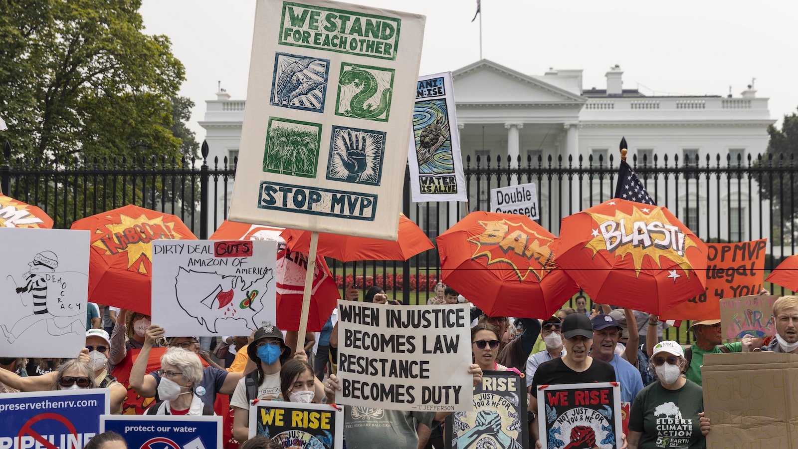
Protesters with Stop Mountain Valley Pipeline rally in front of the White House in Washington D.C. on June 8, 2023. Photo by Mostafa Bassim/Anadolu Agency via Getty Images
With the Supreme Court greenlighting the MVP, it seems to Larkin and others that there’s only one thing left to do. That is, throw their bodies upon the gears, in hopes of at least slowing things down for one more day, every day, for as long as possible, by force if nothing else.
“We knew from the get-go that a chapter of the fight requiring an escalated level of resistance is going to come if folks have any hope in pushing back,” Larkin said.
Despite the risks, Larkin, and many others, feel they are taking ownership of their future and their dignity. When we fight, they say, we win, and it’s better that fossil fuel companies know their encroachments won’t go unchallenged. Larkin also feels it will deter future projects like the MVP. Without organized opposition, she feels the whole regulatory system will continue to rubber-stamp permits until the ocean overtakes Washington.
“Old men with no thought to the future are ruining things for all of us,” Larkin said. “It really is down to us to just be mad. And do it with our bodies and be in the way.”
She knows she’s never far from becoming a target of the Mountain Valley Pipeline company’s ire. Over the years, she’s seen friends locked up and beaten down at various protests, and sometimes it makes her feel old. After so long in the fight, her knees and back ache, and she can’t spend hours sitting on the floor painting banners like she used to. When she began this work, she burned herself out quickly, believing that the world would end if she didn’t give everything she had.
“When it’s so obvious that the world is on fire, it does feel like you have to put it out on the table all at once,” she said. “Just like, why think about the future, we have no future, kind of thing. And here we are, eight years later in this fight.”
Yet there are moments, even now, when the pipeline seems inevitable, when she feels the joy of having taken a stand, of having made lifelong friends, of having done the right thing.
“I freaking love to have daybreak on a new blockade that has gone up in the night,” Larkin said, smiling. “And I think the other thing that I love is that I have really met and built real relationships of trust and solidarity with neighbors, people in my community who I wouldn’t have otherwise known.”
The pace is fast and the emotions run hot right now, but the stakes have felt high for a long time, Larkin said. She’s watched friends get sick, both from burnout and from the environmental risks of living near extraction, and watched some die of environmental illnesses and illnesses of stress and poverty. When trying to pinpoint exactly how the fight has lasted so long, Larkin points to the constant influx of new activists, particularly energized young people from nearby towns and colleges, and from other, similar campaigns.
One activist who goes by Gator had only just turned 18 and drifted north after a working-class childhood on the Gulf Coast of Louisiana. He felt disconnected and adrift at a military high school, beset by a gnawing sense of climate apocalypse and a bleak future. “My home is disappearing,” he said bluntly.
Gator found his way to the Weelaunee “Stop Cop City” occupation in Atlanta last summer. The connections he made there led him to the woods of Virginia and West Virginia, where he camped in the pipeline’s path and met people who shared his feelings of desperation and urgency.
He felt himself cross a Rubicon of sorts during a stint in jail after his arrest at another demonstration. He spent several days locked up, not knowing how much time had passed and listening to guards mock the people around him. As he sat there on the cold concrete bed, he knew there was no return to regular life, to regular expectations for himself.
“It used to be that you’d be like, ‘I want to keep my nose clean, because I have a chance of having a career and having, at least for me, and the people I love, a comfortable life,’” Gator said. “But even that is disappearing.”
Protestors head toward a Mountain Valley Pipeline construction site in the mountains near Elliston, Virginia, in October 2023.
Photo by Katie Myers / Grist
The atmosphere in Elliston was, like the movement itself, at once nervous and defiant. Like environmental justice advocates most everywhere, those standing up to the Mountain Valley Pipeline are facing ever greater restrictions on their protests and increasingly harsh punishment for their actions.
In September, Mountain Valley Pipeline LLC filed a lawsuit against more than 40 individuals and two organizations — Appalachians Against Pipelines and Rising Tide North America. The suit seeks more than $4 million in damages and a ruling prohibiting the defendants from accessing construction sites, planning demonstrations, or raising funds for protest activities. The company said it decided to sue because protestors endanger themselves and workers, and because they’re breaking the law.
“If opponents were truly interested in environmental protection,” said MVP spokeswoman Natalie Cox, “they would have engaged with us to address their concerns through honest, open dialogue, which we respectfully offered on numerous occasions, rather than wasting agency resources and burdening the courts to support their myopic agendas.” Cox also blamed protesters for disrupting landowners and limiting the region’s economic opportunities.
Such lawsuits — which activists and their attorneys often call a strategic action against public participation — are usually filed by corporate or government entities against people who speak out on a matter of public concern. Those fighting the pipeline say the suit is intended to chill protest and intimidate them. Mountain Valley Pipeline LLC has been regularly adding defendants to the suit, often after identifying them near protests or reading their names in the news. Many protesters have been charged with felonies in recent months, all for blocking construction.
Despite a relative lack of trouble at the Peters Mountain lockdown – authorities arrested two people and quickly released them – the arraignment later that week proved more contentious. The two young activists were unexpectedly re-arrested and prosecutors slapped each of them with a felony kidnapping charge – presumably, protesters say, for asking construction workers to leave their vehicles – and held without bond.
According to Appalachians Against Pipelines, another protester, who goes by Pine, turned themself in on a felony warrant; they were charged with kidnapping and theft for holding up a work vehicle. A judge set bail at $25,000. Another protester was sentenced to six months, with three of them suspended, for similar charges. They are free pending an appeal.
“This system is seeking to doom us to a future that will not even exist,” Pine said in a statement. “However, there is solidarity everywhere … these ridiculous charges that I received do not make me afraid, since I know I do not stand alone.”
Fear of arrest and imprisonment remains a restless undercurrent for many activists, said a young organizer who gave only her first name, Coral. She stepped away from fighting pipelines on tribal land to answer a call for support in central Appalachia..
Protestors gather at a Mountain Valley Pipeline construction site in rural Virginia in October, 2023, an effort to delay its completion.
Photo courtesy Appalachians Against Pipelines
“I’ve been grappling with the repression piece a lot because it is working,” said Coral, who identifies as Indigenous but would not state her affiliation for fear that it might help identify her. For her, and many of those fighting alongside her, the effort to stop the pipeline is a commitment to protecting unceded Indigenous land, and to building a world free from old, colonial, and extractive social structures. That obligation weighs heavily on her, though. The killing of an environmental activist at an ongoing forest blockade in Atlanta and the ceaseless violence against Native land defenders worldwide is never far from her mind. “Our people were persecuted and killed for fighting for our land,” she said.
And yet, despite it all, the pace of protest has increased since construction resumed. Few weeks go by without people locking themselves to equipment, blocking the pipeline route, or picketing banks that support the project and the company building it. Despite several frightening incidents, including one in which crews reportedly felled trees dangerously close to an activist, the blockades and lockdowns continue. The hope, many activists said, is to draw a critical mass of supporters to the region. The fight, they said, is far from over, and they hope to bring the same kind of energy sparked by the massive Dakota Access Pipeline protests.
In Elliston, as the crisp October day warmed, the crowd was as energized and raucous as ever, echoing demands that have evolved over decades of environmental organizing in central Appalachia. Many hands unfurled colorful banners connecting the fight against climate change to movements opposing war, genocide, incarceration, and the theft of Indigenous land. Before long, though, several police cars slowly rolled up the road from the main highway, blocking the group’s exit. As officers stepped from their cars and made their way up the hill, some protesters with children in tow began to worry about their safety but remained for the moment.
As the police amassed, a young person of about 20, bundled in warm clothing and locked to an excavator, called down to the crowd. Their face couldn’t be seen, but their voice sounded small and very young. “I’m here because…these mountains are beautiful,” they called, laughing. “Appalachia is beautiful. This planet is beautiful!” Some in the crowd, though anxious, smiled at the voice speaking for them. The crowd held one another and swayed in the breeze as the drums started up again.
“The judge has had it up to here with y’all,” one exasperated police officer remarked as some in the group talked him down from arresting everyone in sight, mothers and children and all. Other officers took photos of license plates and threatened to increase their retaliation if they saw any of the cars at another protest.
When the group moved on to a neighboring plot owned by someone sympathetic to their cause, the police followed them, threatening to cite anyone who stuck around. Everyone knew that probably meant being added to MVP’s lawsuit. They decided to move along, but vowed to return another day.
A huge EV factory is coming to west Tennessee. Here’s how locals are ensuring they benefit.
“Blue Oval City” sounds like some kind of fantastic, utopian megalopolis of the future. In reality, it’s a massive automotive manufacturing complex that will provide several links in the EV supply chain. The joint venture, between Ford and Korean company SK Innovation, promises 6,000 good-paying jobs for residents of the small, rural communities around Stanton, Tennessee. Many expect it to benefit surrounding towns like Covington, Brownsville, and Jackson as well, while reaching south into Mississippi and north into Kentucky, too.
But the multibillion-dollar project raises complicated feelings for many in the working-class, largely Black communities that dot the farm country and marshy bottoms of west Tennessee. They pride themselves on a slower way of life, and feel lucky to have good drinking water from a reliable aquifer. Development on such a large scale will, they fear, change the community, suck up water and electricity, and prompt an influx of newcomers and development.
They are only the latest to face uncertainties with energy transition projects, which, from solar fields to wind farms, have prompted reservations about their size, industrial activity, and environmental impacts. But rather than accept their fate, the constellation of towns orbiting Stanton are sitting down with Ford and SK to negotiate a binding agreement that will ensure they benefit from Blue Oval City as much as the companies do.
During a series of community meetings held over the past few months, the coalition has drafted a list of stipulations, called a community benefits agreement, that it wants Ford/Blue Oval SK to abide by. It is asking for community resources like youth facilities, support for road maintenance, and apprenticeship pathways run by local union chapters. It also seeks a binding assurance that the joint venture will dispose of its waste properly. And although Ford has announced many community programs, local residents want the automaker to give them some say in such things.
“They didn’t really reach out,” Michael Adriaanse, who serves on the committee drafting the agreement, said of Ford’s efforts. “I know a lot of people who feel like it happened overnight.”
So how does such a process begin? Generally with meetings that bring stakeholders together to draw up a list of demands in a broad public conversation the company cannot ignore.
“The argument a community can make is, ‘If you want our resources, you have to contribute back to the health and welfare of the community you’re gonna be a part of now,’” said Kathleen Mulltigan, who leads the National Labor Leadership Initiative at Cornell University. “What we’re really trying to do is bring real democracy into the economic realm, because a lot of the work of shaping the economy happens without workers having any voice in it.”
Ultimately, community benefits agreements, or CBAs, are a contract between a corporation and coalition of local organizations that gives the community, through binding arbitration, leverage to ensure the commitments are kept.
Historically, CBAs have been used by those impacted by the entertainment and sports industries, which tend to get big municipal tax breaks and public funding. Some of the first were negotiated in Los Angeles in the early 2000s to address, separately, a sports arena and an entertainment district. After exhaustive negotiations, residents achieved many of their goals, including higher wages, guaranteed affordable housing, and revolving loans for local business. CBAs have since spread nationwide, with folks in Nashville negotiating a high wage floor, onsite childcare, and other provisions at Geodis Park, a $275 million stadium being built for the Nashville SC soccer team.
Now, CBAs are increasingly being used to address clean energy developments. According to the Sabine Climate Change Law Center at Columbia University, more than a dozen have been signed since 2015, many of them in the last three years. The contracts resulted in projects agreeing to give preference to local hires, and in companies sharing revenue with the county in which they operate. An offshore wind facility in Maine even underwrote rural broadband access.
Vonda McDaniel, the president of the Central Labor Council of Nashville and Middle Tennessee, is helping to formulate Blue Oval agreement and plan town halls. The process has been lively. “We haven’t had a whole lot of wilting flowers that have showed up at our meetings, to be honest,” she said.
One reason for that is that locals already see changes. “The community is feeling a bit squeezed; there’s heavy equipment up and down the road every day,” said McDaniel.
Farmland counties in the region known as Middle Tennessee endured rapid urbanization when automakers arrived in Spring Hill, south of Nashville. As investment increased and people began moving in, housing costs skyrocketed. They’re beginning to creep up around Stanton, too. McDaniel says a CBA could forestall that.
“Community benefits agreements are based on the power and leverage that communities build within themselves,” she said. “They’re not just gonna give you a list of things you say you want.” In her mind, these agreements help ensure a measure of democracy in a part of the country where voter disenfranchisement, especially in rural, Black communities, is high and private interests have the ear of state government.
The Blue Oval project received a $9.2 billion loan from the Department of Energy. As clean energy funding and incentives have proliferated under the Inflation Reduction Act and Bipartisan Infrastructure Law, much investment has gone to the Southeast and America’s vaunted EV “Battery Belt.” The region’s famously climate-unfriendly governors have opened their doors wide, with Tennessee Governor Bill Lee seemingly keen on snatching the automaking mantle from the Great Lakes. With $900 million in public incentives approved by the Tennessee legislature, it’s the largest single manufacturing investment in the state’s history.
Amidst the green boom, many have speculated that a part of the South’s draw is its generally lax environmental and safety regulations. Tennessee is a “right-to-work” state; such locales typically support lower average wages. Tennessee’s preemption ordinance also prevents municipalities from enacting worker standards beyond what state law requires.
This does not mean publicly supported clean energy projects in the South are doomed to a lower standard than those in other places. The president of the Nashville chapter of the United Auto Workers Union has promised that Blue Oval City will be a “union facility.” The Inflation Reduction Act and bipartisan infrastructure law require those seeking federal funding to submit a “community benefits plan” outlining how they will invest in domestic labor, local communities, and diversity, equity, and inclusion initiatives. Although similar to CBAs, they’re not the same. Advocates of such arrangements say CBAs are needed to secure accountability and transparency, and to give communities direct input into projects that impact them.
Will Tucker works as the Southern Programs Manager with Jobs to Move America, a national labor advocacy nonprofit. It recently negotiated a CBA with New Flyer, an electric bus manufacturer in Anniston, Alabama, and Tucker feels confident this approach to the transition can work in the South.
“What sets a real community benefits agreement apart from a dressed up community outreach program by another name is the element of negotiations with the company,” he said. Though many companies will set aside funding for local sports leagues, schools, and the like, Tucker considers such moves more of a PR strategy than a way of giving the community power.
If community organizations can present a united front, that pressure usually pushes the company to negotiate, though in some cases, protests and demonstrations heighten the stakes. Michael Adriaanse hopes such pressure will send the Blue Oval City CBA over the finish line.
Ultimately, for a CBA to work, the company in question must sit down with the community. Adriaanse said the coalition invited Ford representatives to a town hall to discuss preliminary demands, but it didn’t work out. McDaniel speculated that the company’s ongoing negotiations with United Auto Workers, which recently concluded a strike, may have slowed some things down. There’s a long road ahead, but Adriaanse and McDaniel are hopeful that with a strong enough coalition, the company won’t be able to dodge any longer.
The coalition still plans to go to the table with Ford, with a complete draft of the agreement in hand, early in the new year. Even if the effort is not immediately successful, community members say, the relationships they’ve built with one another will only get stronger, leaving possibilities for further organizing open down the road.
Nursing homes in Thurston County will need to increase staff levels to meet new federal standards
On September 1, 2023, the Biden administration issued a proposal to establish comprehensive staffing requirements for skilled nursing facilities (aka nursing homes) across the country.