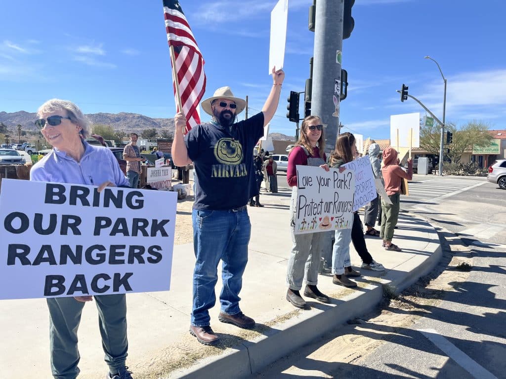
America’s 433 national parks, monuments and sites evoke images of scenic mountains, forests, waterfalls and peaceful family vacations. However, during Pres. Donald Trump’s second term, budget cuts, layoffs, fee increases, lawsuits and other conflicts have roiled the National Park Service.
Although the NPS recorded more than 323 million visits in 2025, with 26 parks setting visitation records, the Trump administration has proposed reducing the agency’s funding by $736 million, or 25 percent, in the 2027 fiscal year. The suggested cut comes after the NPS already suffered significant layoffs, a hiring freeze and reduced funding in the 2026 fiscal year.
“The 2027 budget request for the array of outdoor recreation programs and a wide range of other uses across the (Interior) Department will ensure Americans can enrich their lives in a multitude of ways across our vast public lands,” Interior Secretary Doug Burgum told the U.S Senate Appropriations Committee on April 22.
John Garder of National Parks Conservation Association (NPCA) agreed. “After a year of deep staffing cuts, dwindling resources, and attacks on history and science, park staff are already at the brink. Park maintenance needs are growing, protections are eroding, and visitor experience is declining. This proposal would only accelerate the damage,” he said.
Both houses of Congress are considering Trump’s proposal and the full federal budget.
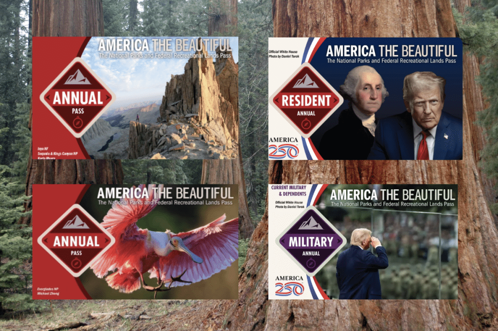
The America the Beautiful pass has shifted its theme from nature (pictured on the left on the 2024 and 2025 cards) to Pres. Donald Trump (pictured on the right on 2026 cards).
Park passes protested
The National Park Service’s $80 America the Beautiful Pass has stirred controversy. Providing unlimited entrance to national parks, monuments and forests, the pass usually depicts scenes of nature. However, the 2026 pass instead features portraits of America’s first and current presidents, George Washington and Trump.
This has led Trump opponents to place stickers on passes to cover Trump’s face. In response, the Interior Department declared such passes “void if altered.”
The Center for Biological Diversity filed a lawsuit claiming that the new design violates a federal law requiring the winning photo of the National Parks Foundation’s annual photo contest to appear on the pass.
“Blotting out the majesty of America’s national parks with a closeup of his own face is Trump’s crassest, most ego-driven action yet,” said Executive Director Kierán Suckling. “America the Beautiful means wild rivers and majestic mountains, not a headshot of a bloated, fragile, attention-seeking ego. There’s nothing beautiful about that.”
White House spokesperson Anna Kelly responded. “Instead of filing frivolous lawsuits, this leftist group should be thanking Pres. Trump for enhancing opportunities for Americans to enjoy our beautiful national parks,” she said.
While the lawsuit is pending, sale of the Trump-branded passes continue.
Higher fees for foreigners
Additionally, the NPS raised the annual pass price from $80 to $250 for non-US residents. Alternatively, foreign visitors can enter major parks like Yosemite, Sequoia and Kings Canyon for seven days for $100 per person plus the standard $35 per vehicle.
Trump mandated the change through an executive order issued last July.
“President Trump’s leadership always puts American families first,” said Burgum. “These policies ensure that U.S. taxpayers, who already support the National Park System, continue to enjoy affordable access, while international visitors contribute their fair share to maintaining and improving our parks for future generations.”
The change has required park entrance staff to routinely check the identification of visitors. NPCA claims the policy has caused long lines, confusion and a loss of tourism business which will intensify in the peak summer season.
“It’s painfully obvious that the new non-resident fee policy needs to be put on hold until the challenges facing park staff and visitors are addressed. This is an absolute mess and was entirely predictable given the lack of transparency, public input and analysis of real-world impacts,” said Emily Douce of NCPA.
Free park entrance days changed
The NPS has altered its free entrance days for 2026, removing Martin Luther King Junior’s birthday and Juneteenth from the list that includes Veterans Day, Memorial Day and Independence Day. However, the agency added a new fee-free day on Trump’s birthday, June 14, but only for US residents. Foreign visitors must still pay the standard entrance fee plus $100 apiece for the most popular parks.
Former ranger sues over firing
Dr. Shannon Joslin, a biologist and former Yosemite ranger, has sued the federal government over the loss of their job in 2025.
Joslin, who is nonbinary and uses they-them pronouns, was part of a group that hung a transgender pride flag on El Capitan for two to three hours on May 20, 2025. Yosemite’s superintendent announced a ban on such displays the next day, and the park fired Joslin in August.
“The Trump Administration’s hostility toward trans rights is well-documented,” Joslin’s complaint alleges. “This vindictive campaign violated Dr. Joslin’s First Amendment and Privacy Act rights and continues to chill their expressive conduct and speech.”
Joslin seeks reinstatement, unspecified damages and attorney fees. An Interior Department spokesperson defended the firing. The case is pending.
National Park Service rangers and staff protest layoffs outside Joshua Tree National Park. Photo by Matt Johanson
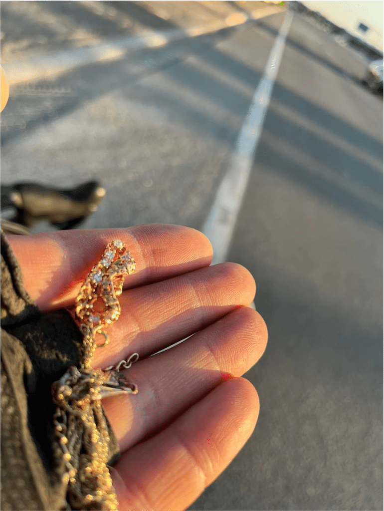
Bullets, Gold and Avocados: Roadside Finds From a Bike Commute
Spring is here, and there could be gold and diamonds in your future if you ride your bike. Just put on some gloves and a jacket.
It’s not just hyperbole, these are actual items I found during my bike commutes between Reno and Carson City from spring to summer in 2023. During that time, I found a bounty of valuable gifts, so many I felt compelled to stop, take a picture and write about it on social media.
I was commuting a few days a week from Reno to Carson City for work, and as I rode below our majestic mountains and watched the road, I started to see a different side of Washoe County, one that highlighted the scourge of driving and the solace of the bicycle.
Also during this time, I was battling a push by leaders to make cycling harder.
There was a plan by the Regional Transportation Commission (RTC) to make a safe connection for students to ride on Center Street between the university, Downtown and Midtown. The RTC even celebrated the kickoff of the project publicly.
But then, suddenly, the RTC changed leadership and the city, RTC Washoe and casinos colluded with false and misleading information to crush that plan, ignoring their own traffic studies, wasting a decade of planning and hundreds of thousands of taxpayer dollars. I was extremely frustrated. I was flabbergasted that our leaders would put our children’s lives in danger, and with every pedal push, my anger grew.
As a parent, and the president of the Truckee Meadows Bicycle Alliance, I went on a rampage, stirring the pot with news and opinion pieces, calling Reno the only city in America without a bike path through downtown. These little daily roadside treasures were a reminder to keep going and a respite from my rage.
In the end, we won. While we didn’t get the planned bike path on Center Street, the city of Reno took dramatic action, expanding the one-mile bike path idea into a five-mile network of streets–and they started immediately.
They did install a pilot project on Virginia and 5th Street during the Conference of Mayors (to show that we can have bike paths and we do care about safety). A parking-protected demonstration project on 5th Street became permanent. So, now the Biggest Little Bike Network through downtown is planned for implementation next year, including painting the entirety of Virginia Street through downtown green.
So, if you choose to spend less time behind the wheel and more time gripped to the handle bars this summer, you might find some treasures of your own. Here’s just some of what I saw on those sunny rides.
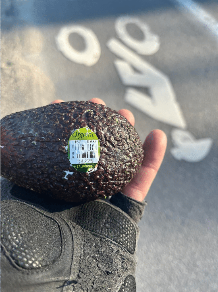
The organic avocado was at a three-way intersection. They must have rolled out of the back of someone’s truck as they turned and I was the hapless beneficiary, brave enough to stop in the road and pick it up.
It wasn’t all fun things I saw from the saddle. Some things were more curious, and even concerning.
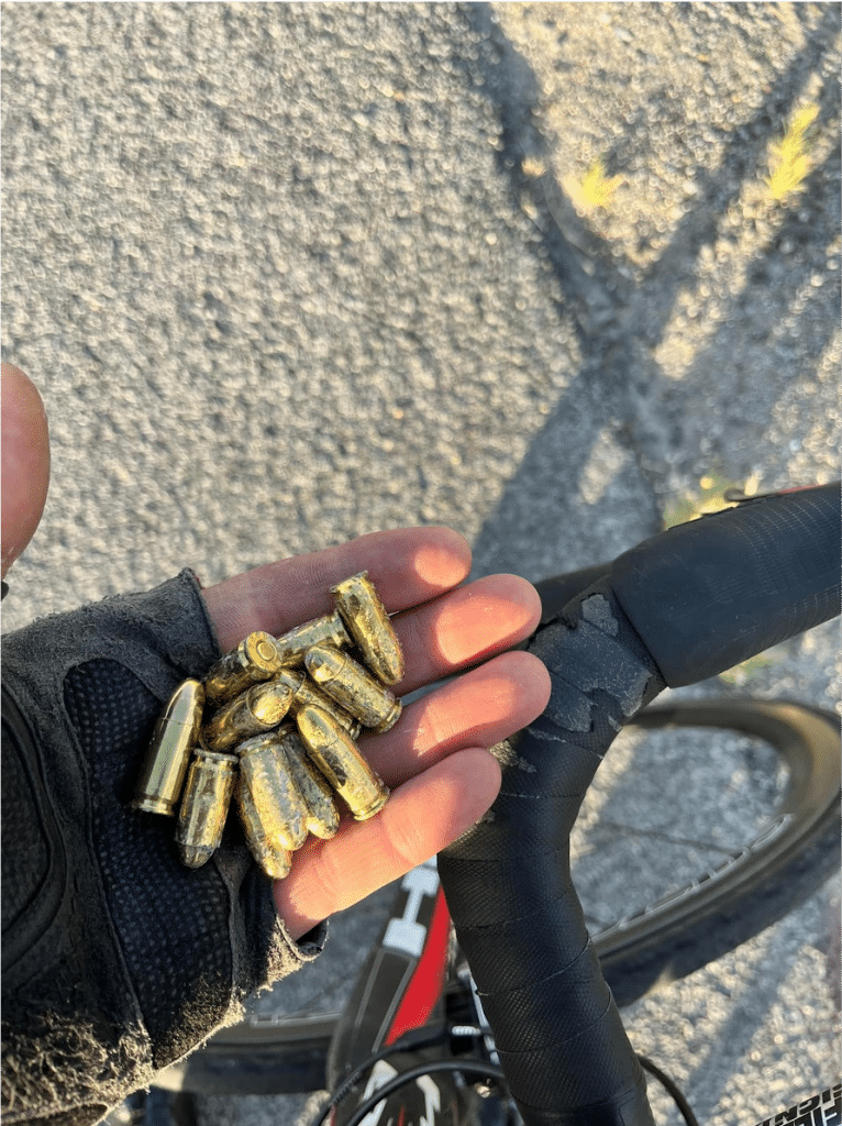
One day, there was a blasting tail wind through Little Washoe Valley pushing me like a rocketship, rolling on the skinniest and hardest of tires. I was flying. Cars weren’t going much faster. But unlike them, I was silent except for my pumping breath.
When you ride like that, you keep your eyes peeled as tiny obstacles can cause you to suddenly swerve into traffic, give you a flat that can lead to road rash, cost you time and temporarily end a really fun ride. But that did not slow me. I was in the moment. At 30+ miles per hour through Little Washoe Valley, suddenly, a scattering of shiny, pointy things zoomed into view. I weaved and dodged them. ‘Were those what I think they were?’
I checked over my shoulder, stopped and rode back. Because I’ve learned that when you see things once, you may never see them again.
As I held the bullets in my hand, I looked at the road, the nearby tree and off into the horizon where a fun little story started to seep into mind: A guy was driving his truck drunk, got pulled over by cops. The drunk driver pulled out a gun and in the ensuing struggle, the cop won and dumped the offender’s bullets out of his gun on the side of the road and wrestled him to the ground.
I gave the bullets to my daughter Aeva. She put them on her workbench, preciously on a furry pink piece of cloth and they sat there for years–like a shrine. She was probably wondering what they mean (the difference between life and death). Now, she keeps just one of them in her room standing on a shelf, upright and proud. It’s her power. To me, it represents the commute with cars, dodging bullets (cars) every day and staying alive for her.
Wildlife
Ever had deep, daily compassion for roadkill? Try riding your bike. I’ve watched hawks, coyotes, calves, marmots, frogs, lizards, snakes, chickens, horses, deer, dogs and cats all decomposing, day after day with the glimmer of life in their eyes gone. Humanity is callously killing countless animals with cars every day, just so we can get to work.
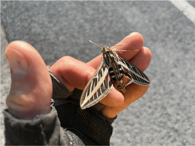
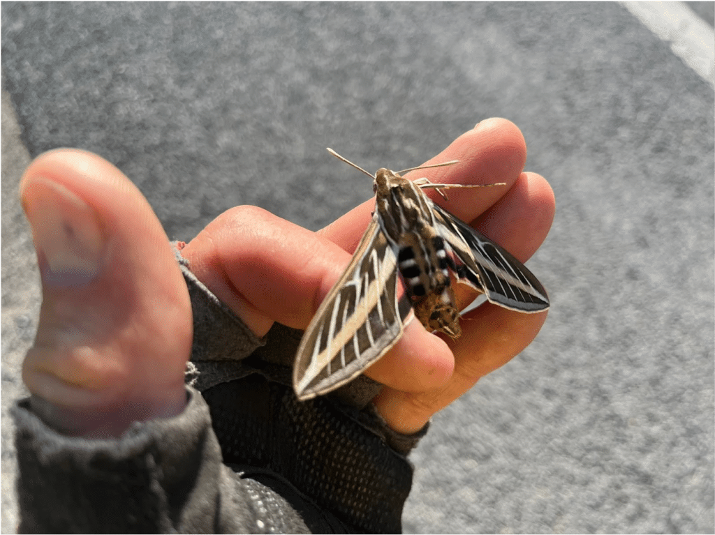
Seeing them first hand from the saddle is one thing. It’s even worse when they are still alive–barely. One day there was a moth struggling on the side of the road. I stopped and picked it up.
At the time, I was not sure why I wanted to console this little beautiful dying creature. I celebrated in silence the final moments of its life on Earth, in solidarity. I wondered if it could feel my warm fingers. Somewhere deep down, I felt like that insect. I could be squashed at any moment by a car too–my only mistake trying to get somewhere. I could be slightly grazed and immobilized with a broken wing at any moment on the road.
As a cyclist on the side of the road, death was passing by within feet of me every few minutes for hours on end. This is how I became more aware of the plight of other vulnerable road users–and sometimes we fight back.
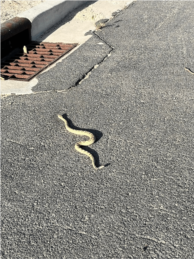
Out in Carson City, while climbing a hill at slow speed, a rattlesnake reared up at me. I swerved just in time, rode past and turned back to grab a pic as it slithered off into the sewer. Sometimes I think drivers think of cyclists like sewer dwelling rattlers who don’t belong on the road.
Cyclists aren’t dangerous like rattlesnakes. Drivers are the apex predators, squashing us and wildlife without even batting an eye. Sure, cyclists make pedestrians and other animals nervous, but we don’t kill people and animals like cars do.
Here is a good example. Once, while having a peaceful ride through the park, my daughter Alara hit a goose on her bike. It got stuck between her front wheel and feet. It must have seemed like an eternity of pain for her. Both of them were absolutely fine. We laugh about it to this day, and importantly, no one died. If it was goose vs. car, the story would be very different.
Fear of Cars
Cyclists are also drivers (we have cars and pay road taxes too), but we are different from people who only drive cars. Unlike drivers, we feel an intense difference of crossing the threatening threshold of peaceful rural roads to major urban traffic.
One day, after riding through the pastures of Washoe Valley, I arrived at the intersection of Mount Rose Highway and Virginia Street. This is where I’m now suddenly faced with constant 60-mile per hour traffic and eight lanes and cars coming from six different directions, while we cyclists stand still at intersections. As I stood there, cars wheezing by me, I dreaded entering the urban jungle. How could I quantify this stress of crossing from rural roads to the urban?
There is a heart monitor in my wristwatch. Later that night, I brought up my Strava account and when I looked at my heart rate as I crossed Mount Rose Highway into Reno, there was an intense spike in my heart rate. I suddenly had to navigate more traffic at high speeds. To relieve my stress, I started to wave at EVERYONE in a car in the urban environment, thanking them for not killing me. I find Reno drivers are pretty compassionate, even letting us roll through stop signs. I made a short video about why letting cyclists roll through stop signs is safer for everyone.
Over the hours of thinking about why some drivers don’t like cyclists, I realized that many drivers are scared that they will hit us, and that fear comes out as anger. Instead of being mad at each other, we should be mad at the road managers who pit us against each other with their poorly designed roads. Most roads in Nevada don’t follow the Federal Highway Administration’s Bikeway Selection Guide.
Drivers and vulnerable road users need to stop being mad at each other and start demanding that RTC Washoe, City of Reno, City of Sparks and Nevada Department of Transportation start following best practices on every road, and pass laws that protect cyclists. Instead lawmakers are killing such legislation and passing new restrictions on vulnerable road users like they can’t do wheelies and need bike bells, as if that is the problem. If they would just do what is right and fix our roads, we would ultimately have safer streets and happier taxpayers.
Fear (and Rescue)
No drivers have ever honked at me or threw anything at me. I was chased once by someone in a car through downtown Reno, but it’s easy to get away on a bike. Most drivers give me plenty of space. The fear that I would be assaulted would crop up every time I heard a car coming up behind me.
“I hope they don’t hate me for being here. And if I do get hit, will someone pick me up?”
On one of my first commutes from Carson, it was so windy that the I-580 freeway was closed. That means heavy winds whizzed through Washoe Valley and all the trucks were routed onto the frontage road where I rode. So, as I was leaning sideways into 40-60 mile-per-hour winds on my left, a giant truck would pass me, sucking me into the side of the truck and forcing me to lean the opposite way to the right. Then the truck would pass and the winds would throw me to the right, threatening to send me into the rocks and bushes.
There was less than a foot of shoulder to work with. I swore out loud every time a truck passed as if I was dying. I thought I was going to die.
On one of my last commutes home from Carson, I decided to head up over Virginia City in February. I climbed all the way through the historic town and out and up along the lonely road to the frozen summit at dusk. The road was silent and ice-covered. I was beat, cold, had nothing to eat and I was fading into the night with no lights. I caved, stopped and sat on the gray metal guard rail above the canyon in silence among the pinions to ponder my non-existent options.
A white truck came up the road. I instinctively stuck my thumb out, thinking a rural truck could care less about a guy on a bike. But he stopped. I threw my bike in his truck without asking and got in. It was Denny Dodson behind the wheel. He was a Virginia City government employee who was in a national news story I wrote about how the ghost town was “old fashioned” and lax with its accounting of taxpayer money.
He had also surely seen another of my stories about how the Virginia City school district had prostitution and a bar to thank for funding high school. I kind of fancied myself as a modern day Mark Twain, writing about Virginia City tongue and cheek. Maybe Denny liked it? Bottom line, I don’t think Denny recognized me because he didn’t throw me out of the truck. He drove me down the windy road at night and dropped me off at the base of Geiger Grade.
“You be careful now,” he said, in a way that made me feel like he was genuinely worried.
Thank you for saving my life, Denny.
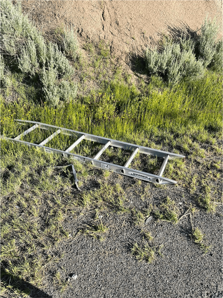
Some Trash (and a Ladder)
There are far too many things that I have come across on the road to remember them all. The mountains of things eventually give way to big-picture thoughts of America. What does all this stuff on the side of our roads say about who we are?
Between rotating pedals, I often stare back and forth at the beauty of the mountains and the roadside. The stark contrast became evident. The mountains were covered in pines, snow, and purity. There were probably back country skiers frolicking up there.
But down here, on the side of the road, we have endless cigarette butts, alcohol bottles and fast food wrappers. It’s sad. People who don’t care about our environment are in cars, smoking, drinking and eating fast food and leaving a trail of their vomit behind. They don’t care about the health of their bodies, where we live or anyone else who wants to enjoy our planet.
Alcohol bottles, mostly empty and discarded, some filled with yellow liquid. That scared me a little, knowing that people like that are on the road, guzzling booze, pissing it back in bottles and throwing them into our shared spaces.
Looking back, I wish I had taken pictures of the nasty trash on the side of the road. There was simply too much of it and it became part of the scenery of America. It’s not in piles, but it is constant. Drivers don’t see it because they pass by so fast. It’s still there. Take a look sometime.
There was also an abundance of our work wares. Gloves, probably left on someone’s roof, showed the mindset of workers as they rushed from job to job with their rough hands. There was a ladder laying in a frog ditch in Washoe Valley. BBQ lids were in excess supply on the side of the road. Car parts, giant nails and glass were daily hazards. That encouraged me to write endlessly to county officials to urge them to clean bike paths. Eventually they bought a little bike path street sweeper. Win.
Pillows, stuffed animals and kids’ toys laid peacefully on the shoulders among the alcohol bottles and cigarette butts. I once picked up an unused road flare, probably left by an officer for some hazard he encountered.
A knife under a bridge told me the story of a person fighting for their life. Used diapers shared the imagination of a mom, barely getting by, changing a child in the back of a car and then throwing the poopy diaper out the window in disgust, only to cause me disgust later.
Tie downs flapped and frayed, forgotten, and fell off after the things they tied down started flopping. Hats flew off as people stuck their heads out the window to barf. Expensive tools, shiny and appealing, were left on car bumpers only to be jostled off, forgotten. Lost a tool? No biggie. We Americans will just buy more. I often stopped to pick up some tools only to find that they were destroyed by cars driving over them.
There were lots of plastic container lids too – showing that people put things in bins so that they wouldn’t lose stuff, only to lose the lids that protected their things that they ended up losing anyway.
“This is America,” I thought.
What It Means
To me, the trash heaps and dead things say we are a society that collects so much stuff, we don’t care enough to secure it and we don’t care about killing stuff. We will just buy more and act like the people and animals on the roads are expendable.
In just about any other country, the things at the side of the road would be picked up by people who are walking or biking and put to good use (not just have articles written about them). Not in America. Not that many people walk or bike because we don’t value health, the outdoors or build roads that are safe for biking and walking. So, the bounty of roadside treasures just sits there, building up and decaying in a rotting culture.
The message: Slow down, see the place where you live, and you might be surprised. You might care more and write to your elected officials to use your taxpayer money in a safer, more sustainable way.
This road is big enough for both of us–cyclists and drivers. Just give us three feet (it’s the law) and maybe a protected bike lane here and there.
This period of commuting from Reno to Carson by bike was one of the most amazing periods of my life. Our road treasures, trash, safety, threat of death and anger led to great anxiety that eventually gave way to the closest I may ever come to zen.
You can feel it too. Ride on.
If you are looking for tips for how to start bike commuting or tips for existing bike commuters who face challenges, the Truckee Meadows Bicycle Alliance is hosting a panel of experts on April 29, 7 p.m. at Craft Beer and Wine called Drive Less, Ride More – learn how you can do it. Register here.
“The land has been calling us back, and we are answering that call.”
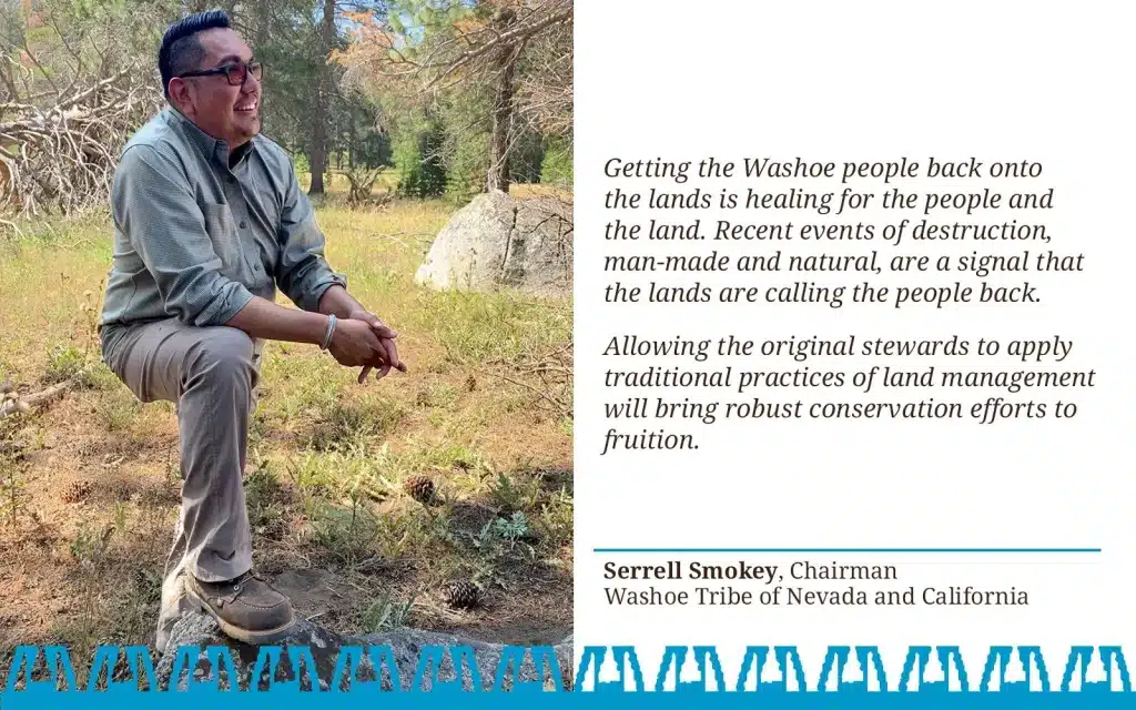
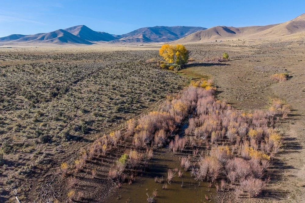
Serrell Smokey is chairman of the Washoe Tribe of Nevada and California, which recently purchased significant portions of ancestral land in the Sierra region. This land return marks one of the largest tribal reacquisitions in modern California history. The property—more than 10,000 acres of sagebrush scrublands and juniper and pine forests, once known as Loyalton Ranch—will now be stewarded by Indigenous hands.
He said the land is not just property, but a living cultural landscape tied to Washoe identity, history, and ecological responsibility.
“Technically, we as the heirs of my great-great-grandparents should be entitled to those allotment lands,” Smokey said. “So according to the current records…how come we’re not on those lands?”
The deal allows the tribe to control the property, about 20 miles north of Reno, Nev., and restore traditional cultural and conservation practices that were lost when the tribe was violently forced from the area.
He traces the history of his family’s lands with quiet frustration, pointing to tribal records and BIA documents that tell a story he knows all too well. The land north of Lake Tahoe once lay within Washoe ancestral homelands, stewarded by generations of Washoe families before being parceled off or sold over decades.
The lands lie within the traditional territory of the Wélmelti band—northern Washoe people who historically lived throughout the Sierra Valley before being violently displaced.
“The history is that Washoe people were specifically hunted in these areas,” Smokey said. “The bounty for Washoe scalps was paid out of Nevada City, right over the mountain.”
The preserve is vast and diverse, rising from sagebrush scrub and grasslands in the east to conifer forests, aspen groves and mountain meadows in the uplands to pinyon pines, rocky crags, springs and creeks in the west. Photo courtesy of Elizabeth Carmel / wasi-siwlandtrust.org
Even after the mid-19th century violence subsided, Washoe families remained scattered across the region. Many held small allotments on the very hillsides that now make up the newly reacquired property, but those lands were gradually lost through federal policies and bureaucratic maneuvering. Smokey pointed to tribal records showing that parcels once held or stewarded by Washoe families were leased or sold over the decades—sometimes to timber companies that no longer exist—and questioned how the lands became separated from the community.
“A lot of those allotments have been diminished or removed—I say stolen by the government,” he said. “Technically, we as the heirs of those families should still be entitled to those lands. But we were told we could no longer use the land for resources or ceremony. Since that time, the land has been calling us back, and we are answering that call.”
The reacquisition is significant not only for its history but also for its scale. At more than 10,000 acres, the purchase more than doubles the Washoe Tribe’s current land base, which is otherwise scattered across Nevada and California. Repossessing the land allows tribal members to practice traditional ways—gathering foods, harvesting medicines, and conducting ceremonies—without needing permits or outside approval.
“For a long time we’ve had to ask permission to practice our culture on our own homelands,” Smokey said. “Now our elders can teach our youth on land that’s ours.”
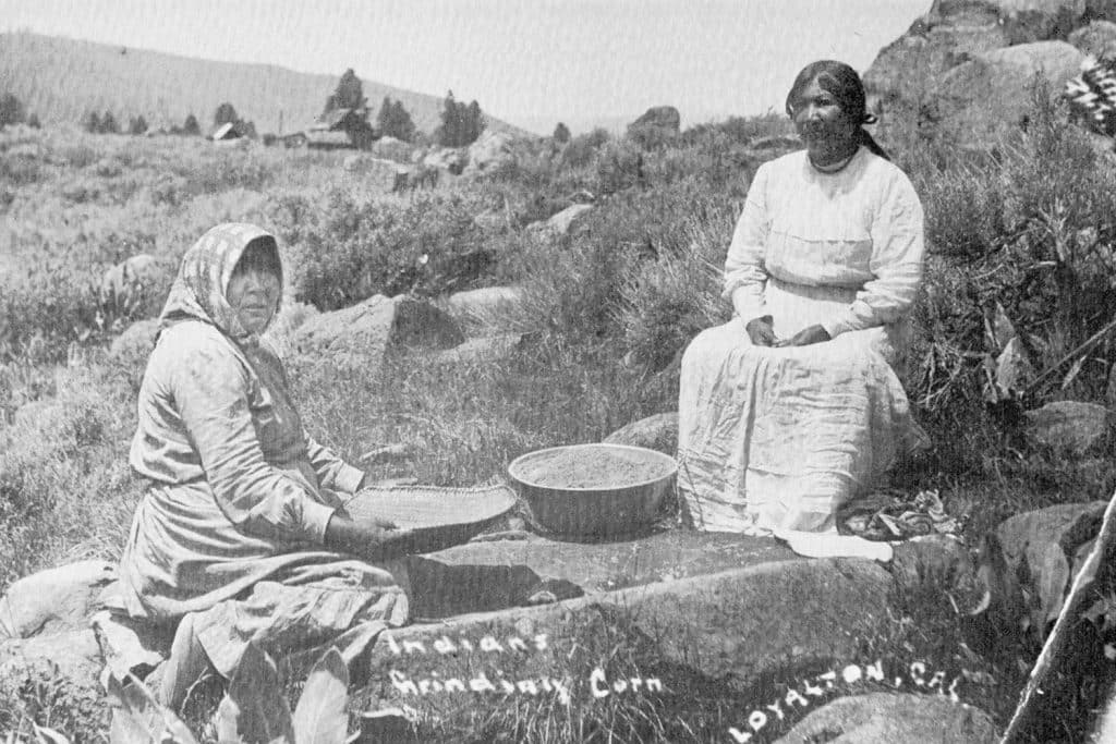
Washoe women grinding acorns in the WélmeltiɁ Preserve (1915), Milton Gottardi Museum
The purchase was made possible through a conservation partnership model, increasingly common for tribal land returns in California. Over several years, the Feather River Land Trust (FRLT) worked with the Washoe Tribe to incorporate their perspectives into land management and interpretive programming. In partnership with the Northern Sierra Partnership, FRLT helped identify priority ancestral lands for acquisition and guided the tribe in establishing their own nonprofit, the Wášiw‑šiw Land Trust, to hold and manage the property.
In 2025, the California Wildlife Conservation Board awarded a $5.5 million grant, covering most of the roughly $6 million acquisition cost, with additional funding from private donations and partner contributions.
“It’s both about the restorative justice of returning land to people who were violently removed from it, but also about restoring it to Indigenous stewardship — to the care of Indigenous people who have tended these lands for generations,” said FRLT executive director Corey Pargee.
Smokey acknowledges the paradox: Indigenous nations often must purchase lands that once belonged to them.
“People often ask, ‘You have to buy back your own land?’ Yes, we do. That’s the world we live in nowadays,” he said.
The reacquisition represents another milestone in California’s evolving “Land Back” landscape, where tens of thousands of acres have returned to tribal stewardship after generations of dispossession. Last June, the Yurok Tribe reclaimed approximately 47,000 acres near the lower Klamath River — the largest land return deal in state history. That same year, the Tule River Tribe similarly regained more than 17,000 acres of ancestral land in Tulare County, described by state officials as a historic land return in the Sierra Nevada foothills and Central Valley.
“When we brought youth out there, they looked around and asked, ‘This is ours?’” Smokey said. “I told them, ‘Not yet — but if you want it, we’ll fight for it.’”
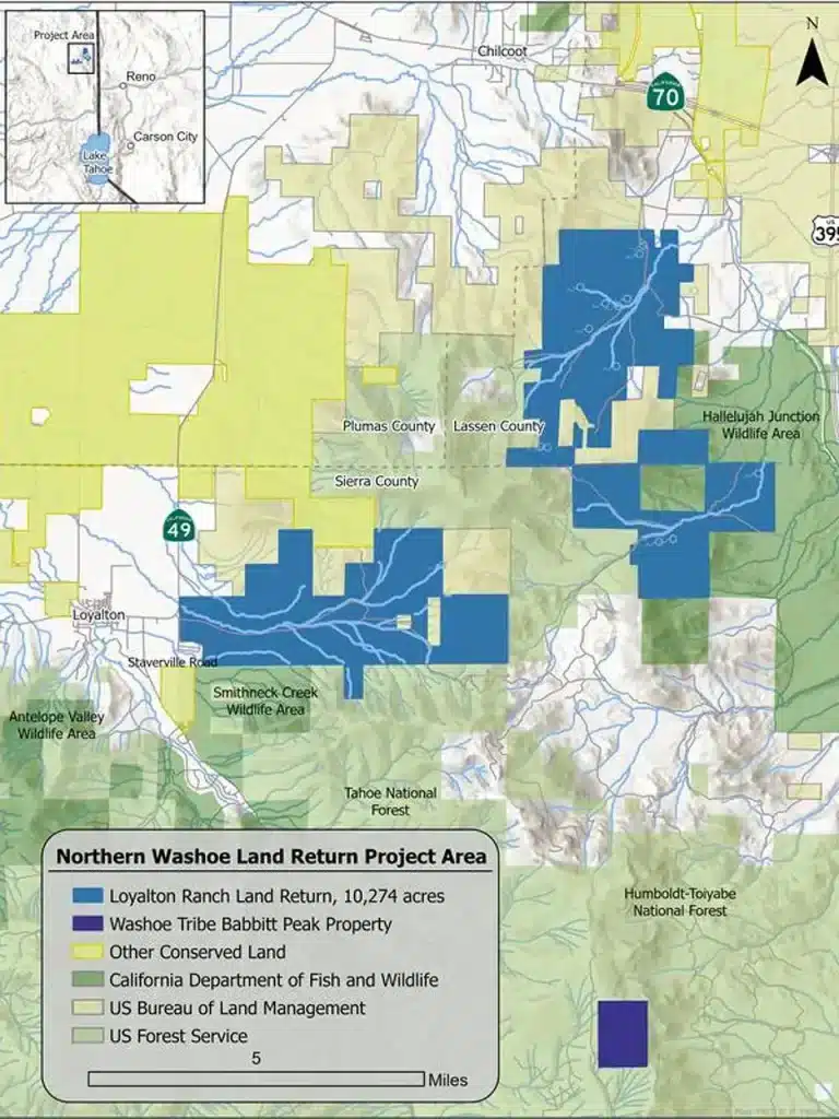
A map of the Loyalton Ranch property, in California, that is slated to be returned to the Washoe Tribe. Courtesy of the Wášiw-šiw Land Trust
The chairman calls the purchase “good medicine” for his people, “a small start to healing from generations of historical trauma, and the benefits will go on for many generations to come.”
Alongside reclaiming the ability to carry out traditional practices, the tribe plans to manage the land with conservation as its guiding principle, protecting habitats for pronghorn, mule deer, gray wolves, natural springs, and vital water sources. Tribal members themselves advocated for this conservation-first approach after visiting the property, ensuring that the land would be restored and cared for according to both ecological and cultural priorities.
“Everybody we took out there, from elders to young people, said the same thing,” Smokey said. “They didn’t want a bunch of houses or other development. They wanted to restore the land.”
The chairman also emphasized that the tribe has ruled out any commercial development on the land, including casinos or resorts.
“That’s the first thing people assume. But we are not a casino tribe. Our goal here is conservation and taking care of the land.”
This acquisition is not only a major achievement for the tribe but also reflects a landmark moment in the broader Land Back movement, calling for more Indigenous governance over historical territories and challenging longstanding settler frameworks of land use and conservation. For Smokey, it’s an opportunity for the Washoe Tribe to rebuild cultural connections to the land, reconnect youth to their historic homelands, and conserve the ecosystems that make up the area. He hopes the project will strengthen relationships with neighboring communities and demonstrate the role tribal stewardship can play in regional conservation.
“This land return is about opportunities for our people, but also for the community,” Smokey said. “We’re neighbors, we’re all living here, and we’re not going anywhere.”
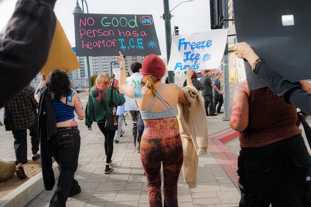
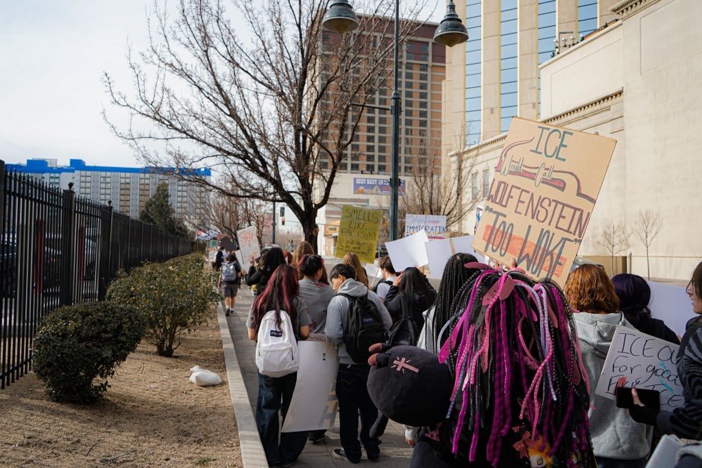
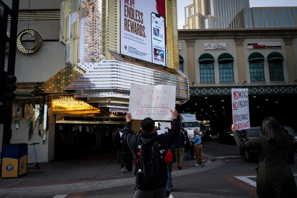
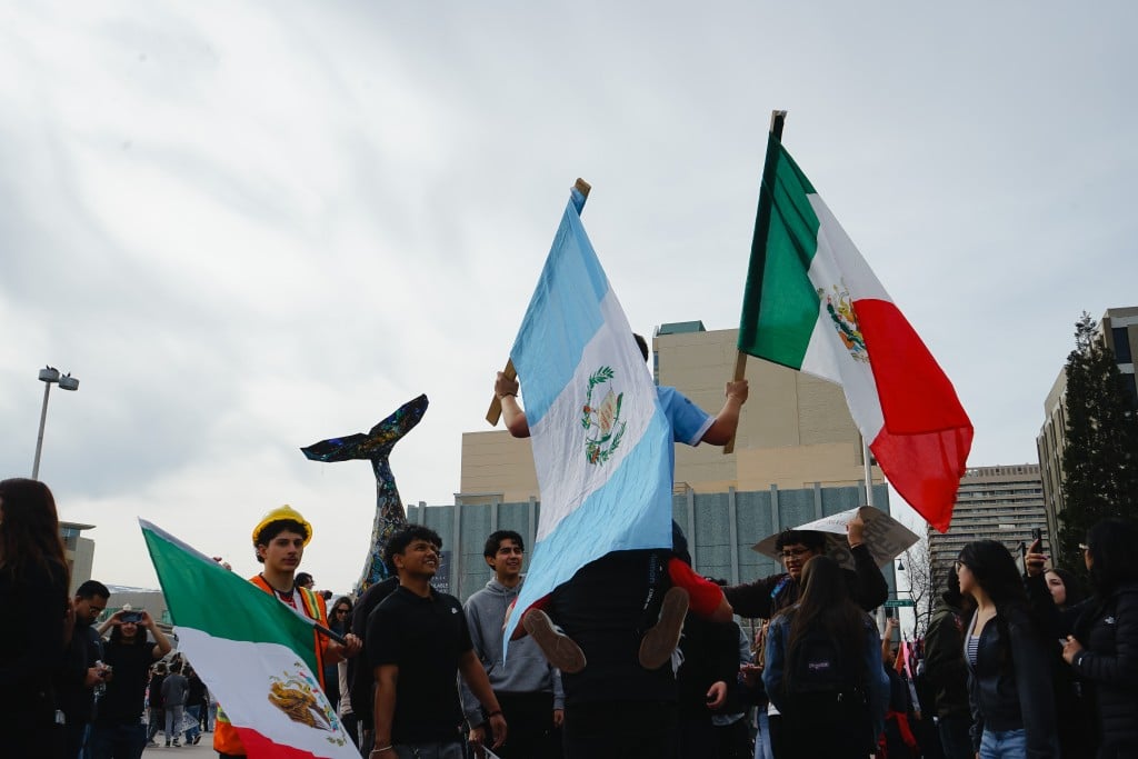
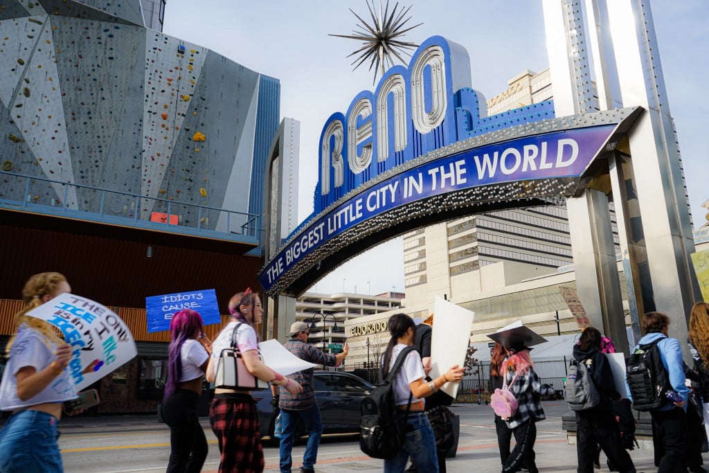
Photos: Students Walk Out to Protest ICE
As part of a grassroots, nationwide shutdown, students across the Washoe County School District left their classrooms on Friday, January 30. Led primarily by high school students, with participation from several middle schools, the student strike was organized in response to recent actions by U.S. Immigration and Customs Enforcement (ICE).
The walkout culminated around City Hall and across downtown Reno, where hundreds of students gathered, carrying Latin American flags and handmade signs as they rallied in protest of ICE.
Photos by Hannah Truby for the Sierra Nevada Ally
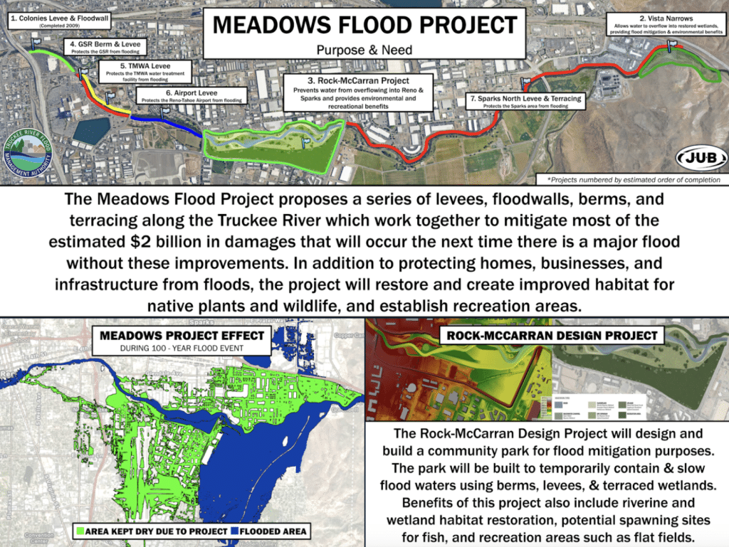
To Rewild the Truckee River: The Rock-McCarran Flood Project
Photo Richard Bednarski / Sierra Nevada Ally
Danielle Henderson laughs when friends call her a water nerd, but for her, the Truckee River is more than just a job–it’s a living system she’s spent 18 years learning to protect.
Henderson is the Natural Resources Manager for the Truckee River Flood Management Authority (TRFMA). For years, she has pondered a particular part of the river corridor, an area now being considered for a major flood mitigation project: The Rock-McCarran Flood Project.
“The Rock-McCarran project is like the showpiece of our flood project,” said Henderson.
According to the TRFMA, “the Rock-McCarran Design Project is part of a larger inter-agency plan called the Meadows Flood Project which will create a community park located along the Truckee River in the reach between the Rock blvd. and McCarran blvd. Bridges.” As it stands now, the area between Rock and McCarran Boulevards, the river is bound to the north by the river path and warehouses, but to the south lies mostly undeveloped land.
The Meadows Flood Project is TRFMA’s overall plan to alleviate flooding in the Truckee Meadows. (Courtesy: TRFMA)
In her role with TRFMA, Henderson is eager to see this project break ground, which will encompass nearly 170 acres of open space that will be revitalized, with river health and flood mitigation at the forefront.
And floods can be a serious issue for Northern Nevada.
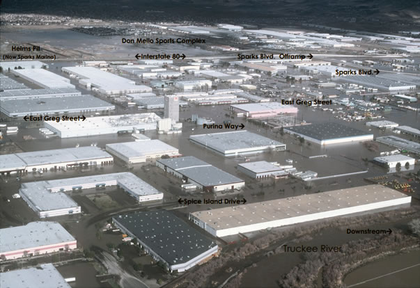
Since 1950, when there were two major floods, the Truckee River has caused major flooding in Reno seven times, roughly once every 11 years. The 2017 flood covered the Rock-McCarran Project area with one to two feet of water, affecting Hidden Valley, though it was not the region’s worst flood.
The 1997 “flood of record” occurred after a massive warm winter storm triggered a swift melting of mountain snowpack and severe runoff, submerging downtown Reno, the airport, and much of the southern valley.
View of Sparks industrial area on Jan. 3, 1997. Photo courtesy of Pat Glancy, USGS Carson City, NV
This event now serves as the baseline for what is considered a 100-year flood: a flood with a one percent chance of happening every year.
“The Rock-McCarran Project is designed to protect the community from flooding, and we are modeling our flood protection on the 1997 event,” said Henderson, adding that the project will restore and preserve open and green spaces.
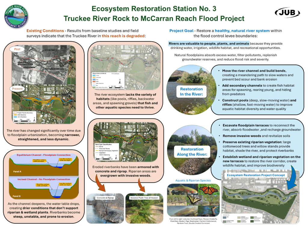
This section of the river has undergone numerous changes: heavily constrained and incised river banks, extensive hardscaping, and flood walls that channel high river flows with increased energy. Biodiversity is limited, with no natural pools or riffles that slow water flow.
Shane Dyer, an engineer from J-U-B Engineers, the company partnering with TRFMA on the project, said the river’s unnatural flow requires regular maintenance. He also noted surrounding farmland contributes to biodiversity loss, calling this section, “really just a man-made stretch.”
One early challenge of the project was the varied ownership of the land. Since 2011, TRFMA has worked with private owners, acquiring all but two lots needed for the project. Businesses have been relocated, and many existing buildings demolished. Remaining concrete pads and parking lots help mitigate potential erosion, weed infestation, and dust during construction.
Climate change is increasing the risk of major flooding as well. A 2023 study published by the American Geophysical Union found that, even with moderate emissions, regions worldwide could experience 100-year floods every 9-15 years by 2050. And a story published by Yale Climate Connections found that climate change is increasing the frequency of this major flood event.
Henderson said that if the river remains unchanged, damages from the next 100-year flood could reach $2 billion.
“We’re talking about creating meanders, backwater areas, pools, and riffles and spawning gravels to support fish, floodplain terraces,” Henderson said.”
Project Details
To address the risk, TRFMA anticipates breaking ground within a few years. J-U-B Engineering has identified natural techniques to restore more natural river activity, including:
Reestablishing back channels and floodplains
Eliminating deep incising
Creating riparian corridors and habitat for fish and wildlife
The project requires an extensive permitting process but aims to return a natural flow to this corridor.
“Fire and foremost, the community should care about the Rock-McCarran Project because it will avoid damages, keep people safe and healthy, and improve the region’s economic vitality,” Henderson said.
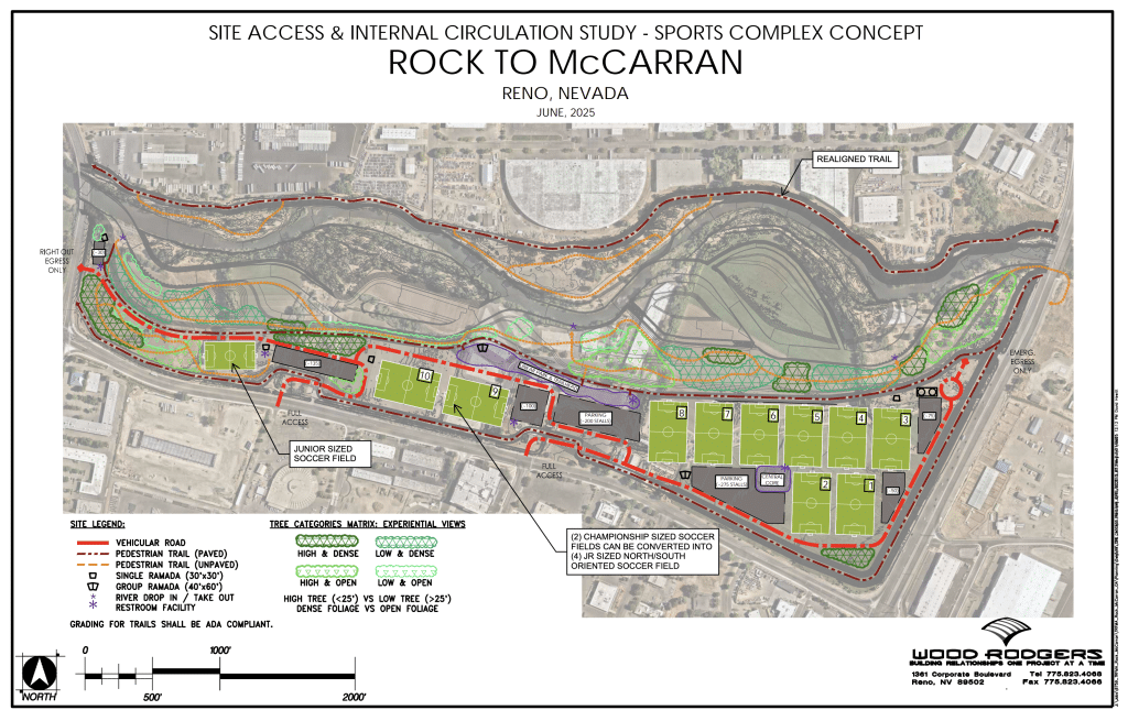
Henderson is particularly excited about plans for the 70 acres south of the river, where two concepts are being considered:
Trails, interpretive signage, pedestrian bridge, and bird blind
Passive recreation and ecological restoration
Concept Two: Traditional Sports Complex
Ten athletic fields
Extensive parking, lighting, and asphalt
Same river restoration as the nature park concept, but more infrastructure and maintenance
Addresses immediate demand for youth sports
There is community support and benefits to both approaches. According to the City of Reno’s 2023 Parks, Recreation, and Open Space Master Plan, there is a shortfall of 45 flat fields needed for athletic competition and recreation.
A conceptual plan for the nature park vision for the Rock-McCarran park along the Truckee River (Courtesy: TRFMA)
“There’s quite a few programs and youth sports that can’t provide the programming they would like due to limited fields,” said Ian Anderson, board member of the High Sierra Lacrosse League. “Families have to travel further, and kids miss out on opportunities to play.”
Anderson emphasized the benefits of the Rock-McCarran location for athletics: central, accessible by bus, and near hotels for tournaments.
The nature park concept, by contrast, emphasizes open space and flood resilience while restoring natural river flows.
“It’s kind of an extension of the restored river corridor,” said Henderson. “It would include different types of native vegetation, some meadow areas, mixed in with some more traditional park landscaping.”
TRFMA has held public meetings to gauge interest. In March, feedback strongly favored the nature park, while August sentiment shifted slightly toward favoring the sports complex. Written comments, however, still favor the nature park. Concerns for a sports park include noise, light pollution, runoff, and impacts on wildlife, such as the Brazilian Free-tailed bats living beneath the nearby McCarran Bridge.
The project also considers downstream communities and tribal stakeholders. Representatives from the Pyramid Lake Paiute Tribe serve on the technical advisory committee. Through negotiations, TRFMA has allocated $17 million to the tribe for restoration and bank stabilization. Coordination is ongoing with Lockwood, Wadsworth, and other downstream communities.
While still early in development, the TRFMA board will review public comments before deciding between the two concepts. Henderson emphasized that community feedback remains important even as plans progress from 15 to 30 percent design.
“People should care about the river,” Henderson said. “It’s our chance to protect the community, restore open space, and ensure a clean, healthy river for generations to come.”
Additional Reading: A Primer on TRFMA
TRFMA is a coalition representing the cities of Reno, Sparks, Washoe County, and other stakeholders. The agency’s ultimate goal is to reduce the negative impact of severe floods that can affect the overall health, economic, and social well-being of the community.
“We are funded entirely by local government funds,” said Daneille Henderson, Natural Resources Manager for the agency.
TRFMA gets some of its funding from a portion of sales taxes from Reno, Sparks, and Washoe County, which helps insulate the agency from broad-sweeping cuts from state and federal governments.
“We were not impacted by the recent funding cuts from the federal government,” said Henderson.
However, she mentioned the federal funding cuts have impacted several grant opportunities the agency had hoped to pursue.
According to the agency’s website, the “TRFMA is responsible for implementing the Truckee River Flood Management Project (Flood Project), which involves planning, designing, and constructing flood impact reduction projects and ecosystem restoration projects along the Truckee River. In addition, TRFMA works with the jurisdictions to maintain existing flood protection infrastructure along the river.”
Food is power
This article was produced in collaboration with High Country News. It may not be reproduced without express permission from FERN. If you are interested in republishing or reposting this article, please contact info@thefern.org.
Many communities have foods that define them: Los Angeles has tacos, Green River, Utah, has melons, while New Mexico’s Hatch Valley is famous for its green chiles. Historic power dynamics — from colonization to migration — have always influenced how and why people began growing, cooking and consuming these symbolic dishes and crops. Today, these foods and those who prepare, raise and sell them carry cultural power; people travel hundreds of miles to buy a juicy Crenshaw or sweet canary melon from a family-run stand in Green River. And yet the farmers themselves often struggle to stay afloat. They lose access to markets as large companies buy up smaller, locally run grocery stores.
Most grocery stores across the West trace back to a few major corporations. Whether you’re visiting King Soopers in Colorado, Smith’s in Utah or Fred Meyer in Oregon, you’ll find the same Kroger-brand products. The original names of the once-locally owned grocers might remain, but the shops are now just part of one of the nation’s largest grocery corporations.
A handful of companies control the production and distribution of most of our food, and the West plays a leading role in that system. The U.S. headquarters for the world’s largest meatpacker, JBS S.A., is in Greeley, Colorado, while Driscoll’s, the largest berry producer, is headquartered in Watsonville, California. These companies rarely confront the riskiest parts of agribusiness, raising the cows and growing the berries. Instead, they produce, brand and ship them.
This global food system has profound impacts on the West’s farmers, workers and consumers. It’s getting harder for family farms to turn a profit, and those who seek alternatives to the consolidated corporate market must navigate complicated policies and finances in order to sell directly to consumers. Berry-pickers and meatpacking workers — often immigrants — face exploitation and unsafe conditions, with workplace protections varying from state to state.
Meanwhile, food insecurity has increased across the West, and yet Republican-led states, including Utah and Idaho, opted out of a federal summer grocery program for kids last year, in part because of anti-welfare politics.
Beyond its connection to this international system, the West has deeply rooted myths and policies around water and land that create and sustain other layers of power. In the 1800s, settlers stole land from Native people and killed off bison as they drove tens of thousands of cattle westward. Ever since, the cowboy and his glorified cattle have held cultural power that politicians are rarely willing to tarnish.
As “The Big Four” meatpackers have consolidated most of the beef industry, the economic power of ranchers has dwindled. Only 2% of U.S. beef comes from cows that graze on public lands, and yet multigenerational ranching families and large landowners continue to influence and benefit from antiquated federal grazing policies.
Most land in the Eastern U.S. is privately owned, but the federal government owns nearly half of all land in the West. Ranchers graze cows on huge swaths of public lands, paying fees well below the actual cost of managing those lands. Over the past century, grazing policies have changed little even as cows destroyed native vegetation and degraded waterways. State and federal policies often put the health of livestock above that of the region’s arid soils or the lives of large carnivores like wolves and bears.
Ranchers and Big Beef also intersect and overlap with those who control water in the West. Agriculture consumes nearly 80% of the water diverted from the drought-stricken Colorado River Basin, primarily to grow alfalfa and other cattle-feed crops. An investigation by ProPublica and The Desert Sun found that most of the water consumed in California’s Imperial Valley goes to just 20 farming families, with one of them using more than the entire metropolitan area of Las Vegas. Only four of those families use the majority of their water rights to grow foods people consume, like broccoli or onions. The rest use their water to grow hay for livestock.
Many of these families have senior water rights, and that increasingly means power in the arid and rapidly growing West. Together with livestock associations, irrigation districts and their political allies, they have sought to influence food and water policy.
Yet in some parts of the West, other interests are gaining power. In the Northwest, years of advocacy from tribes and environmental groups led federal agencies to decommission dams on rivers like the Elwha and Klamath. The farmers might worry about their ability to continue irrigating, but tribes are reclaiming their traditional foodways as salmon return.
And the Northwest’s rivers aren’t the only places where tribes are reasserting their culture and food sovereignty: Indigenous-run restaurants, farms and cooking classes are springing up across the West.
Farmers markets, mutual aid efforts and community gardens are creating new forms of cultural, social and economic power, often led by and benefiting those who are excluded and marginalized, including queer, immigrant and Black farmers. Their efforts encourage people to take back intrinsic food traditions while they act in resistance to the global, capitalist food system.
Still, the corporate structures of our food system are so deeply entrenched that they can be hard to fully comprehend or even notice. In this region, food is power, and that power is not equally shared. Before that can change, however, we need to understand the complexities of this system, tracing its roots to the growth of retail giants and the consolidation of Western agricultural production.
The grocery giants
A handful of powerful corporations dominate the U.S. grocery market. Over the last few decades, these firms have consolidated their control, leaving a shrinking share of the market for local, independent grocers. Grocery giants and their supporters claim that economies of scale enable them to offer lower prices to consumers. But critics say that these conglomerates’ size gives them too much power, not only over their consumers, but also over suppliers and workers.
Corporate consolidation in U.S. grocery
Breaking down the big grocery firms
Note: Walmart, Kroger, Costco and Albertsons were the four largest firms in grocery by market share in 2023, according to industry reports. To estimate the footprint of these grocery giants, HCN used USDA data on SNAP-authorized grocery stores. While not every retail location accepts SNAP, we cross-referenced the data with corporate reports and found our totals closely matched the store counts listed by the largest firms.
Walmart & Costco: The West’s superstore empires
SNAP-authorized Walmart & Costco stores in the West
Note: Includes SNAP-authorized Sam’s Club
stores, which are owned by Walmart. Store totals
are for the 12 Western states.
The illusion of competition
Confronted by Walmart’s growing power, traditional grocers like Albertsons and Kroger responded with a spate of mergers and acquisitions starting in the early 1990s. Albertsons now owns over 1,300 stores in the West, though few of the shoppers patronizing Safeway and Haggen may realize that those stores are owned by the same firm. In December of 2024, the Federal Trade Commission blocked a proposed merger between Albertsons and Kroger after a number of Western states sued, arguing that it would further limit competition and raise prices for consumers.
Farmers markets — a bright spot in the grocery landscape
The rise in the popularity of farmers markets since the mid-1990s has been a positive counterpoint to the relentless march of corporate consolidation. Nationally, the number of farmers markets more than quadrupled from 1994 to 2019.
Get big or get out: Consolidation in agricultural production
The small family farm holds a special place in the American imagination. Today, however, a modest and diminishing portion of our nation’s food is grown on smallholder farms. Production is shifting to larger-scale factory farms in every Western state and across nearly every commodity.
Production shifts to larger farms
Marked growth for select goods
Giants of agricultural production
Net loss of 600,000 U.S. farms 1982-2022
The trend towards consolidation in the food system has made it increasingly difficult for smaller farmers to compete and stay in business.
Concentration in meatpacking
The meatpacking industry is concentrated to an extraordinary degree, with an estimated 81% of U.S. cattle and 65% of hogs processed by “The Big Four” meatpacking corporations as of 2021. Critics say this market stranglehold gives The Big Four too much control over both ranchers and consumers.
The above hourglass power dynamic is not unique to meatpacking; it’s also conspicuous in the seeds, agricultural chemicals and food retail markets. The concentration of power in these industries allows a handful of companies to dictate prices and production methods, trapping Western consumers in a food system that prioritizes corporate profits over sustainability, diversity and equity.
Help us keep digging!
FERN is a nonprofit and relies on the generosity of our readers. Please consider making a donation to support our work.
Don’t miss FERN’s latest revelations, developments, and initiatives. Sign up for our newsletter and we guarantee you’ll never miss one of our stories.
Students Stung by Truckee Turning Down Bee City Proposal
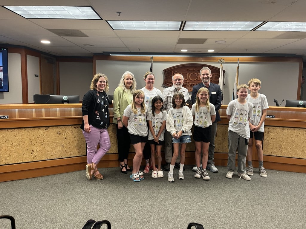
Ms. Colleen’s third grade class after giving their presentation at the town council meeting. Photo Kayla Anderson / Sierra Nevada Ally
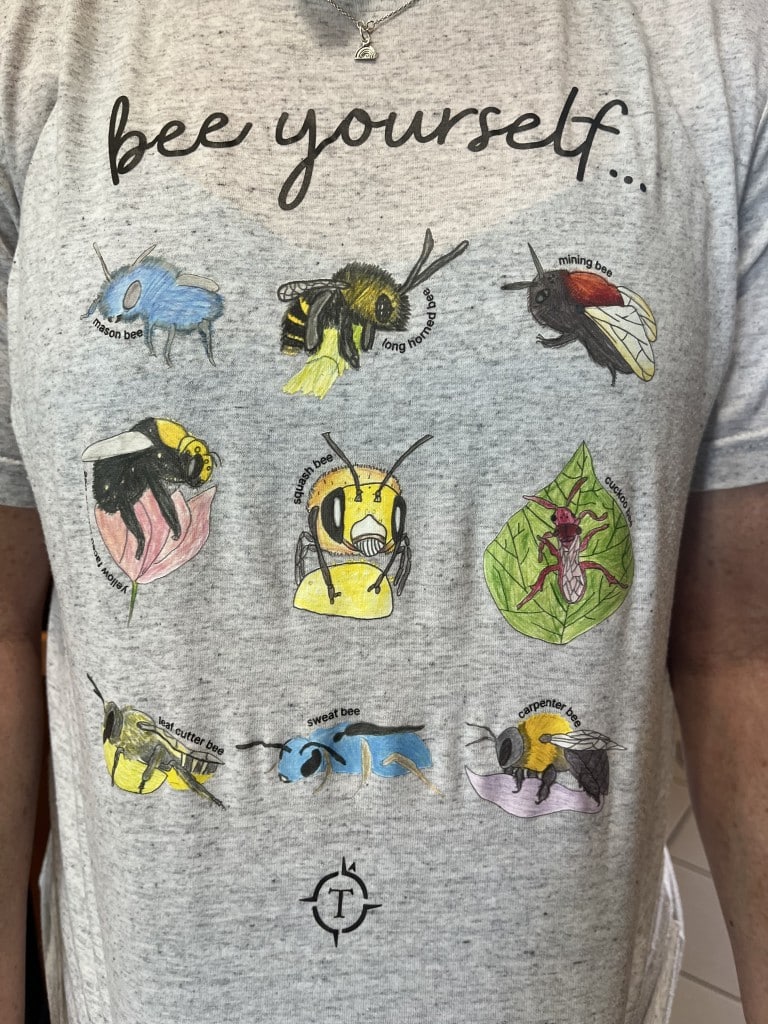
On a June evening during summer break for local schools, six third graders from the Tahoe Expedition Academy (TEA) donning “Bee Yourself” t-shirts and holding index cards took to the podium.
Their audience? The Truckee Town Council. Their goal? Get Truckee to agree to become an official Bee City.
“We would like to start by asking all of you on Town Council a question: What different types of bees can you name?” one girl asked.
One councilmember called out, “Yellowjacket.”
“That’s actually a type of wasp, and that is not a bee,” the girl corrected her. “But don’t worry, most adults can’t name very many native bees. Most often, when people think of the word bee, they think of honeybees or maybe bumblebees (and sometimes even wasps). But guess what, honeybees aren’t even native.”
The students explained that honeybee numbers are very stable while native bee numbers are decreasing. There are about 3,600 native bee species in the U.S. and 1,600 bees native to California. According to Bee City USA, up to 40% of invertebrate pollinator species globally are on the verge of extinction due to habitat loss, pesticides, diseases and climate change.
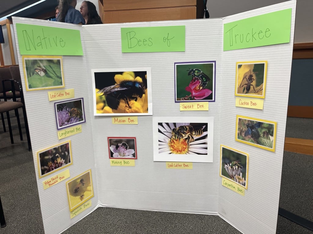
The students’ board displayed in front of the town council podium showing the native bees of Truckee. Photo Kayla Anderson / Sierra Nevada Ally
“That is not good statistics!” one student said.
Students described the bees native to our area, such as Mason Bees, Bumblebees, Carpenter Bees, Mining Bees, Cuckoo Bees, Sweat Bees, Long-Horned Bees, and Leaf Cutter Bees.
“These unfamiliar bees are the ones that we should be worried about. Without these native bees, our ecosystem would become imbalanced, and it would also cause a huge disruption to our food chain and many of the food crops that we eat,” a student said.
Another asked, “Do you have any ideas as to why our native bees are declining right now?”
“Loss of habitat,” Town Councilmember Dave Polivy answered.
The student confirmed that was indeed the case.
“The two main reasons are native bees are losing their habitat because people are building more houses or disturbing overwintering nests, and bees are getting sick and dying from people using chemical pesticides to kill weeds and other bugs,” the student said.
After a few minutes of persuasion, the students then issued a call to action to the town of Truckee: make the necessary requirements to become a Bee City USA affiliate.
“As a Bee City, Truckee would make a commitment to save native pollinators,” they said.
Bee City USA is an initiative of the Xerces Society, a conservation advocacy organization. To become an affiliate “Bee City,” the town of Truckee would need to establish a standing Bee City USA committee, create and enhance pollinator habitat on public and private lands, reduce the use of pesticides, incorporate more pollinator-friendly policies into city plans, and host pollinator awareness events, in addition to some administrative requirements.
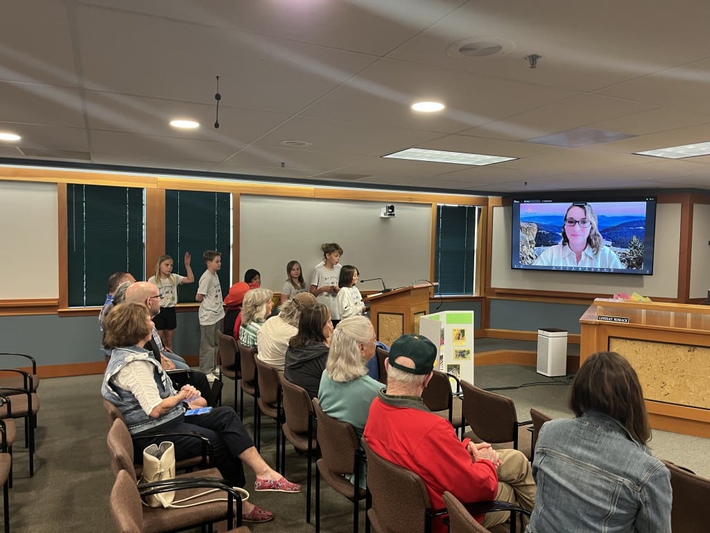
Ms. Colleen’s third grade class gives their presentation at the Truckee Town Council meeting. Photo Kayla Anderson / Sierra Nevada Ally
To help, the students offered to have their school help support the required committee, put together a native pollinator friendly plant list that could be distributed to individuals and at nurseries, host events at the school, and even help with funding.
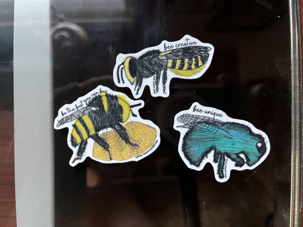
“Our school is committed to helping pay the application fee from funds we raised selling our bee t-shirts and sweatshirts,” one student said.
The students said to become a Bee City, the town would create a pest management plan to reduce the use of chemical pesticides and expand the use of non-chemical pest management.
“Did you know that you can make sprays to prevent animals, insects and fungi from destroying your garden? You can make a spicy spray, a milk spray, and even a soap spray! Our school could also help put a list together for the public with suggestions to reduce pesticide use,” a student said.
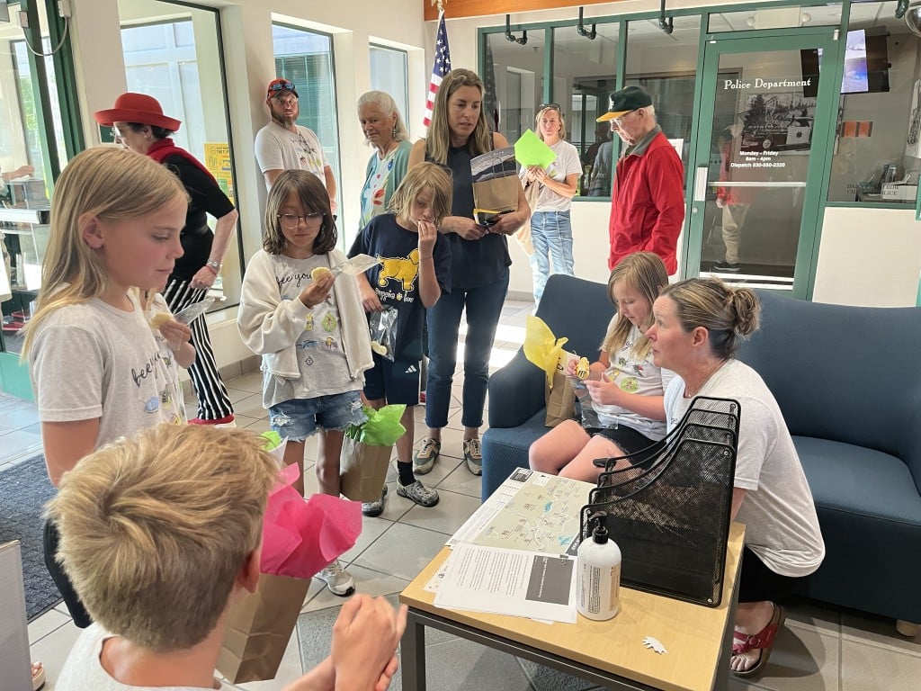
Following the impassioned presentation, the town council thanked them and gave the kids a swag bag filled with a coloring book, a pair of socks, Chapstick, a pen, a sticker, and a bee-shaped cookie.
But, they ultimately said no to the proposal.
“That was a great job on the annual bee presentation. It is not in our work plan this year, but we will look into it for future years,” Polivy said.
All the other councilmembers remarked it was a great presentation, congratulating the students on their initiative, research, and becoming knowledgeable and informed on the topic. One councilmember suggested partnering with the Truckee-Tahoe Unified School District regarding its pest management plan it has in place and another councilmember offered to reach out to SWEP (Sierra Watershed Education Partnership) as it promotes environmental stewardship with students in the Truckee/Tahoe region.
“I looked into the Bee City and listened to the presentation. I realized that is a big project to become a Bee City and the Town Council [has] put the project on a waitlist, if you will. But I don’t think you should wait for the town on this and there are nonprofits we could work with,” Mayor Jan Zabriske said to the students.
Despite the recommendations and suggestions, the council’s response was disappointing to teacher Colleen Carr.
“They own this,” Carr said about the kids’ obsession with the bees. “Every class that’s been involved with this project has been so passionate about it.”
Ms. Colleen talks with the students following their presentation. Photo Kayla Anderson / Sierra Nevada Ally
Carr shares that passion. Wearing a blue t-shirt with a Mason bee on it–which she said people confuse for a fly–she also showed off the Mason bee tattoo she has above her ankle. That love is reflected in the passion of her third-grade class, which goes in the field every week to meet with environmental/biology experts.
“I’m now known as The Bee Lady,” Carr said. “I was that person who couldn’t name anything besides the bumblebee and the honeybee and now I absolutely love them.”
Carr has been working on this Bee City USA proposal for three years. In 2023, her class sent a series of persuasive letters to the town council, and her 2024 class spoke with Dave Polivy in the council chambers.
“This was a huge step in coming here on your summer vacation, and this is the first time in front of the entire city council,” Carr said.
When asked what the primary roadblock was to Truckee becoming a Bee City, Carr said it was the forming of a committee.
“There is a Help Save the Bees nonprofit in Reno, and maybe that helped them get their designation [of Reno being the Biggest Little Bee City],” she said.
Truckee Mayor Jan Zabriskie confirmed that there is a difference between endorsing a program and implementing it, while balancing the other issues that have taken precedence in Truckee’s town master plan, such as solving the housing crisis.
A ‘Bee Yourself’ T-shirt designed by TEA students. Photo Kayla Anderson / Sierra Nevada Ally
He believes that developing a plan is a project best spearheaded by a nonprofit.
“We do have in our [2040] General Plan protections for sensitive habitats, wildlife corridors, and wetlands, and the bees would be part of that. The resources are here with the Native Plant Society, SWEP, and others, just not within the town government,” Zabriskie said.
He also affirmed that becoming a Bee City is competing with other priorities such as building infrastructure and fixing housing needs–while managing town staff that is feeling pinched by all these projects.
“The town just went through an organizational assessment and one criticism is the town council is asking too much of staff,” Zabriskie said.
Zabriskie adds that the town council is happy to take more suggestions on the need for establishing a Bee City, how to approach it, and how to improve its current bee populations.
“There are two things going on here: 1) form a Bee City or not; and 2) how can we improve the bee habitat. Following the second one will help accomplish the first one.”
Ultimately for now, town leaders said they are interested in the idea, and are encouraging students in Carr’s class to connect with local nonprofits to help alleviate some of the burden on town staff.
“We can look at becoming a Bee City, but someone else needs to take that on and then we can endorse it,” Zabriskie said. “There’s much appreciation from the town council for TEA looking into this, but we need someone to spearhead, organize this, and bring in other groups. That’s the rub.”
Unfortunately for the third-graders in Colleen Carr’s class, the competing town priorities mean it’s unlikely that Truckee will BEEcome a Bee City anytime soon.
Bee stickers handed out by the TEA students. Photo Kayla Anderson / Sierra Nevada Ally
As part of the larger Pride Month in June, the town of Truckee, Calif. held its second annual Pride Week last week. The celebration is a time when cities and towns all around the world host events celebrating the LGBTQ+ community in an effort to make their communities more diverse and inclusive.
“Rural environments across America are often harder places for queer people to live. That is why we believe bringing people together in all shapes and forms is so valuable and can have a meaningful impact,” said David Mack, Founder and Lead Organizer of Truckee Pride.
Photo Brooke Hess-Homeier / Sierra Nevada Ally
Photo Brooke Hess-Homeier / Sierra Nevada Ally
Truckee Pride offered a unique spin on the typical Pride celebration by bringing in a strong element of the outdoors. The week featured 37 events, many of which involved the outdoor adventure sports that Truckee is known for. There was a group mountain bike ride, a bouldering night, a queer film screening, yoga classes, a queer book fair, a dance party, a puppy parade, a lake paddle, and many more fun events that everyone was welcome to attend.
Photo Brooke Hess-Homeier / Sierra Nevada Ally
Photo Brooke Hess-Homeier / Sierra Nevada Ally
Photo Brooke Hess-Homeier / Sierra Nevada Ally
Photo Brooke Hess-Homeier / Sierra Nevada Ally
More than 2,000 people attended Truckee Pride events – many of which were hosted and sponsored by local businesses. Truckee Pride is a volunteer-run 501(c)3 non-profit, which plans to host this week each year in June.
Photo Brooke Hess-Homeier / Sierra Nevada Ally
Photo Brooke Hess-Homeier / Sierra Nevada Ally
Photo Brooke Hess-Homeier / Sierra Nevada Ally
Photo Brooke Hess-Homeier / Sierra Nevada Ally
Photo Brooke Hess-Homeier / Sierra Nevada Ally
Photo Brooke Hess-Homeier / Sierra Nevada Ally
Senate Republicans want to sell 3 million acres of public land
Over 3 million acres of public land could be sold in the next five years, after Senate Republicans on the Energy and Natural Resources Committee reintroduced land sales into the party’s major spending bill.
Released on Wednesday night, the megabill text includes a proposal for extensive transfers of U.S. Forest Service and Bureau of Land Management lands, supposedly for housing but with leeway for other uses. The new bill text escalates a recent GOP push to sell federal land. In May, the House Natural Resources Committee passed a version of the spending bill that called for 500,000 acres of public land sales in Nevada and Utah.
The Senate bill instructs the Secretaries of Interior and Agriculture to dispose of .5%-.75% of all BLM and Forest Service lands, respectively. While the percentage appears small, each agency manages huge swaths of land, mostly in the Western U.S. The BLM oversees 245 million acres, equating to 1.23 million to 1.84 million acres for sale under this proposal. The Forest Service manages 193 million acres, which would mean 970,000 to 1.45 million acres would be sold off if the bill passes.
In all, the total amount of public lands for sale could be as high as 3.29 million acres. The bill text would allow sales in all western states, except Montana.
“This Senate version is just open season on public lands.”
“It’s a travesty that Senate Republicans are putting more than 3 million acres of our beloved public lands on the chopping block to sell at fire-sale prices to build mega mansions for the ultrarich,” Patrick Donnelly, Great Basin director at the Center for Biological Diversity, said in an emailed statement. He noted that the proposal’s broad language differed from the House version that focused on lands already identified for disposal in resource management plans.
“This Senate version is just open season on public lands,” Donnelly added.
If passed into law, the new proposal would create a process for states, local governments and tribes to have a “right of first refusal” on public land sales — suggesting that if these entities did not want to purchase these parcels, private buyers would be considered. The proposal also prohibits the sale of national parks (which are not managed by the BLM or the Forest Service), national monuments, wilderness areas and national recreation areas, as well as land with mining claims, grazing permits, mineral leases and right of ways.
An aerial view from the Book Cliffs, Bureau of Land Management land, across the Grand Valley towards Grand Junction, Colorado. Credit: Luna Anna Archey/High Country News
Local governments near parcels that sold would get 5% of the proceeds “for essential infrastructure directly supporting housing development or other associated community needs,” while the public land agency would get 5% for deferred maintenance.
Senate Committee on Energy & Natural Resources — Members in the West:
Republican: Chairman Mike Lee, Utah John Barrasso, Wyoming James E. Risch, Idaho Steve Daines, Montana Lisa Murkowski, Alaska
Democrat: Martin Heinrich, New Mexico Ron Wyden, Oregon Maria Cantwell, Washington Catherine Cortez Masto, Nevada John Hickenlooper, Colorado Alex Padilla, California Ruben Gallego, Arizona
Attempts to sell public land are not new. But during President Trump’s second term, opponents of federal land management have couched transfers as a solution to the housing crisis. The Senate committee’s one-page summary of the plan blames the federal government for “depriving our communities of needed land for housing and inhibiting growth.”
A recent analysis by Headwaters Economics found that public land transfers offer little promise as a housing solution.
“Our findings show that opportunities are limited to a few states, and are complicated by wildfire and drought risks, as well as other development challenges,” the researchers wrote. They found that less than 2% of Forest Service and Department of Interior land is close enough to population centers to make sense for housing development.
The only viable chunks of Forest Service land — defined as 5,000 acres or more — near towns are in Arizona, Utah and Oregon. Department of Interior parcels that could work for housing development are primarily in Nevada, Arizona, California, New Mexico and Utah, according to the analysis. Economists also found that more than half of federal lands within a quarter-mile of towns needing more housing and a population of at least 100 people had high wildfire risk.
Research also shows that creating more housing in scenic resort towns and gateway communities doesn’t usually result in more affordable housing. “If you build more housing and your community is a very popular place to visit, then often that housing gets consumed by short-term rentals” or second homes, Danya Rumore, founder and co-director of the Gateway and Natural Amenity Region Initiative at Utah State University, toldHigh Country News last year.
The Hughes Fire burns Forest Service land near Castaic, California, this January. Credit: Andrew Avitt/U.S. Forest Service
A broad bipartisan coalition opposes selling public land, especially among Western voters. Some members of the committee, like Steve Daines (R-Mont.), have specifically said they would not support disposing of federal land. “Sen. Daines opposes public land sales,” spokesperson Matt Lloyd told the Montana Free Press on June 4. Idaho Senator James Risch (R) has also publicly opposed such sales. Montana Republican Representative Ryan Zinke — also Trump’s former DOI secretary — was instrumental in removing land sales from the House spending bill.
“Our findings show that opportunities are limited to a few states, and are complicated by wildfire and drought risks, as well as other development challenges.”
Chairman Mike Lee (R-Utah) has long championed attempts to sell federal land or transfer it to the states. Other Energy and Natural Resources Committee members represent Wyoming, Idaho, New Mexico, Utah, Washington, Oregon, Nevada, Colorado, California and Arizona and Alaska — all states with thousands of acres of public land.
If the committee passes this version of their megabill, a vote on public land sales would go to the entire Senate, and then, the House of Representatives. If this becomes law, it could “establish a model for members of Congress to liquidate America’s lands at any time to pay for their pet projects, with little benefit to local communities,” said Michael Carroll, director of the BLM campaign at The Wilderness Society, in a statement.